MyTopo
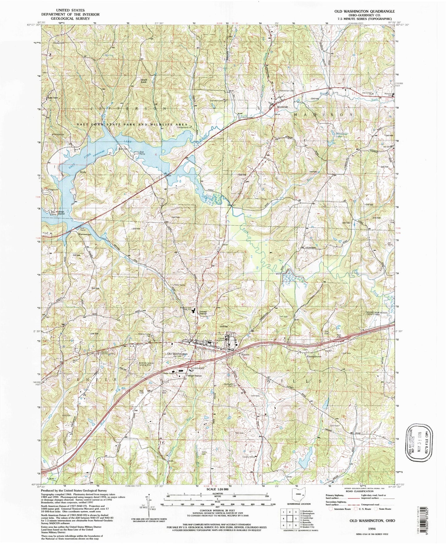
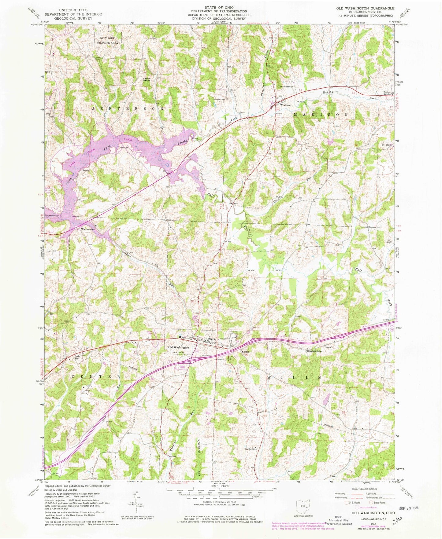
Classic USGS Old Washington Ohio 7.5'x7.5' Topo Map
Couldn't load pickup availability
Historical USGS topographic quad map of Old Washington in the state of Ohio. Typical map scale is 1:24,000, but may vary for certain years, if available. Print size: 24" x 27"
This quadrangle is in the following counties: Guernsey.
The map contains contour lines, roads, rivers, towns, and lakes. Printed on high-quality waterproof paper with UV fade-resistant inks, and shipped rolled.
Contains the following named places: Allen Cemetery, Beeham Run, Brushy Fork, Christian Creek, Coon Run, Glenview Cemetery, Madison High School, Salt Fork Wildlife Area, Winterset Cemetery, Devils Knob, Easton, Elizabethtown, Warrentown, Winterset, Madison Elementary School, Brushy Fork Church (historical), Grand Ridge School (historical), Shipley School (historical), Buckeye Trail High School, Old Washington Elementary School, Allen Chapel (historical), Crossroads School (historical), Fourmile School (historical), Deep Cut School (historical), Institute School (historical), Brady, Old Washington, Old Washington Historic District, Guernsey County, Salt Fork Reservoir, Winterset Lake Dam, Winterset Lake, Brothers Aviation (historical), Township of Center, Township of Jefferson, Township of Madison, Township of Wills, Elizabethtown Cemetery, McQuade Cemetery, Old Washington Cemetery, Brady Post Office (historical), Winterset Post Office (historical), Old Washington Post Office (historical), Village of Old Washington, Old Washington Volunteer Fire Department, Oak Hill Mobile Home Village, Butternut Dairy, Hendershot Farm, La Rue Airport, Old Washington Post Office, Allen Cemetery, Beeham Run, Brushy Fork, Christian Creek, Coon Run, Glenview Cemetery, Madison High School, Salt Fork Wildlife Area, Winterset Cemetery, Devils Knob, Easton, Elizabethtown, Warrentown, Winterset, Madison Elementary School, Brushy Fork Church (historical), Grand Ridge School (historical), Shipley School (historical), Buckeye Trail High School, Old Washington Elementary School, Allen Chapel (historical), Crossroads School (historical), Fourmile School (historical), Deep Cut School (historical), Institute School (historical), Brady, Old Washington, Old Washington Historic District, Guernsey County, Salt Fork Reservoir, Winterset Lake Dam, Winterset Lake, Brothers Aviation (historical), Township of Center, Township of Jefferson, Township of Madison, Township of Wills, Elizabethtown Cemetery, McQuade Cemetery, Old Washington Cemetery, Brady Post Office (historical), Winterset Post Office (historical), Old Washington Post Office (historical), Village of Old Washington, Old Washington Volunteer Fire Department, Oak Hill Mobile Home Village, Butternut Dairy, Hendershot Farm, La Rue Airport, Old Washington Post Office