MyTopo
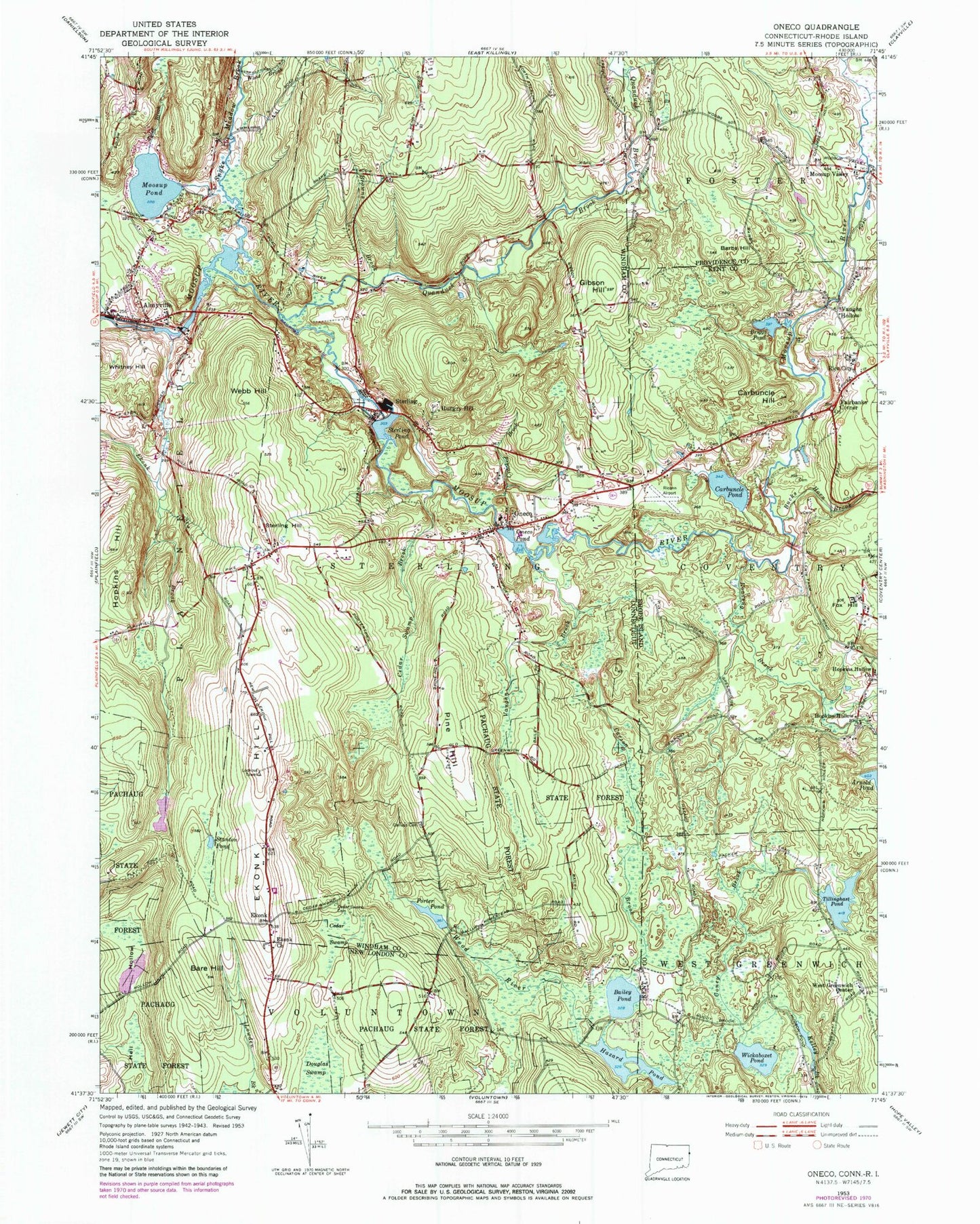
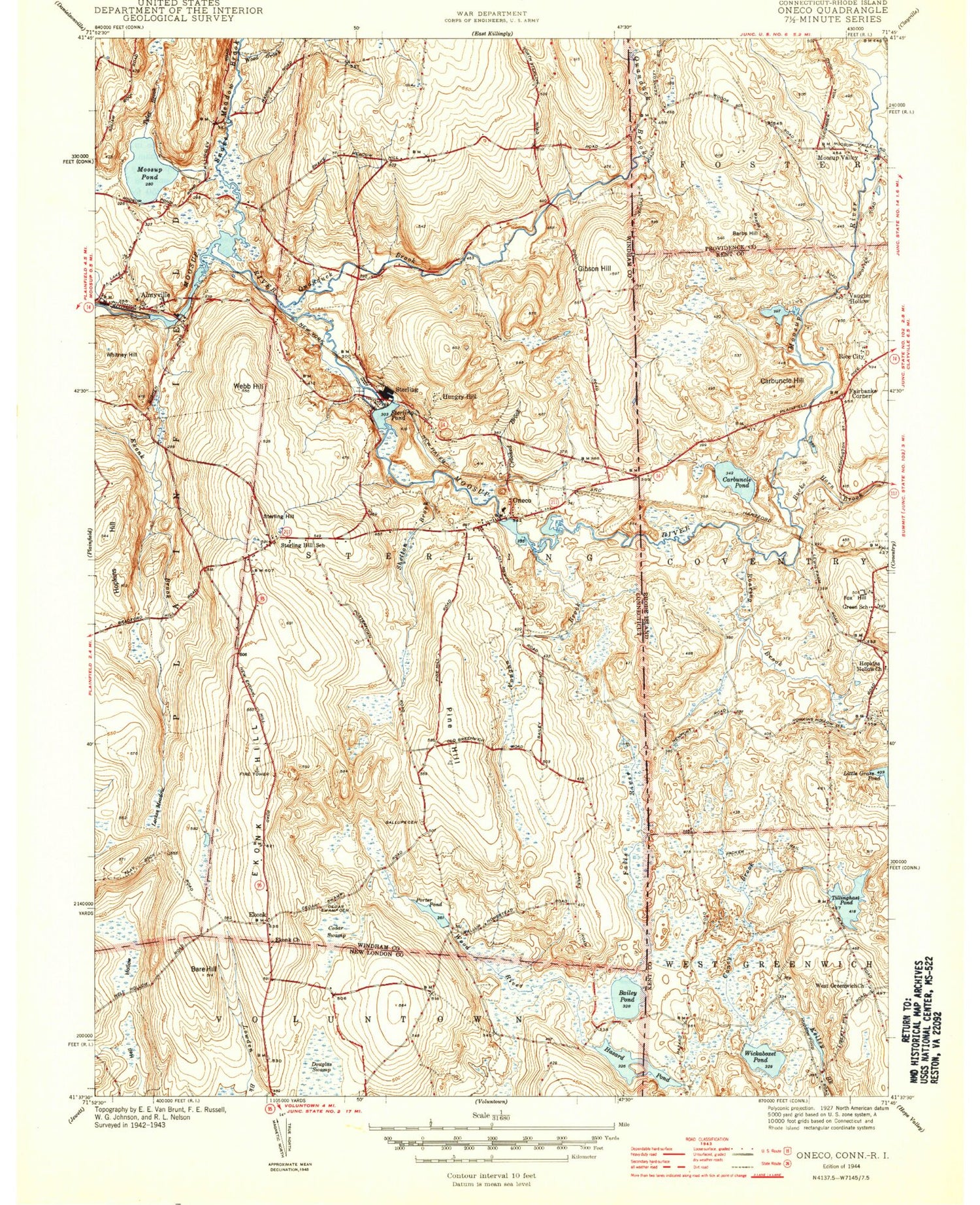
Classic USGS Oneco Connecticut 7.5'x7.5' Topo Map
Couldn't load pickup availability
Historical USGS topographic quad map of Oneco in the states of Connecticut, Rhode Island. Typical map scale is 1:24,000, but may vary for certain years, if available. Print size: 24" x 27"
This quadrangle is in the following counties: Kent, New London, Providence, Windham.
The map contains contour lines, roads, rivers, towns, and lakes. Printed on high-quality waterproof paper with UV fade-resistant inks, and shipped rolled.
Contains the following named places: Almyville, Bailey Pond, Bare Hill, Browns Brook, Carson Brook, Cedar Swamp, Cedar Swamp Brook, Cedar Swamp Cemetery, Crooked Brook, Douglas Swamp, Ekonk Church, Ekonk Hill, Gallups Cemetery, Gibson Hill, Hazard Pond, Hopkins Hill, Hungry Hill, Moosup Pond, Oneco, Oneco Pond, Pine Hill, Porter Pond, Quanduck Brook, Snake Meadow Brook, Stanton Pond, Sterling, Sterling Hill, Sterling Pond, Tyler Brook, Vaughn Brook, Webb Hill, Withey Hill, Wood Brook, Ekonk, Town of Sterling, Brunswick Dam, Moosup Pond Dam, Sterling Pond Dam, Oneco Pond Dam, Hell Hollow Pond Dam, Hell Hollow Pond, Dixon Brook, Lockes Meadow (historical), Oneco Fire Department Station 68, Oneco Post Office, Oneco United Methodist Church, River Bend Campground, Riverside Cemetery, Roger Lake, Silver Ridge Campground, Sterling Volunteer Fire Department Station 67, Sterling Fire Tower, Sterling Hill Baptist Church, Sterling Hill Historic District, Sterling Hill School (historical), Sterling Memorial School, Sterling Park Campground, Sterling Post Office, Sterling Pound, Sterling Public Library, Sterling Police Department, Young Lot Cemetery, Wickaboxet Pond, Coney Brook, Tillinghast Pond, West Greenwich Center, Fox Hill, Roaring Brook, Bucks Horn Brook, Carbuncle Pond, Carbuncle Hill, Rice City, Briggs Pond, Barbs Hill, Moosup Valley, West Meadow Brook, Riconn Airport, Arnold Pond Dam, Gorham Farm Pond, Gorham Farm Pond Dam, Hopkins Hollow, Fairbanks Corner, Vaughn Hollow, Carbuncle Pond Management Area, Hopkins Hollow Church, Nicholas Farm Management Area, Rice City Baptist Church, Rice City Historical District, West Greenwich Baptist Church, Plain Meeting House Cemetery, Fisher Country Club, Mooseup Valley Historic District, Tyler Free Library, Greene Public Library, Hianloland Fire Company Station 2, Dorrance - Jencks Lot, Moosup Valley Cemetery, Reverend Isaac Blanchard Lot, Thomas Brayton Lot, Daniel Ladd Lot Cemetery, Colonel John McGregor Lot Cemetery, Wood Cemetery, Gibbs - Westcott Lot Cemetery, Fairbank Cemetery, Josiah Potter Cemetery, Charles Jordan Lot Cemetery, Bates - Ryder Lot Cemetery, Thomas Morris Lot Cemetery, Allen - Tanner Lot Cemetery, Fiske - Andrews Lot Cemetery, Allen James Lot Cemetery, Jedidiah Shaw Lot Cemetery, Thomas Tillinghast Lot Cemetery, Stone - Wilcox Lot Cemetery, Stephen Burlingame Lot Cemetery, John Lewis Cemetery, Waite - Tillinghast Lot Cemetery