MyTopo
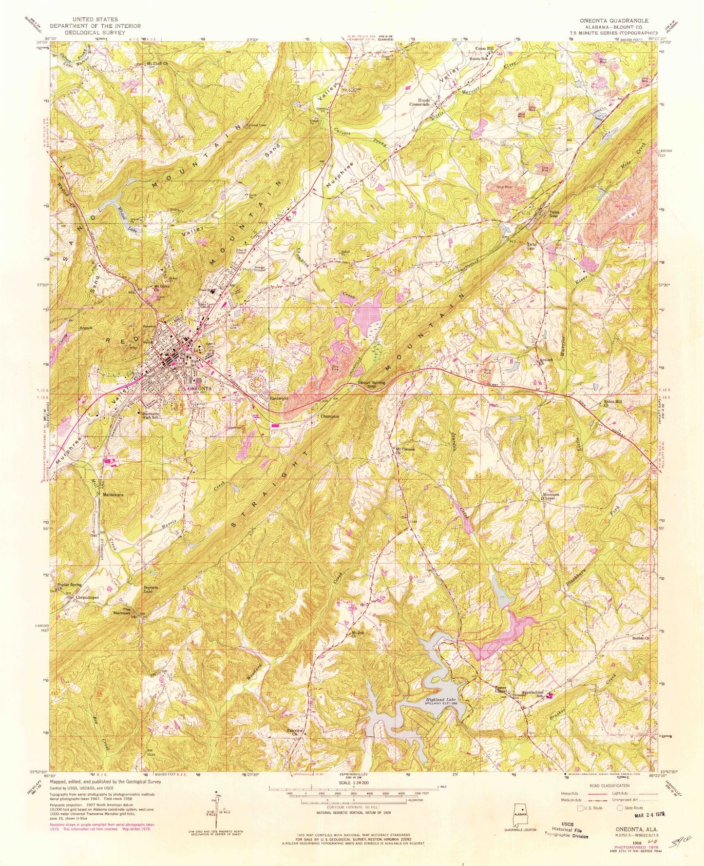
Classic USGS Oneonta Alabama 7.5'x7.5' Topo Map
Couldn't load pickup availability
Historical USGS topographic quad map of Oneonta in the state of Alabama. Typical map scale is 1:24,000, but may vary for certain years, if available. Print size: 24" x 27"
This quadrangle is in the following counties: Blount.
The map contains contour lines, roads, rivers, towns, and lakes. Printed on high-quality waterproof paper with UV fade-resistant inks, and shipped rolled.
Contains the following named places: Antioch Church, Appalachian School, Bethel Church, Brasher Creek, Champion Creek, Clements Cemetery, Eastwood, Fairview Church, Harris Creek, Highland Lake, Hoods Creek, Hoods Crossroads, Hoods School, Ingram Lake, Jourden Creek, Liberty Cemetery, Mount Carmel Church, Mount Ebell Church, Mount Joy Church, Mountain Chapel, Robin Hill Church, Rolling Fields, Sand Creek, Southside High School, Spout Spring Gap, Taits Gap, The Narrows, Whited Lake, Robbins Field, Highland Lake Dam, Sugarland Lake, Sugarland Lake Dam, McKay Lake, McKay Lake Dam, Will Engle Lake, Will Engle Dam, Doctor Pattons Lower Lake Dam, Doctor Pattons Lower Lake, Robbins Lake, Robbins Lake Dam, Whited Lake Dam, McPherson Lake, McPherson Dam, Vandegrift Pond Dam, Vandegrift Pond, Appalachian, Bennett Mine, Bethlehem United Methodist Church, First Baptist Church, Iron Mountain, Mill (historical), Mount Zion Baptist Church, Murphree, Ogee (historical), Oneonta Church of Christ, Oneonta Elementary School, Oneonta High School, Oneonta Methodist Church, Robin Coal Mines, Straight Mountain, Sugarland Lake Resort, Taits Gap Drift Mine, Valley View Cemetery, Fosters Chapel Church of God, Mount Olive Baptist Church, Oakhill Cemetery, Oneonta, Shiloh Methodist Church, Union Hill Baptist Church, Lester Memorial United Methodist Church, Champion, Chepultepec, Mattawana, Taits Gap, WCRL-AM (Oneonta), WKLD-FM (Oneonta), Apostolic Jesus Name Mission Church, Corpus Christi Church, Home Place Church, Philadelphia Baptist Church, Taits Gap Church, Oneonta Division, Murphrees Valley Post Office (historical), Oneonta Post Office, Highland Lake, Blount County Courthouse, Blount County Memorial Museum, Blount County-Oneonta Agri-Business Center, Covered Bridge Golf Course (historical), Heritage Green Golf Course, Oneonta City Hall, Oneonta Industrial Park, Oneonta Recreation Park, Whispering Pines Golf Course, Woodland Park, City of Oneonta, Town of Highland Lake, Saint Vincent's Blount Hospital, NorthStar Emergency Medical Services Blount County, Oneonta Fire Department, Murphree Valley Volunteer Fire Department, Straight Mountain Volunteer Fire Department Station 1, Blount County Sheriff's Office, Oneonta Police Department