MyTopo
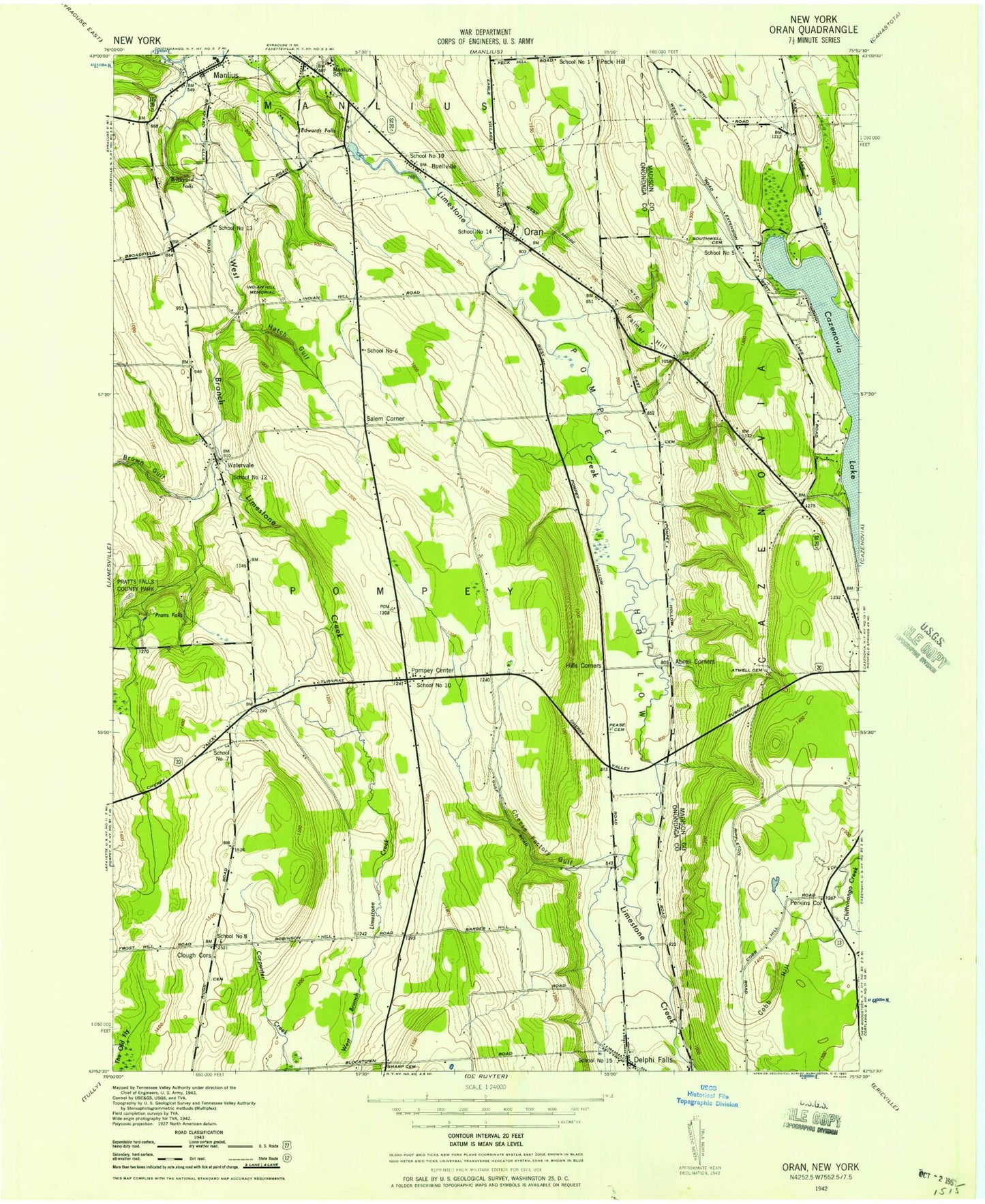
Classic USGS Oran New York 7.5'x7.5' Topo Map
Couldn't load pickup availability
Historical USGS topographic quad map of Oran in the state of New York. Typical map scale is 1:24,000, but may vary for certain years, if available. Print size: 24" x 27"
This quadrangle is in the following counties: Madison, Onondaga.
The map contains contour lines, roads, rivers, towns, and lakes. Printed on high-quality waterproof paper with UV fade-resistant inks, and shipped rolled.
Contains the following named places: Atwell Corners, Brown Gulf, Buellville, Cheese Factory Gulf, Clough Corners, Cobb Hill, Oran Community Church, Eagle Hill Middle School, Eastern Hills Bible Church, Enders Road Elementary School, Hatch Gulf, Hills Corners, Indian Hill Memorial, Manlius School (historical), Oran, Palmer Hill, Perkins Corner, Pompey Center, Pompey Hollow, Salem Corner, Watervale, West Branch Limestone Creek, Brickyard Falls, Delphi Falls, Edwards Falls, Pratts Falls, Pratts Falls County Park, Peck Hill, Wallbridge Airport (historical), Town of Pompey, School Number 8 (historical), School Number 10 (historical), School Number 12 (historical), School Number 14 (historical), School Number 15 (historical), School Number 19 (historical), Delphi Falls Park, Comstock Hall (historical), Huntington Hall (historical), Goat Hill Farm, Maple Hill Nursery, Tre-G Farms, Pompey Center Cemetery, Oran Cemetery, Delphi Falls Baptist Church Cemetery, Delphi Falls Baptist Church, Baker Cemetery, Clark Cemetery, Blocktown Cemetery, Pease Cemetery, Dodge Cemetery, Atwell Cemetery, Southwell Cemetery, School Number 5 (historical), School Number 13 (historical), School Number 6 (historical), School Number 7 (historical), School Number 1 (historical), Bethel Cemetery, Our Farm, Temperance Hill Farms, Delphi Pit, Delphi Falls Post Office, Delphi Falls Fire Department, Atwell Corners, Brown Gulf, Buellville, Cheese Factory Gulf, Clough Corners, Cobb Hill, Oran Community Church, Eagle Hill Middle School, Eastern Hills Bible Church, Enders Road Elementary School, Hatch Gulf, Hills Corners, Indian Hill Memorial, Manlius School (historical), Oran, Palmer Hill, Perkins Corner, Pompey Center, Pompey Hollow, Salem Corner, Watervale, West Branch Limestone Creek, Brickyard Falls, Delphi Falls, Edwards Falls, Pratts Falls, Pratts Falls County Park, Peck Hill, Wallbridge Airport (historical), Town of Pompey, School Number 8 (historical), School Number 10 (historical), School Number 12 (historical), School Number 14 (historical), School Number 15 (historical), School Number 19 (historical), Delphi Falls Park, Comstock Hall (historical), Huntington Hall (historical), Goat Hill Farm, Maple Hill Nursery, Tre-G Farms, Pompey Center Cemetery, Oran Cemetery, Delphi Falls Baptist Church Cemetery, Delphi Falls Baptist Church, Baker Cemetery, Clark Cemetery, Blocktown Cemetery, Pease Cemetery, Dodge Cemetery, Atwell Cemetery, Southwell Cemetery, School Number 5 (historical), School Number 13 (historical), School Number 6 (historical), School Number 7 (historical), School Number 1 (historical), Bethel Cemetery, Our Farm, Temperance Hill Farms, Delphi Pit, Delphi Falls Post Office, Delphi Falls Fire Department