MyTopo
Classic USGS Paint Rock Alabama 7.5'x7.5' Topo Map
Couldn't load pickup availability
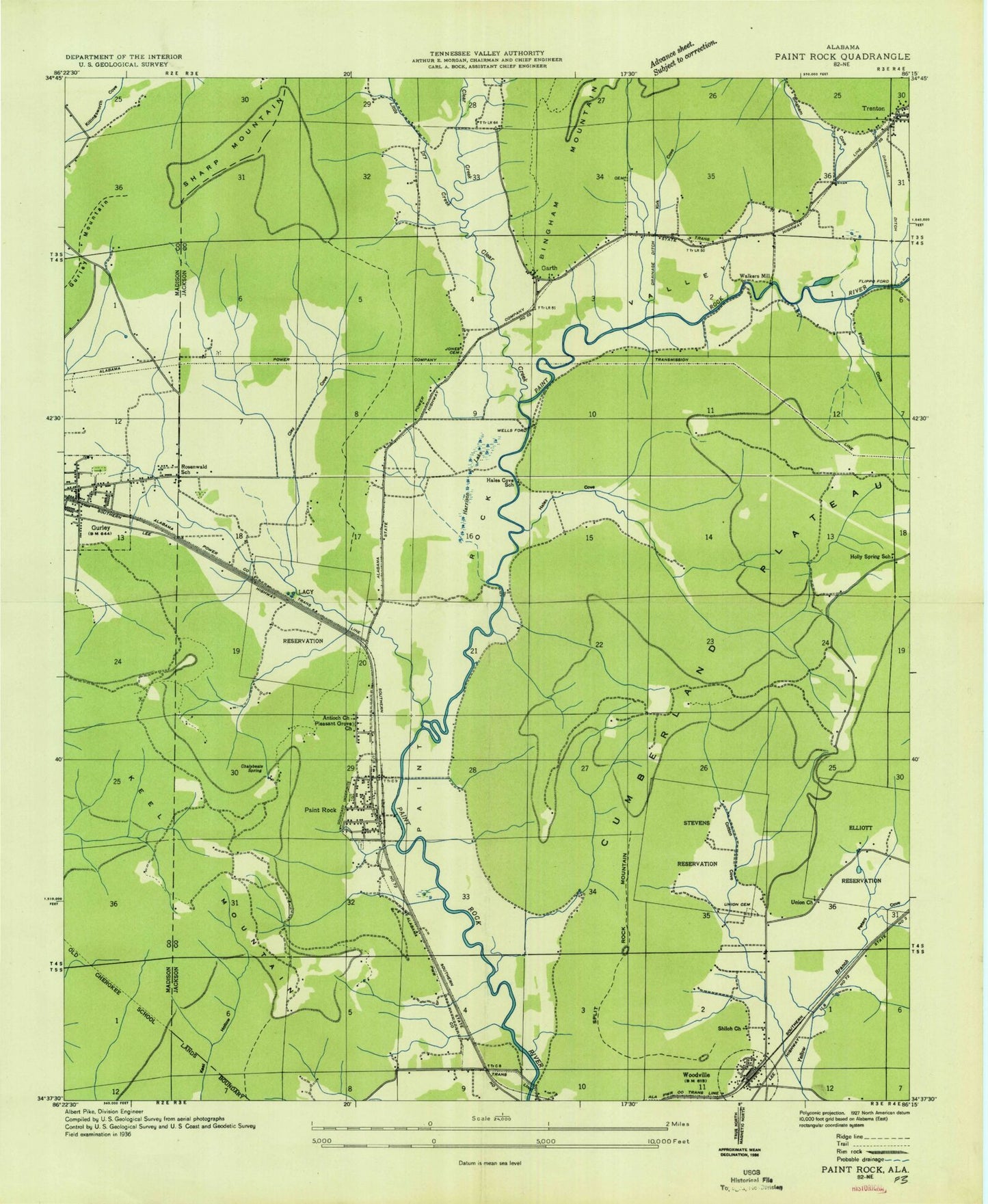
Historical USGS topographic quad map of Paint Rock in the state of Alabama. Typical map scale is 1:24,000, but may vary for certain years, if available. Print size: 24" x 27"
This quadrangle is in the following counties: Jackson, Madison.
The map contains contour lines, roads, rivers, towns, and lakes. Printed on high-quality waterproof paper with UV fade-resistant inks, and shipped rolled.
Contains the following named places: Antioch Church, Big Lake, Bingham Cove, Bingham Creek, Blair Spring, Bucks Pocket, Bullock Cemetery, Bullock Point, Butler Hollow, Chalybeate Spring, Clay Cemetery, Clay Cove, Clear Creek, Cole Spring, Cole Spring Branch, Conyers-Rosenwald School, Cotton Cove, Daniel Spring, Elliott Reservation, Finley Cove, Flanagan Cemetery, Frazier Point, Gilliam Spring, Hales Cove, High Point, Jones Cemetery, Kennamer Hollow, Kirk Cemetery, Kirk Cove, Lacy Reservation, Latham Cemetery, Laurel Branch, Little Dry Creek, Nolton Point, Paint Rock Valley, Peters Cove, Roberson Cemetery, Rousseau Cemetery, Rousseau Hollow, Shanty Branch, Shiloh Church, Smith Cemetery, Spout Spring, Stephens Cemetery, Stevens Reservation, Stewart Cemetery, Stewart Cove, Trenton, Union Cemetery, Union Church, Walker Cemetery, Webb Hollow, Woodville, Woodville School, Smith Walker and Johnson Lake, Smith Walker and Johnson Lake Dam, Antioch Church, Hales Cove School (historical), Holly Springs School (historical), Naught Mine, Serotas Spring, Smiths Mill (historical), Blue Spring, Haley Spring, Fern Cave National Wildlife Refuge, Fowler Cemetery, Garth Church, Paint Rock Cemetery, Paint Rock Church, Ross Cemetery, Rousseau Cemetery, Trenton Church, Pleasant Grove Baptist Church, Splitrock Mountain, Garth, Paint Rock, Walker Mill Ford, Wells Ford, Paint Rock Division, Flippo Ford, Holly Spring School (historical), Walkers Mill (historical), Saint Clair Grist Mill (historical), Town of Woodville, Town of Paint Rock, Keel Mountain Volunteer Fire Department, Woodville Volunteer Fire Department, Gurley Volunteer Fire Department Station 1, Paint Rock Volunteer Fire Department, Gurley Volunteer Fire Department Station 2, Valley Volunteer Fire Department Station 2, Gurley Police Department, Woodville Post Office, Paint Rock Post Office, Antioch Church, Big Lake, Bingham Cove, Bingham Creek, Blair Spring, Bucks Pocket, Bullock Cemetery, Bullock Point, Butler Hollow, Chalybeate Spring, Clay Cemetery, Clay Cove, Clear Creek, Cole Spring, Cole Spring Branch, Conyers-Rosenwald School, Cotton Cove, Daniel Spring, Elliott Reservation, Finley Cove, Flanagan Cemetery, Frazier Point, Gilliam Spring, Hales Cove, High Point, Jones Cemetery, Kennamer Hollow, Kirk Cemetery, Kirk Cove, Lacy Reservation, Latham Cemetery, Laurel Branch, Little Dry Creek, Nolton Point, Paint Rock Valley, Peters Cove, Roberson Cemetery, Rousseau Cemetery, Rousseau Hollow, Shanty Branch, Shiloh Church, Smith Cemetery, Spout Spring, Stephens Cemetery, Stevens Reservation, Stewart Cemetery, Stewart Cove, Trenton, Union Cemetery, Union Church, Walker Cemetery, Webb Hollow, Woodville, Woodville School, Smith Walker and Johnson Lake, Smith Walker and Johnson Lake Dam, Antioch Church, Hales Cove School (historical), Holly Springs School (historical), Naught Mine, Serotas Spring, Smiths Mill (historical), Blue Spring, Haley Spring, Fern Cave National Wildlife Refuge, Fowler Cemetery, Garth Church, Paint Rock Cemetery, Paint Rock Church, Ross Cemetery, Rousseau Cemetery, Trenton Church, Pleasant Grove Baptist Church, Splitrock Mountain, Garth, Paint Rock, Walker Mill Ford, Wells Ford, Paint Rock Division, Flippo Ford, Holly Spring School (historical), Walkers Mill (historical), Saint Clair Grist Mill (historical), Town of Woodville, Town of Paint Rock, Keel Mountain Volunteer Fire Department, Woodville Volunteer Fire Department, Gurley Volunteer Fire Department Station 1, Paint Rock Volunteer Fire Department, Gurley Volunteer Fire Department Station 2, Valley Volunteer Fire Department Station 2, Gurley Police Department, Woodville Post Office, Paint Rock Post Office, Antioch Church, Big Lake, Bingham Cove, Bingham Creek, Blair Spring, Bucks Pocket, Bullock Cemetery, Bullock Point, Butler Hollow, Chalybeate Spring, Clay Cemetery, Clay Cove, Clear Creek, Cole Spring, Cole Spring Branch, Conyers-Rosenwald School, Cotton Cove, Daniel Spring, Elliott Reservation, Finley Cove, Flanagan Cemetery, Frazier Point, Gilliam Spring, Hales Cove, High Point, Jones Cemetery, Kennamer Hollow, Kirk Cemetery, Kirk Cove, Lacy Reservation, Latham Cemetery, Laurel Branch, Little Dry Creek, Nolton Point, Paint Rock Valley, Peters Cove, Roberson Cemetery, Rousseau Cemetery, Rousseau Hollow, Shanty Branch, Shiloh Church, Smith Cemetery, Spout Spring, Stephens Cemetery, Stevens Reservation, Stewart Cemetery, Stewart Cove, Trenton