MyTopo
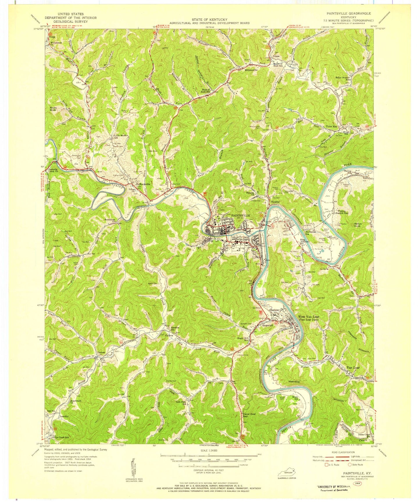
Classic USGS Paintsville Kentucky 7.5'x7.5' Topo Map
Couldn't load pickup availability
Historical USGS topographic quad map of Paintsville in the state of Kentucky. Map scale may vary for some years, but is generally around 1:24,000. Print size is approximately 24" x 27"
This quadrangle is in the following counties: Floyd, Johnson.
The map contains contour lines, roads, rivers, towns, and lakes. Printed on high-quality waterproof paper with UV fade-resistant inks, and shipped rolled.
Contains the following named places: America School, Asa Creek, B U Cabin, Baker Branch, Baker Branch Church, Barnetts Creek, Barnetts United Baptist Church, Beachwald Church, Bettys Knob, Big Lick Fork, Blackberry Branch, Blair Cemetery, Boyd Branch, Buffalo Creek, Burnt Cabin Branch, Butler Cemetery, Cannel Coal Gap, Castle Cemetery, City of Paintsville, Collista, Collista Railroad Station, Company Cemetery, Concord Church, Concord United Baptist Church, Conley Branch, Conley Cemetery, Cow Pen Hollow, Davis Branch, Davis Cemetery, Dawkins, Day Star Christian Center, Denver, Dicey Branch, Dixon Cemetery, Flat Rock Branch, Flatwood Branch, Franklin Cemetery, Gambill Cemetery, Goble Cemetery, Hager Hill Railroad Station, Hagerhill, Hagerhill Post Office, Hampton Cemetery, Hanners Branch, Happy Hollow, Highland Church, Highland Memorial Park, Horne Branch, Horne Cemetery, Hoss Mill Branch, Howes Cemetery, Jennys Creek, Johnson Cemetery, Johnson County, Johnson County Central High School, Johnson County Memorial Cemetery, Johnson County School, Johnson County Sheriff's Office, K Fork, Leander, Left Fork, Liberty Church, Lick Fork, Lick Fork Church, Lindy Branch, Line Branch, Little Lick Fork, Little Mudlick Creek, Long Branch, Lower Greasy Post Office, Lower Twin Branch, Meade Cemetery, Meally Post Office, Melvin Cemetery, Middle Fork Lick Fork, Mill Branch, Miller Creek, Muddy Branch, Mudlick Creek, Music Cemetery, Nippa, Old Preston Cemetery, Old Union Regular Baptist Church of Jesus Christ, Paint Creek, Paintsville, Paintsville / Johnson County Emergency Management, Paintsville Division, Paintsville Fire Department Station 2, Paintsville Golf Course, Paintsville Lake State Park, Paintsville Police Department, Paintsville Post Office, Paintsville-Johnson County Medical Center, Paul B Hall Regional Medical Center, Perkins Rehabilitation Center, Persimmon Point Cemetery, Porter School, Preston Branch, Preston Cemetery, Ramey Branch Church, Ratliff Cemetery, Road Fork, Rockhouse Branch, Rockhouse Church, Rockhouse Creek, Rockhouse Fire and Rescue, Rocky Knob, Rocky Knob Branch, Rush Fork, Stafford Cemetery, Staffordsville, Staffordsville Church, Staffordsville Post Office, State Branch, Stave Branch, Stonecoal Branch, Sulphur Spring Branch, Sycamore Fork, Tays Branch, Thealka, Thealka Church, Thealka Tutor Key Volunteer Fire Department, Thelma, Thelma Census Designated Place, Thelma Fire Department, Thelma Lake, Thelma Post Office, Tiny Branch, Toms Creek United Baptist Church, Tucker Branch, Turner Branch, Turner Cemetery, Tutor Key, Tutor Key Church, Upper Twin Branch, Van Lear, Van Lear Census Designated Place, Van Lear Post Office, Van Lear Volunteer Fire Department, Vanhoose Cemetery, Volga, W R Castle Memorial School, W R Castle Volunteer Fire Department, Webb Branch, Welch Cemetery, West Van Lear, West Van Lear Census Designated Place, West Van Lear Post Office, West Van Lear Volunteer Fire Department, Wheeler Cemetery, Whippoorwill Branch, Whipporwill Cemetery, White House Post Office, Whitehouse Cemetery, Williams Branch, Williams Fork, Wittensville, Wittensville Post Office, WKLW-AM (Paintsville), WSIP-AM (Paintsville), WSIP-FM (Paintsville), ZIP Codes: 41222, 41240, 41260, 41263, 41268, 41274