MyTopo
Classic USGS Palm Beach Farms Florida 7.5'x7.5' Topo Map
Couldn't load pickup availability
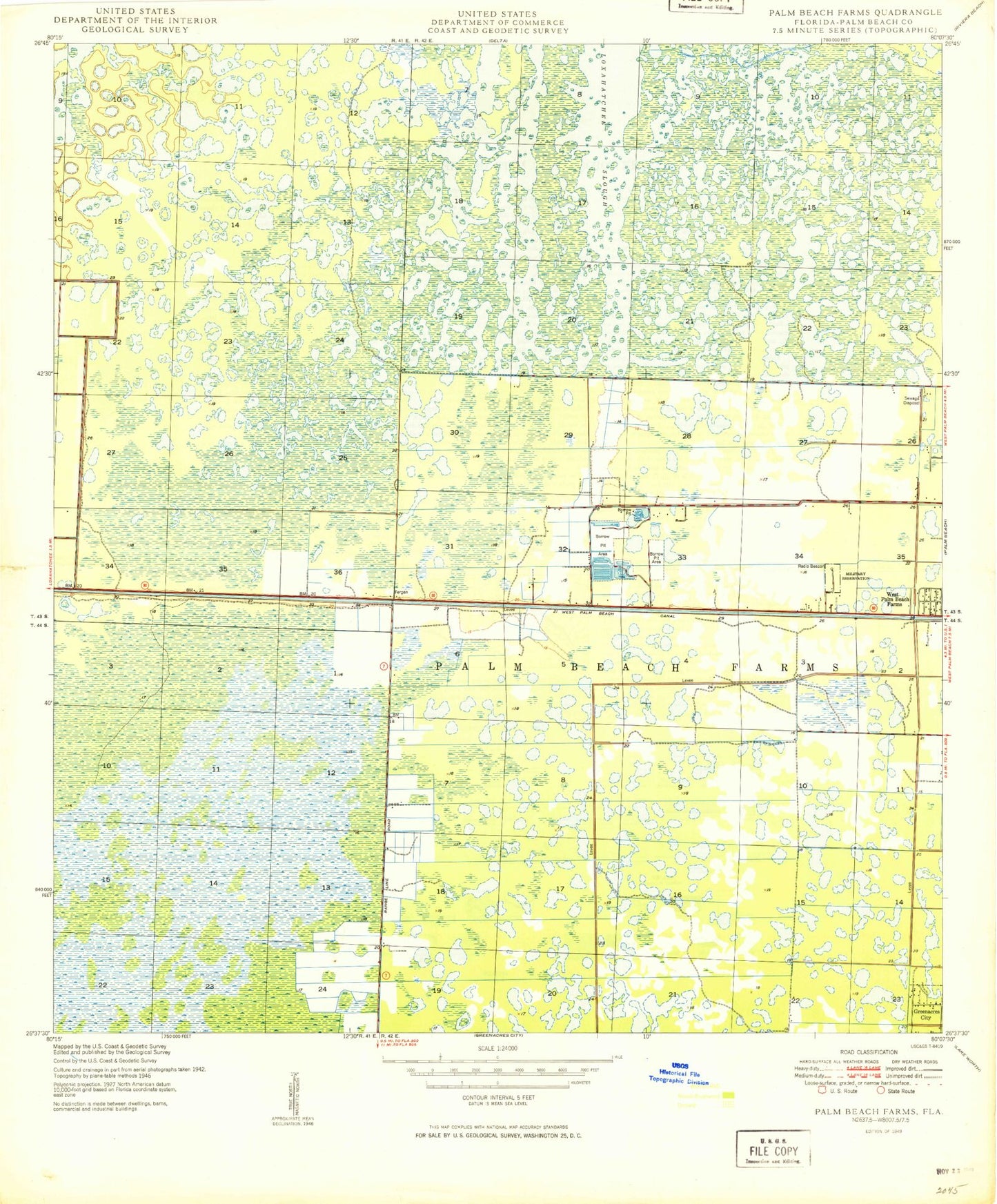
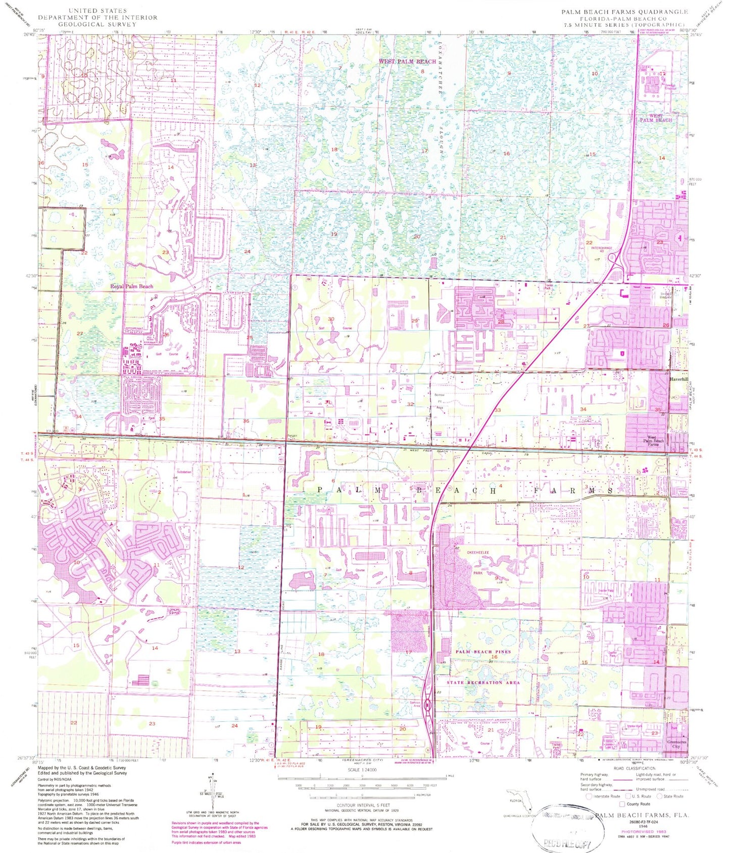
Historical USGS topographic quad map of Palm Beach Farms in the state of Florida. Map scale may vary for some years, but is generally around 1:24,000. Print size is approximately 24" x 27"
This quadrangle is in the following counties: Palm Beach.
The map contains contour lines, roads, rivers, towns, and lakes. Printed on high-quality waterproof paper with UV fade-resistant inks, and shipped rolled.
Contains the following named places: Benoist Farms Elementary School, Casa del Monte Mobile Home Resort, Century Village, Century Village Census Designated Place, Cholee Lake Elementary School, City of Greenacres, City of West Palm Beach, Crestwood Community Middle School, Cypress Trails Elementary School, Fire Station Number 23, Fire Station Number 25, Fire Station Number 28, Fire Station Number 29, Fire Station Number 34, Florida Highway Patrol - Lake Worth Troop L, Florida Highway Patrol Troop K, Forest Hill Elementary School, Golden Lakes, Golden Lakes Census Designated Place, Greenacres Department of Public Safety, Greenacres Fire Rescue Station Headquarters 94, H L Johnson Elementary School, Haverhill Baptist Day School, Holy Name of Jesus, Indian Ridge School, Lake Belvedere Estates, Lake Belvedere Estates Census Designated Place, Liberty Park Elementary School, Meadowbrook Mobile Home Park, Melaleuca Elementary School, Okeeheelee Middle School, Okeeheelee Park, Palm Beach County Fire Rescue Station 23 Headquarters, Palm Beach County Fire Rescue Station 25, Palm Beach County Fire Rescue Station 28 Headquarters, Palm Beach County Fire Rescue Station 29, Palm Beach County Fire Rescue Station 30, Palm Beach County Fire Rescue Station 34 Headquarters, Palm Beach County Fire Rescue Station 36, Palm Beach County Library System Royal Palm Beach Branch, Palm Beach County Library System Wellington Branch Library, Palm Beach County Public Library - Okeechobee Boulevard Branch, Palm Beach County Sheriff's Office District 16 Greenacres, Palm Beach County Sheriff's Office Volunteer Services Satellite Office, Palm Beach Farms, Palm Beach Pines State Recreation Area, Palm Beach Sheriffs Range Heliport, Palms West Post Office, Pickwick Mobile Home Park, Plantation Mobile Home Park, Plantation Mobile Home Park Census Designated Place, Ranger Heliport, Royal Palm Beach, Royal Palm Beach Elementary School, Royal Palm Beach High School, Royal Palm Beach Lake, Royal Palm Beach Police Department, Royal Palm Beach Post Office, Royal Palm Estates, Royal Palm Estates Census Designated Place, Summit Christian School, Sunset Golf Club, Suntree Country Club, Suwannee River Valley Golf Course, Sweetwater Country Club, Swiss Fairways, Tall Pines Country Day School, Tavares Cove Mobile Home Park, Terra Verde Country Club, Twin Lakes Mobile Home Park, Victory Baptist Christian School, Village Golf Course, Village of Royal Palm Beach, Wellington, Wellington Green Mall, Wellington Medical Center Heliport, Wellington Post Office, Wellington Regional Medical Center, West Palm Beach Country Club, West Palm Beach Farms, West Palm Beach Fire Rescue Station 7, Western Academy Charter School, WMNE - AM (Riviera Beach), WPOM-AM (Riviera Beach), Wynnebrook Elementary School, ZIP Codes: 33411, 33413, 33414, 33415