MyTopo
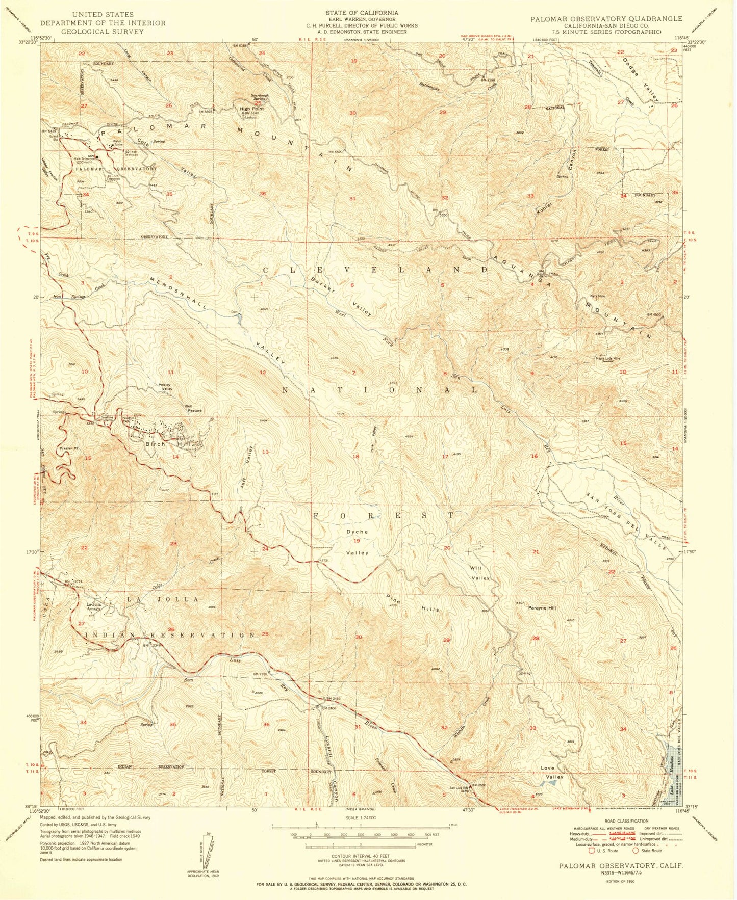
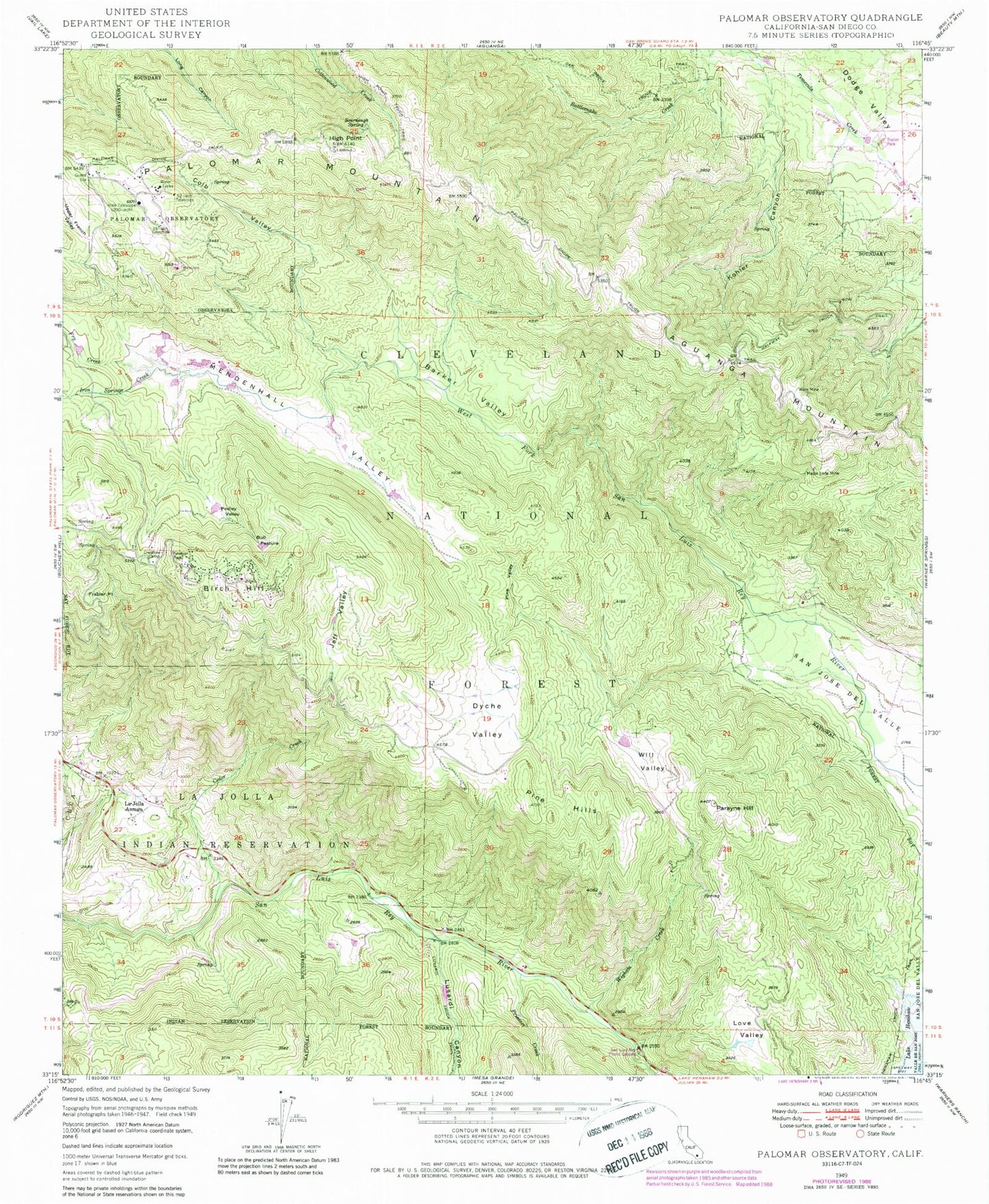
Classic USGS Palomar Observatory California 7.5'x7.5' Topo Map
Couldn't load pickup availability
Historical USGS topographic quad map of Palomar Observatory in the state of California. Typical map scale is 1:24,000, but may vary for certain years, if available. Print size: 24" x 27"
This quadrangle is in the following counties: San Diego.
The map contains contour lines, roads, rivers, towns, and lakes. Printed on high-quality waterproof paper with UV fade-resistant inks, and shipped rolled.
Contains the following named places: Bull Pasture, Kohler Canyon, Barker Valley, Barker Valley Spur, Birch Hill, Cedar Creek, Colb Valley, Crestline Camp, Dyche Valley, Frazier Point, Fry Creek, Halfway Truck Trail, Henshaw Truck Trail, High Point, Iron Springs Creek, Jeff Valley, Love Valley, Lusardi Canyon, Maple Lode Mine, Mendenhall Valley, Oak Grove Truck Trail, Palomar Divide Truck Trail, Palomar Mountain, Palomar Park, Parayne Hill, Pedley Valley, Pine Hills, Pine Valley, Prisoner Creek, San Luis Rey Camp, Sourdough Spring, Ware Mine, Wigham Creek, Will Valley, Palomar Fire Station, High Point Lookout, Barker Valley Trail, Eighteen-Inch Telescope, Fifty-Two Inch Telescope, Hale Telescope, Palomar Observatory, Aguanga Mountain, La Jolla Amago, West Fork Conservation Camp, La Jolla Recreation Site, Grammer Ranch (historical), San Luis Rey Picnic Ground, Henshaw Wildlife Viewing Site, Palomar Mountain Interpretive Site, Palomar Fire Station 79, Palomar Mountain Post Office, Bull Pasture, Kohler Canyon, Barker Valley, Barker Valley Spur, Birch Hill, Cedar Creek, Colb Valley, Crestline Camp, Dyche Valley, Frazier Point, Fry Creek, Halfway Truck Trail, Henshaw Truck Trail, High Point, Iron Springs Creek, Jeff Valley, Love Valley, Lusardi Canyon, Maple Lode Mine, Mendenhall Valley, Oak Grove Truck Trail, Palomar Divide Truck Trail, Palomar Mountain, Palomar Park, Parayne Hill, Pedley Valley, Pine Hills, Pine Valley, Prisoner Creek, San Luis Rey Camp, Sourdough Spring, Ware Mine, Wigham Creek, Will Valley, Palomar Fire Station, High Point Lookout, Barker Valley Trail, Eighteen-Inch Telescope, Fifty-Two Inch Telescope, Hale Telescope, Palomar Observatory, Aguanga Mountain, La Jolla Amago, West Fork Conservation Camp, La Jolla Recreation Site, Grammer Ranch (historical), San Luis Rey Picnic Ground, Henshaw Wildlife Viewing Site, Palomar Mountain Interpretive Site, Palomar Fire Station 79, Palomar Mountain Post Office