MyTopo
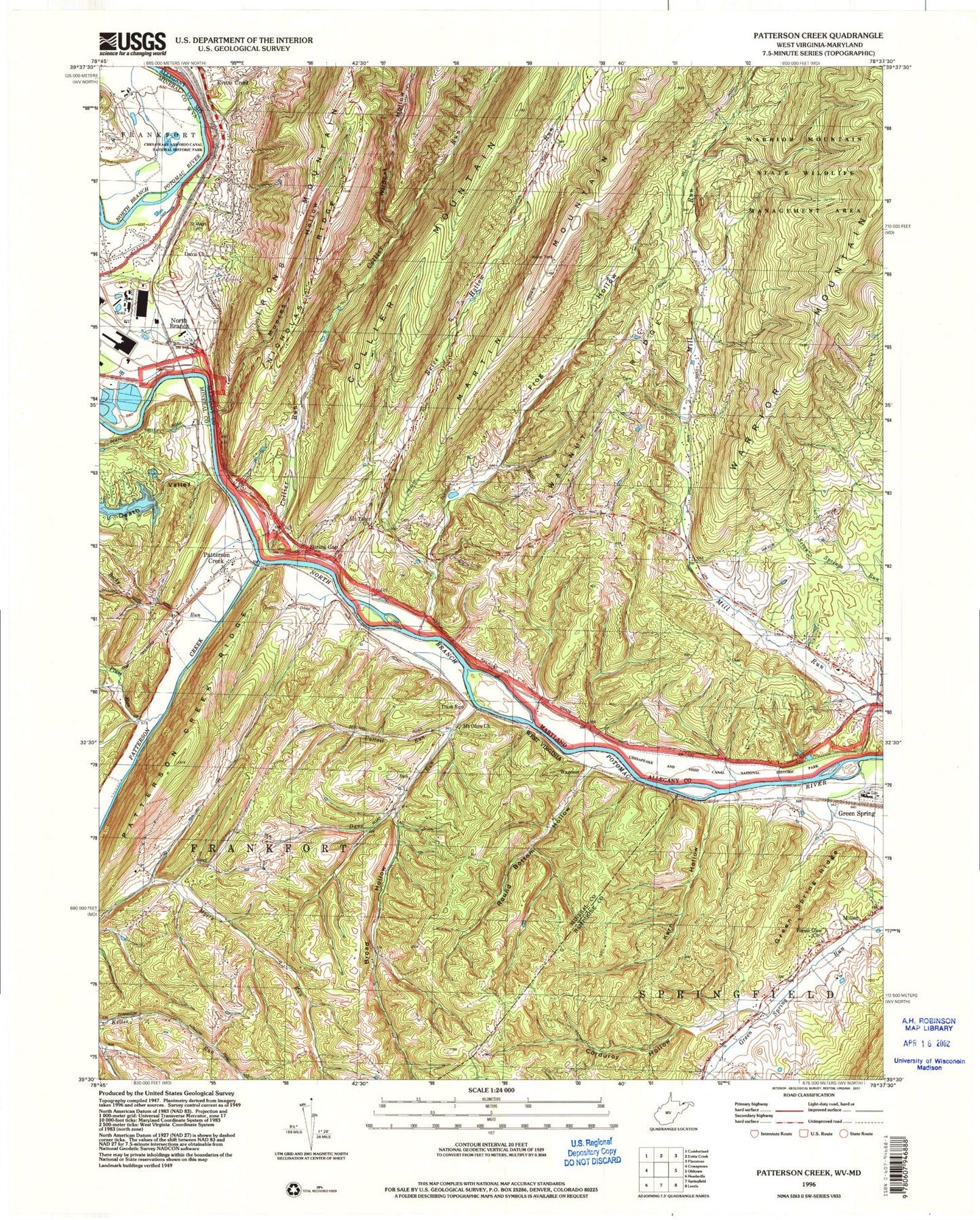
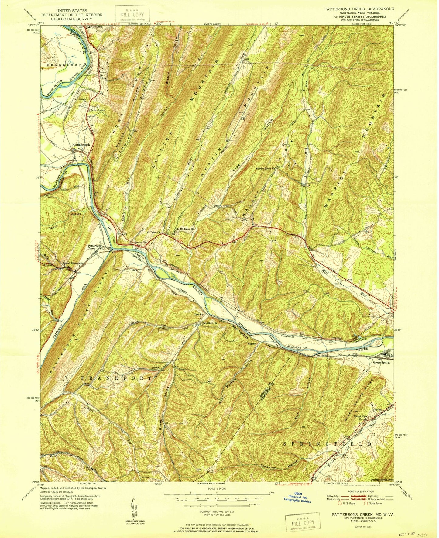
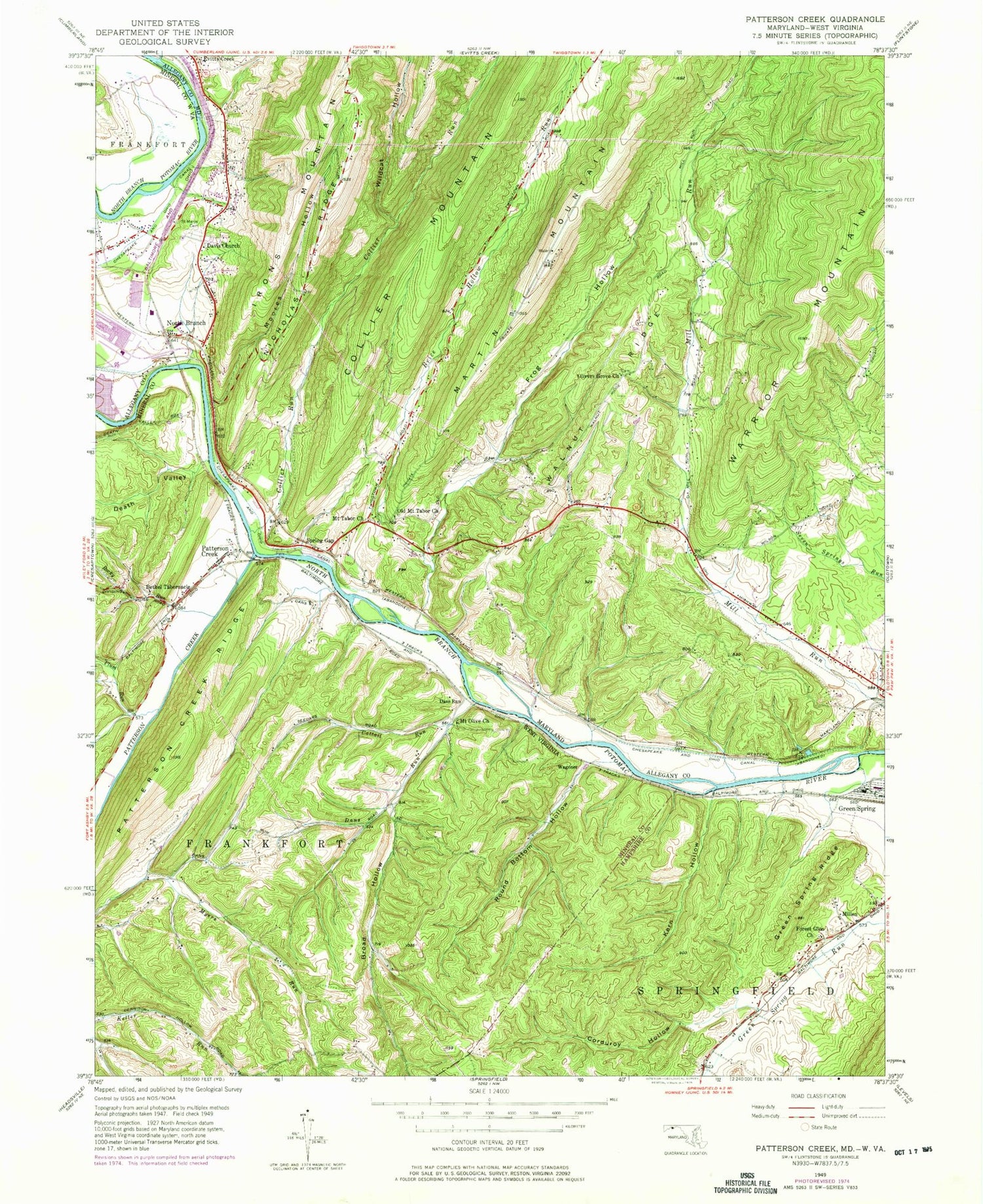
Classic USGS Patterson Creek West Virginia 7.5'x7.5' Topo Map
Couldn't load pickup availability
Historical USGS topographic quad map of Patterson Creek in the states of West Virginia, Maryland. Typical map scale is 1:24,000, but may vary for certain years, if available. Print size: 24" x 27"
This quadrangle is in the following counties: Allegany, Hampshire, Mineral.
The map contains contour lines, roads, rivers, towns, and lakes. Printed on high-quality waterproof paper with UV fade-resistant inks, and shipped rolled.
Contains the following named places: Bethel Tabernacle, Broad Hollow, Cattail Run, Corduroy Hollow, Dans Run, Death Valley, Forest Glen Church, Green Spring Ridge, Kern Hollow, Millen, Mount Olive Church, Patterson Creek, Patterson Creek Ridge, Plum Run, Rocky Run, Round Bottom Hollow, Dans Run, Patterson Creek, Wagoner, Hardy Cemetery, Methodist Cemetery, Patterson Creek Volunteer Fire Department, Green Spring Census Designated Place, Rocky Run Bridge, Forest Glen United Methodist Church Cemetery, Brice Hollow Run, Collier Mountain, Collier Run, Davis Memorial United Methodist Church, Evitts Creek, Frog Hollow, Moores Hollow, Mount Tabor United Methodist Church, Nicholas Ridge, North Branch, Old Mount Tabor Church, Olivers Grove Church, Saint Marys Cemetery, Walnut Ridge, Wildcat Hollow, Evitts Creek, Spring Gap, Iron Mountain Campground, Lock 72, Lock 73, Lock 74, Mexico, North Branch Picnic Area, North Branch Visitors Center, Pigmans Ferry Campground, Spring Gap Campground, Spring Gap Post Office, Wesleyan Memorial Park, Allegany County, Blue Spring, District 16 North Branch, Warrior Mountain State Wildlife Management Area, Maryland State Police - Barrack C Cumberland, District 16 Volunteer Fire Department, Spring Gap Census Designated Place, Bethel Tabernacle, Broad Hollow, Cattail Run, Corduroy Hollow, Dans Run, Death Valley, Forest Glen Church, Green Spring Ridge, Kern Hollow, Millen, Mount Olive Church, Patterson Creek, Patterson Creek Ridge, Plum Run, Rocky Run, Round Bottom Hollow, Dans Run, Patterson Creek, Wagoner, Hardy Cemetery, Methodist Cemetery, Patterson Creek Volunteer Fire Department, Green Spring Census Designated Place, Rocky Run Bridge, Forest Glen United Methodist Church Cemetery, Brice Hollow Run, Collier Mountain, Collier Run, Davis Memorial United Methodist Church, Evitts Creek, Frog Hollow, Moores Hollow, Mount Tabor United Methodist Church, Nicholas Ridge, North Branch, Old Mount Tabor Church, Olivers Grove Church, Saint Marys Cemetery, Walnut Ridge, Wildcat Hollow, Evitts Creek, Spring Gap, Iron Mountain Campground, Lock 72, Lock 73, Lock 74, Mexico, North Branch Picnic Area, North Branch Visitors Center, Pigmans Ferry Campground, Spring Gap Campground, Spring Gap Post Office, Wesleyan Memorial Park, Allegany County, Blue Spring, District 16 North Branch, Warrior Mountain State Wildlife Management Area, Maryland State Police - Barrack C Cumberland, District 16 Volunteer Fire Department, Spring Gap Census Designated Place