
MyTopo
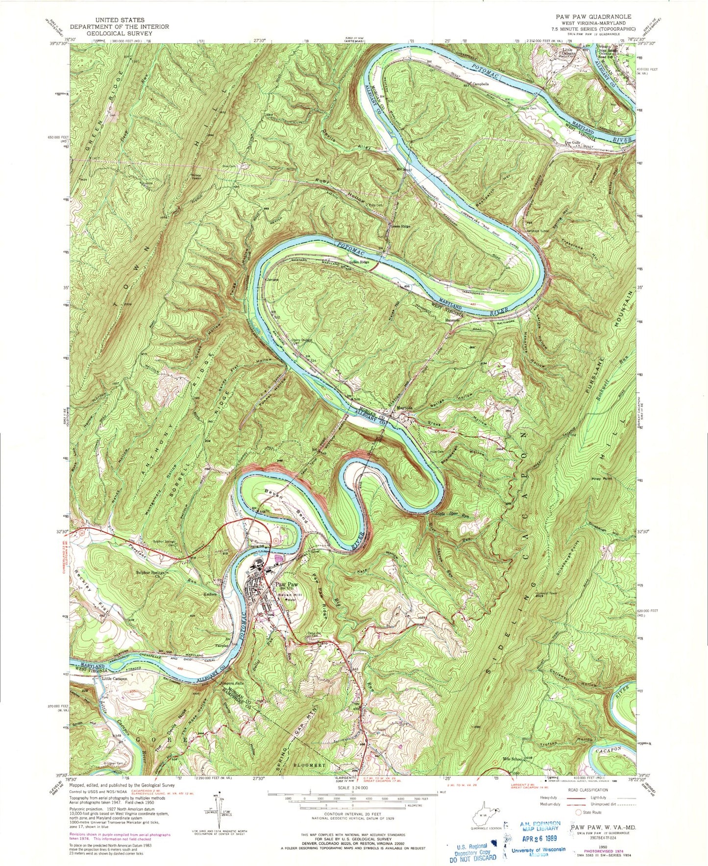
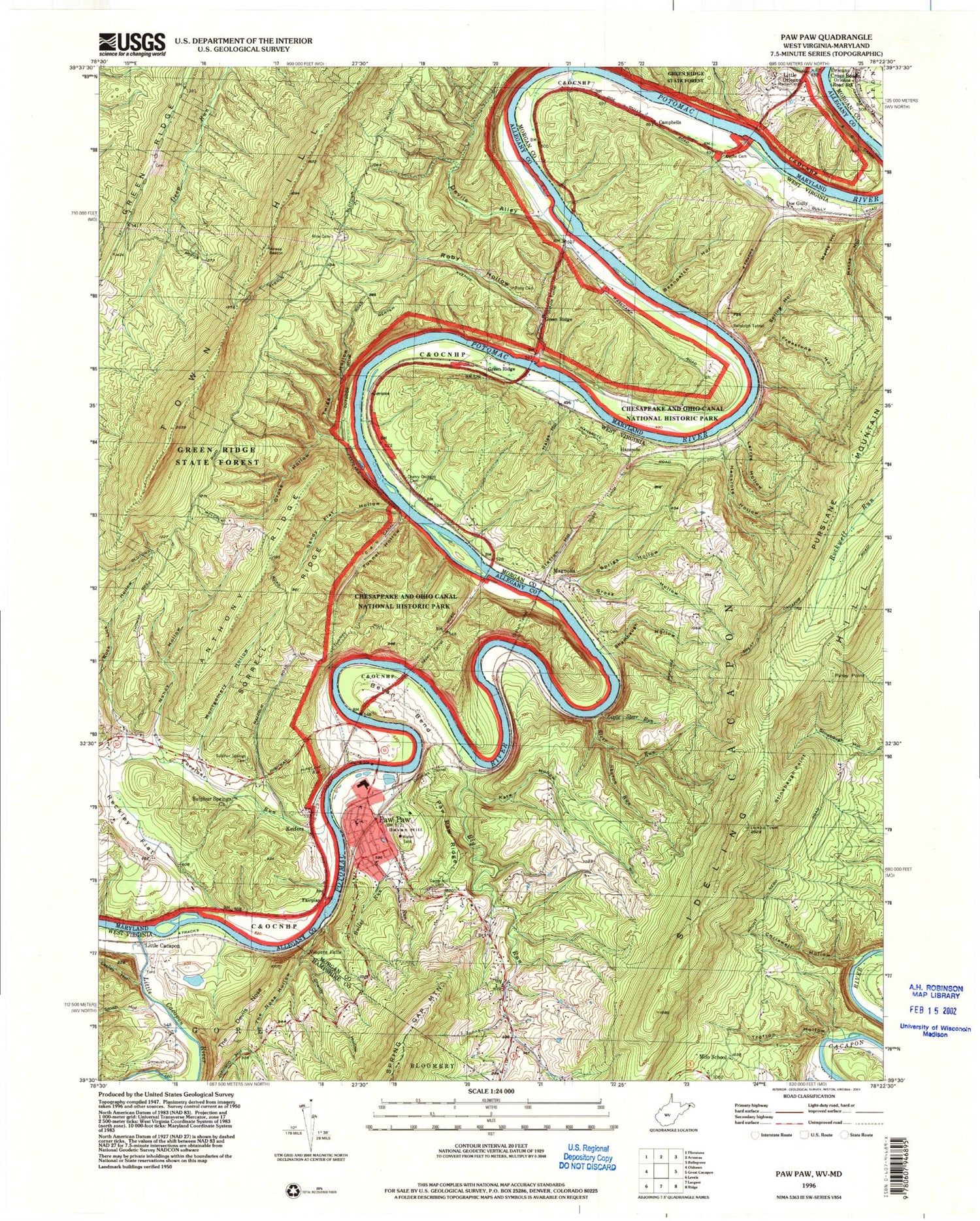
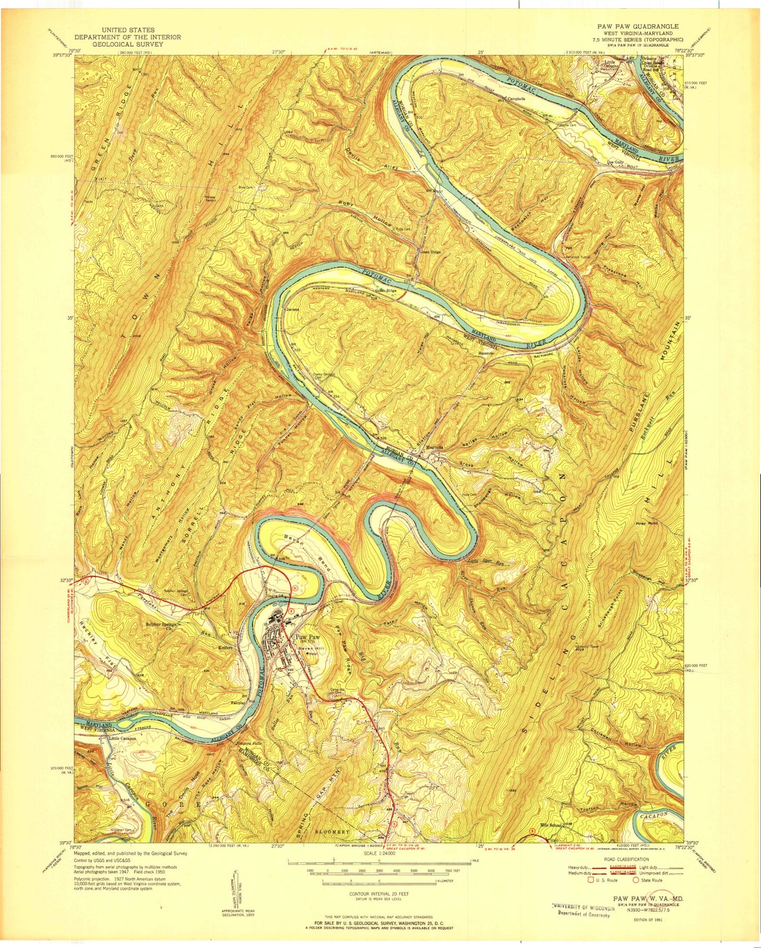
Classic USGS Paw Paw West Virginia 7.5'x7.5' Topo Map
Couldn't load pickup availability
Historical USGS topographic quad map of Paw Paw in the states of West Virginia, Maryland. Typical map scale is 1:24,000, but may vary for certain years, if available. Print size: 24" x 27"
This quadrangle is in the following counties: Allegany, Hampshire, Morgan.
The map contains contour lines, roads, rivers, towns, and lakes. Printed on high-quality waterproof paper with UV fade-resistant inks, and shipped rolled.
Contains the following named places: Beanpatch Hollow, Bevan Bend, Big Run, Bullet Run, Camp Hill Cemetery, Carothers Tunnel, Cherry Orchard Cemetery, Chriswell Hollow, Dawson Run, Dyche Cemetery, Freestone Hollow, Ginnevan Cemetery, Gross Hollow, Hales Hollow, Hansrote Hollow, Horn Cemetery, Kate Hollow, Lapley Hollow, Larrys Hollow, Little Cacapon River, Little Steer Run, Macks Hollow, Marts Hollow, Milo School (historical), Niagara Falls, Orleans Road Station, Paw Paw, Paw Paw Ridge, Piney Point, Randolph Tunnel, Shambaugh Hollow, Shanty Hollow, Sharon Run, Smith Hollow, Sprigs Hollow, Spring Hollow, Station Hollow, Steer Run, Stinebaugh Point, Stuart Tunnel, The Devils Nose, The Nose Hollow, Trofton Hollow, Campbells, Green Ridge, Bevan Hill, Doe Gully, Hansrote, Jerome, Little Cacapon, Magnolia, Orleans Cross Roads, Magnolia School (historical), Paw Paw Elementary School, Paw Paw High School, Robert Milborn Spring, Sideling Hill Lookout Tower, Bevans Cemetery, Paw Paw Post Office, Town of Paw Paw, Paw Paw Volunteer Fire and Rescue Company, PFC Ray W Stotler Memorial Bridge, Paw Paw Public Library, Paw Paw Police Department, Anthony Ridge, Devils Alley, Fifteenmile Creek, Graham Tunnel, Green Ridge, Gross Hollow, Kesler Tunnel, Martin Cemetery, Montgomery Hollow, Nancy Hollow, Purslane Run, Reckley Flat, Rine Cemetery, Roby Cemetery, Roby Hollow, Rock Lick Hollow, Sandy Flat Hollow, Sorrell Ridge, Stickpile Tunnel, Sulphur Springs Cemetery, Sulphur Springs United Methodist Church, Tunnel Hollow, Fairplay, Green Ridge, Keifers, Devils Alley Campground, Fifteen Mile Creek Aqueduct, Fifteen Mile Creek Campground, Lock 58, Lock 59, Lock 60, Lock 61, Paw Paw Bends, Paw Paw Tunnel, Pursalne Run Campground, Beanpatch Hollow, Bevan Bend, Big Run, Bullet Run, Camp Hill Cemetery, Carothers Tunnel, Cherry Orchard Cemetery, Chriswell Hollow, Dawson Run, Dyche Cemetery, Freestone Hollow, Ginnevan Cemetery, Gross Hollow, Hales Hollow, Hansrote Hollow, Horn Cemetery, Kate Hollow, Lapley Hollow, Larrys Hollow, Little Cacapon River, Little Steer Run, Macks Hollow, Marts Hollow, Milo School (historical), Niagara Falls, Orleans Road Station, Paw Paw, Paw Paw Ridge, Piney Point, Randolph Tunnel, Shambaugh Hollow, Shanty Hollow, Sharon Run, Smith Hollow, Sprigs Hollow, Spring Hollow, Station Hollow, Steer Run, Stinebaugh Point, Stuart Tunnel, The Devils Nose, The Nose Hollow, Trofton Hollow, Campbells, Green Ridge, Bevan Hill, Doe Gully, Hansrote, Jerome, Little Cacapon, Magnolia, Orleans Cross Roads, Magnolia School (historical), Paw Paw Elementary School, Paw Paw High School, Robert Milborn Spring, Sideling Hill Lookout Tower, Bevans Cemetery, Paw Paw Post Office, Town of Paw Paw, Paw Paw Volunteer Fire and Rescue Company, PFC Ray W Stotler Memorial Bridge, Paw Paw Public Library, Paw Paw Police Department, Anthony Ridge, Devils Alley, Fifteenmile Creek, Graham Tunnel, Green Ridge, Gross Hollow, Kesler Tunnel, Martin Cemetery, Montgomery Hollow, Nancy Hollow, Purslane Run, Reckley Flat, Rine Cemetery, Roby Cemetery, Roby Hollow, Rock Lick Hollow, Sandy Flat Hollow, Sorrell Ridge, Stickpile Tunnel, Sulphur Springs Cemetery, Sulphur Springs United Methodist Church, Tunnel Hollow, Fairplay, Green Ridge, Keifers, Devils Alley Campground, Fifteen Mile Creek Aqueduct, Fifteen Mile Creek Campground, Lock 58, Lock 59, Lock 60, Lock 61, Paw Paw Bends, Paw Paw Tunnel, Pursalne Run Campground