MyTopo
Classic USGS Pecks Pond Pennsylvania 7.5'x7.5' Topo Map
Couldn't load pickup availability
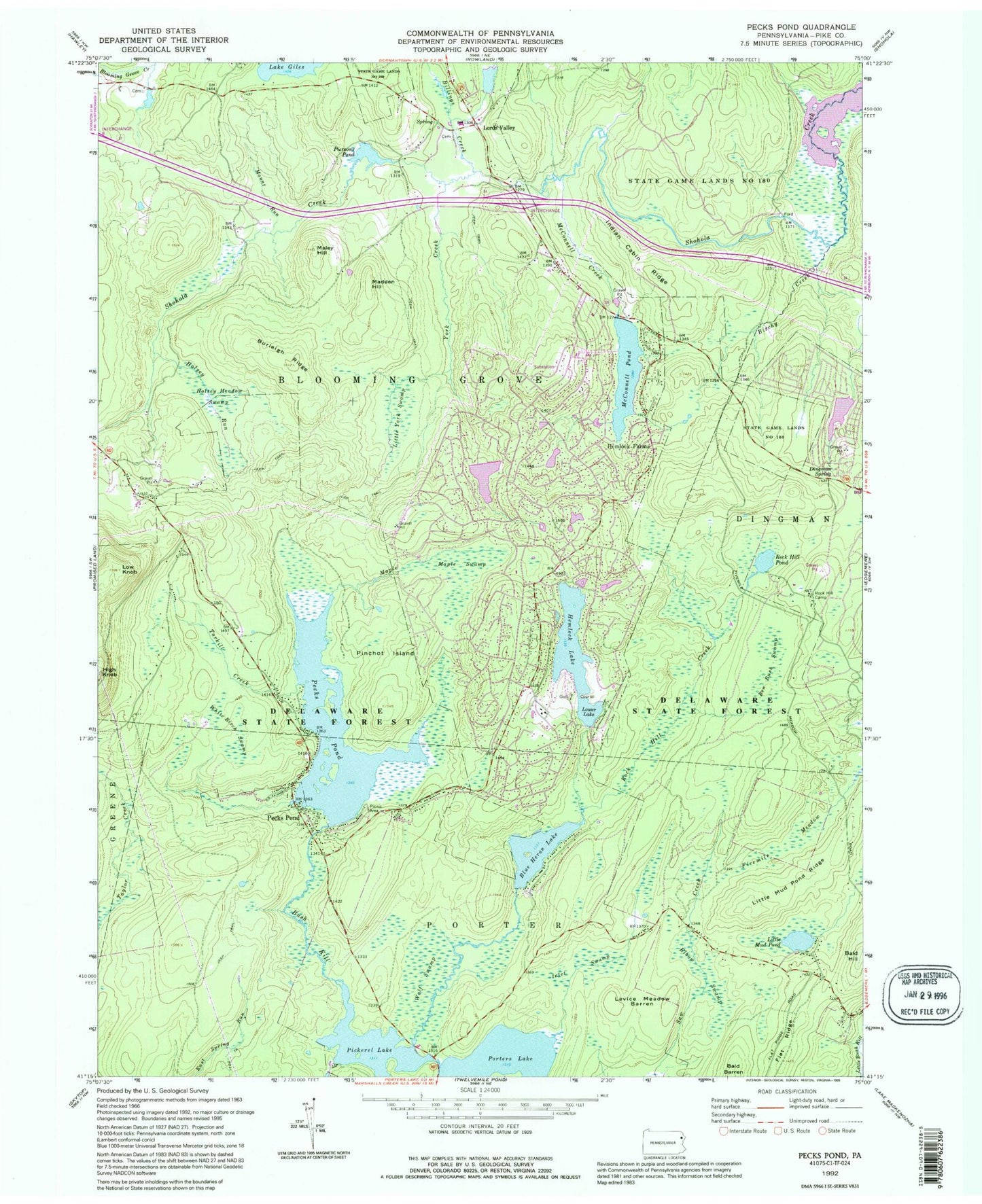
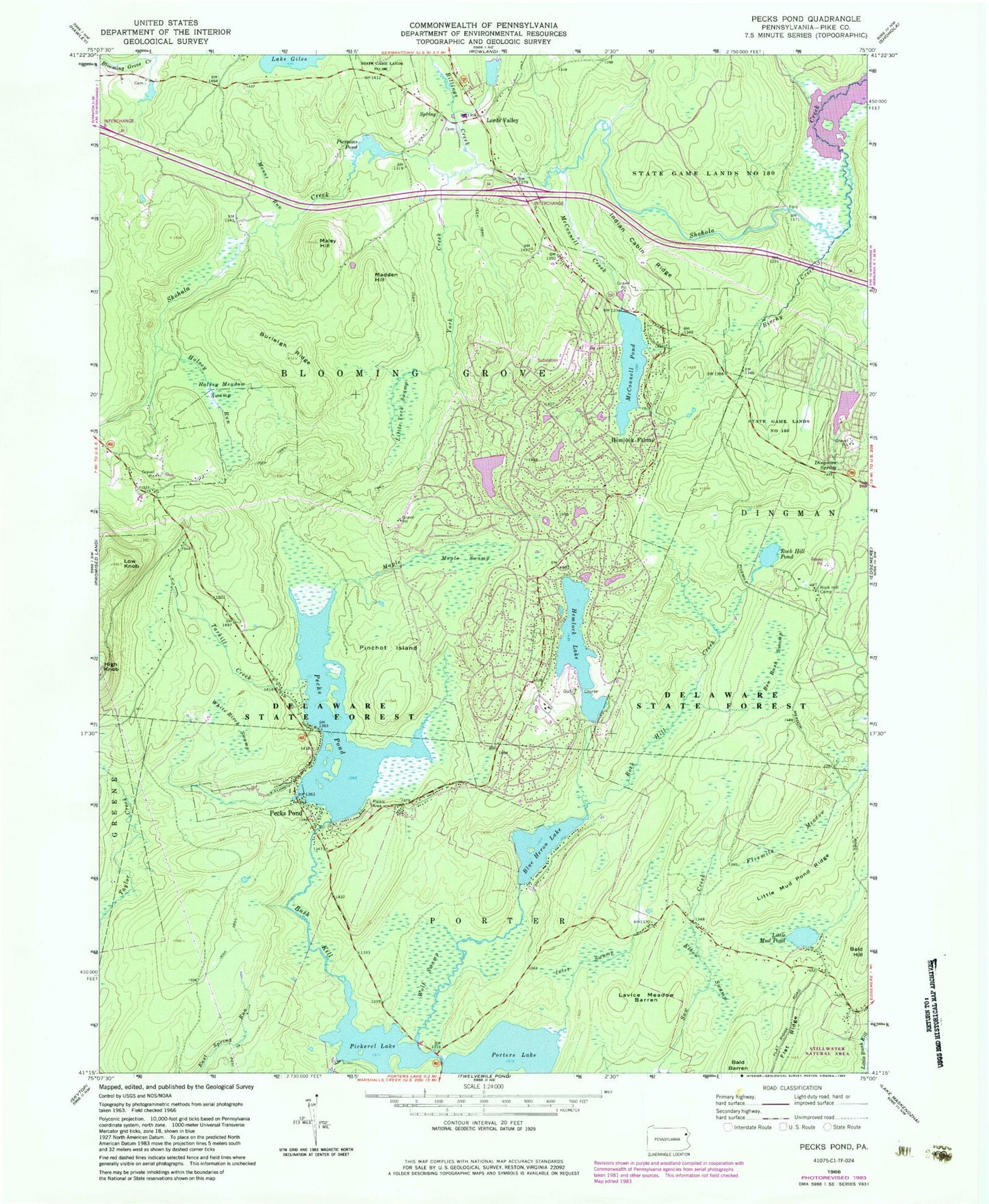
Historical USGS topographic quad map of Pecks Pond in the state of Pennsylvania. Typical map scale is 1:24,000, but may vary for certain years, if available. Print size: 24" x 27"
This quadrangle is in the following counties: Pike.
The map contains contour lines, roads, rivers, towns, and lakes. Printed on high-quality waterproof paper with UV fade-resistant inks, and shipped rolled.
Contains the following named places: Bald Hill, Ben Bush Swamp, Billings Creek, Birchy Creek, Blue Heron Lake, Burleigh Ridge, Dingman Spring, Elbow Swamp, Fivemile Meadow, Flat Ridge, Hemlock Farms, Hemlock Lake, High Knob, Holsey Meadow Swamp, Holsey Run, Indian Cabin Ridge, Inlet Swamp, Lavice Meadow Barren, Little Mud Pond, Little Mud Pond Ridge, Little York Swamp, Lords Valley, Low Knob, Madden Hill, Maley Hill, Maple Creek, Maple Swamp, McConnell Creek, McConnell Pond, Mount Run, Pecks Pond, Pecks Pond, Persons Pond, Pinchot Island, Rock Hill, Rock Hill Camp, Rock Hill Pond, Tarkill Creek, White Birch Swamp, Wolf Swamp, York Creek, Pickerel Lake, Porters Lake, Porters Lake Dam, Pickeral Pond Dam, Dorys Dam, Pecks Pond Dam, Lower Hemlock Dam, Lower Hemlock Lake, Hemlock Lake Dam, Elm Lake, Mcconnell Lake Dam, State Game Lands Number 180, Tarkill Demonstration Area, Rock Hill Creek, Smith Trail, Flat Ridge Trail, Camp Biff Trail, Kinney Trail, Pecks Pond Picnic Area, McConnell Lake Dam, Hemlock Pond Dam, Pierson Dam, Westbrook Estate Dam, High Knob Fire Tower, Pike County, Township of Blooming Grove, Pecks Pond Post Office (historical), Hemlock Farms Census Designated Place, Hemlock Farms Volunteer Fire and Rescue Company 29, Blooming Grove Fire Department 25, Ledgeway Pond, Bald Hill, Ben Bush Swamp, Billings Creek, Birchy Creek, Blue Heron Lake, Burleigh Ridge, Dingman Spring, Elbow Swamp, Fivemile Meadow, Flat Ridge, Hemlock Farms, Hemlock Lake, High Knob, Holsey Meadow Swamp, Holsey Run, Indian Cabin Ridge, Inlet Swamp, Lavice Meadow Barren, Little Mud Pond, Little Mud Pond Ridge, Little York Swamp, Lords Valley, Low Knob, Madden Hill, Maley Hill, Maple Creek, Maple Swamp, McConnell Creek, McConnell Pond, Mount Run, Pecks Pond, Pecks Pond, Persons Pond, Pinchot Island, Rock Hill, Rock Hill Camp, Rock Hill Pond, Tarkill Creek, White Birch Swamp, Wolf Swamp, York Creek, Pickerel Lake, Porters Lake, Porters Lake Dam, Pickeral Pond Dam, Dorys Dam, Pecks Pond Dam, Lower Hemlock Dam, Lower Hemlock Lake, Hemlock Lake Dam, Elm Lake, Mcconnell Lake Dam, State Game Lands Number 180, Tarkill Demonstration Area, Rock Hill Creek, Smith Trail, Flat Ridge Trail, Camp Biff Trail, Kinney Trail, Pecks Pond Picnic Area, McConnell Lake Dam, Hemlock Pond Dam, Pierson Dam, Westbrook Estate Dam, High Knob Fire Tower, Pike County, Township of Blooming Grove, Pecks Pond Post Office (historical), Hemlock Farms Census Designated Place, Hemlock Farms Volunteer Fire and Rescue Company 29, Blooming Grove Fire Department 25, Ledgeway Pond