
MyTopo
Classic USGS Pennington New Jersey 7.5'x7.5' Topo Map
Couldn't load pickup availability
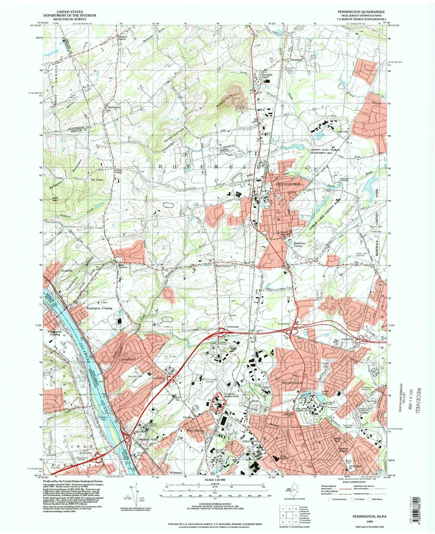
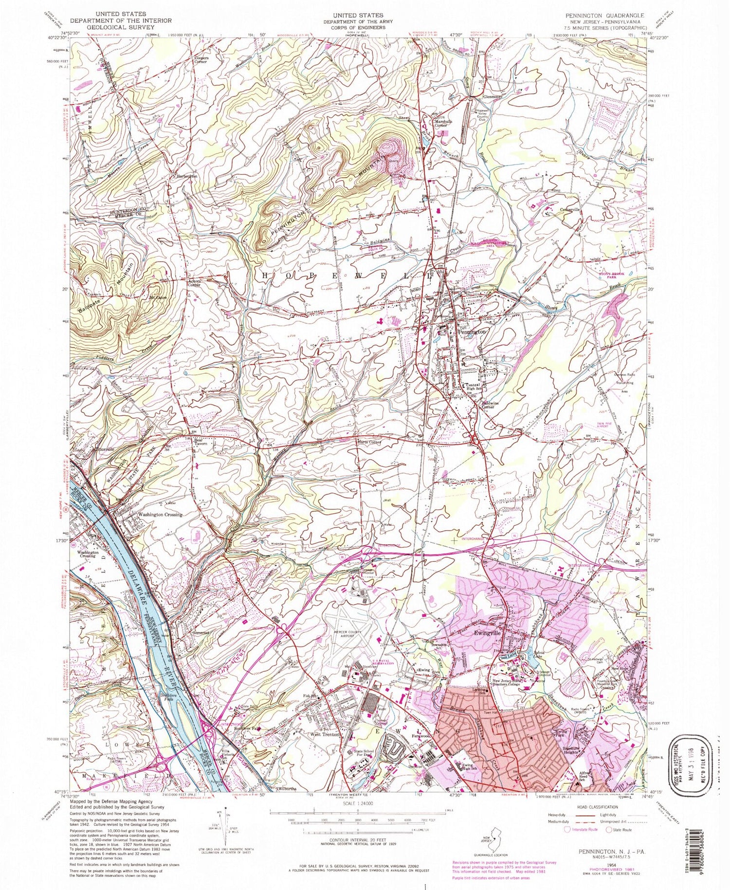
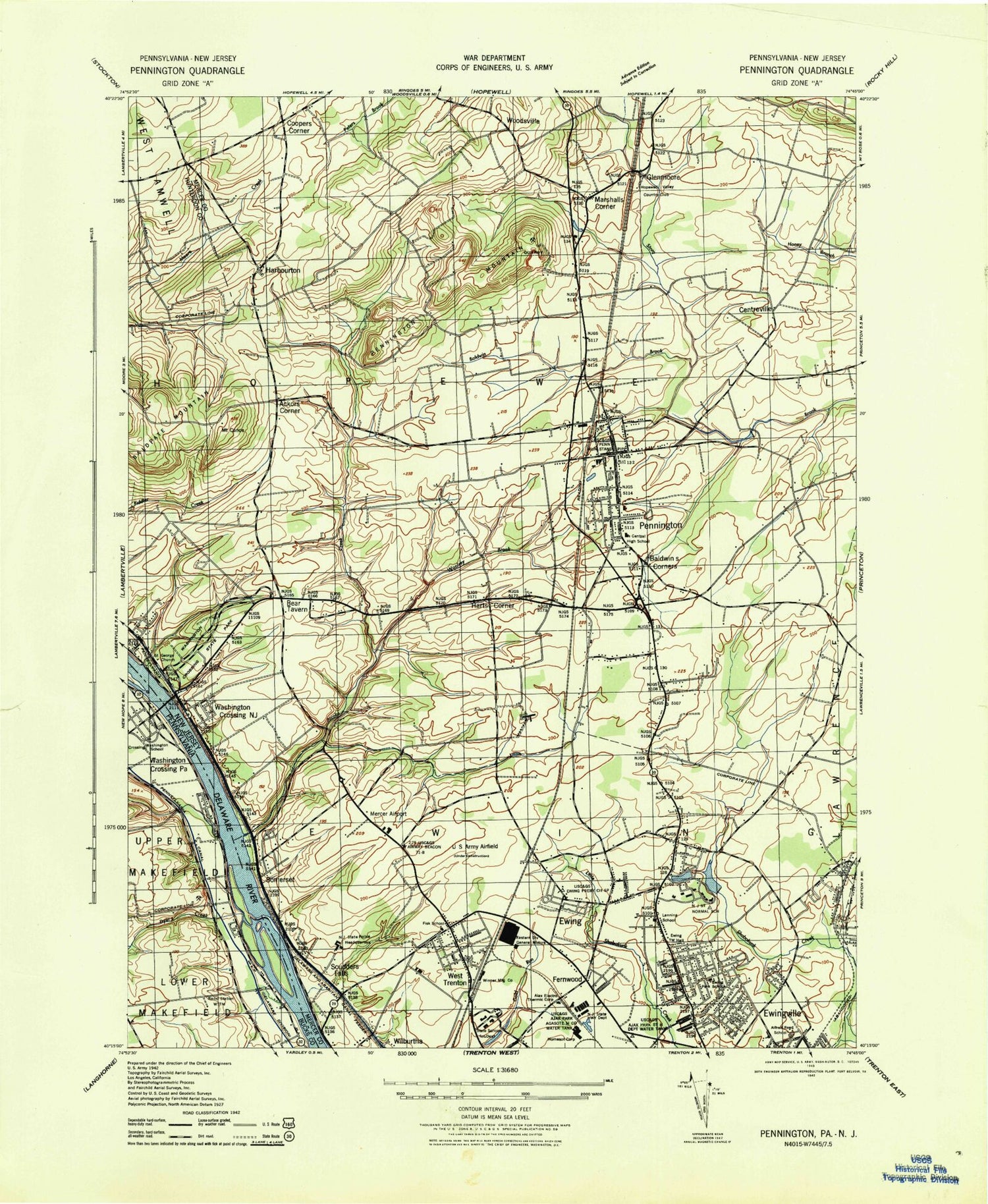
Historical USGS topographic quad map of Pennington in the states of New Jersey, Pennsylvania. Typical map scale is 1:24,000, but may vary for certain years, if available. Print size: 24" x 27"
This quadrangle is in the following counties: Bucks, Hunterdon, Mercer.
The map contains contour lines, roads, rivers, towns, and lakes. Printed on high-quality waterproof paper with UV fade-resistant inks, and shipped rolled.
Contains the following named places: Ackers Corner, Alfred Reed School, Baldpate Mountain, Baldwins Corner, Baldwins Creek, Bear Tavern, Braeburn Heights, Mount Canoe, Centerville, Central High School (historical), Ceva Lake, Coopers Corner, Ewing, Ewing Church Cemetery, Ewing High School, Ewing Park, Ewingville, Fernwood, Fisk School, Fountain Lawn Memorial Park, Glenmoore, Harbourton, Harts Corner, Jacobs Creek, Lanning School, Lewis Brook, Marshalls Corner, New Hope Church, The College of New Jersey, Pennington, Pennington Mountain, Saint Hedwigs Cemetery, Scudders Falls, Somerset, Stony Brook Branch, Sylva Lake, Villa Victoria Academy School, Washington Crossing, Washington Crossing State Park, West Trenton, Wilburtha, Woolsey Brook, Township of Ewing, Township of Hopewell, Ksayian (historical), Ewing Complex (historical), Moody Park, Rosedale Park, Heath Manor, Parkway Village, Green Curve Heights, Ferry Road Manor, West Trenton Station, Altura, Curlis Lake, Sylva Lake Dam, Ceva Lake Dam, Hopewell Valley Country Club, Department of Transportation (historical), Twin Pine Airport (historical), Weidel/Private Airport, Trenton Mercer Airport, WBUD-AM (Trenton), Borough of Pennington, State Cemetery, New Jersey School for the Deaf Katzenbach Campus, Banchoff Park, Baldwin State Park, Baldwin State Wildlife Management Area, Old Mill Road County Park, Curlis Lake County Park, Armstrong Park, Rosedale Lake, Pennington Fire Company, Bloomberg Office Complex, Ewing Business Park, Mountain View Golf Course, MountainView Office Park, Pennington Shopping Center, Princeton Crossroads Corporate Center, Suburban Square Shopping Center, Bear Tavern Elementary School, Central High School, Francis Lore Elementary School, Gilmore J Fisher Middle School, Mercer County Technical School Sypek Center, Timberlane Middle School, Toll Gate Grammar Elementary School, William L Antheil Elementary School, Saint George Church, West Trenton Presbyterian Church, Pennington Presbyterian Church, Armstrong Hall, Science Complex, Biology Building, Holman Hall, Forcina Hall, Roscoe L West Library, Centennial Hall, Ely House, Allen House, Brewster House, Norsworthy House, Decker Hall, Cornwell Hall, Travers Tower, Wolfe Tower, Green Farm House, Eickhoff Hall, Packer Hall, Brower Student Center, Green Hall, Kendall Hall, Bliss Hall, Paul Loser Hall, McCauley House, Crestmont Park, John S Watson Park, Stonybrook Golf Club, Temple Park, Ackerman Park, Lions Stadium, Lions Park, Naval Air Facility Mercer Field (historical), Princeton Crossroads Corporate Center, Graphics Drive Industrial Park, Sierra Office Park, Mountain View Park, Hopewell Township Municipal Building, Reed Road Industrial Park, Hopewell Valley Industrial Park, Pennington Office Park, Pennington Shopping Center, Pennington Industrial Park, Pennington School, Tollgate Grammer School, Kunkel Park, Pennington Borough Hall, Cambridge School, Stony Brook Elementary School, Thomas J Rubino Academy High School, Incarnation - Saint James Parish School, The Pennington School, Ring Kindergarten School, Hopewell Country Day School, Family Guidance Center Childrens Day School, Pennington Montessori School, Camelot School, Ewing Census Designated Place, Straube Center, Pennington Road Fire Company and First Aid Squad, West Trenton Volunteer Fire Company, Pro - Tec Fire Protection Services, Union Fire Company and Rescue Squad, Hopewell Township Fire District Number 1, Pennington First Aid Squad, Hopewell Valley Emergency Services, New Jersey State Police, State Police Division Headquarters, Pennington Police Department, Hopewell Township Police Department, Ewing Township Police Department, New Jersey Department of Corrections Central Reception and Assignment Facility, Pennington Post Office, West Trenton Post Office, Titusville Post Office, The College of New Jersey Census Designated Place, Washington Crossing Census Designated Place, Dyers Creek, Scudders Falls, Washington Crossing, Houghs Creek, Pleasant Valley Airport (historical), Hillwood Terrace, Maple Vale, Island View, Spring Water Farms, Bunker Hill Estates, Mount Eyre Manor, Washington Crossing United Methodist Cemetery, Washington Crossing Post Office, Ackers Corner, Alfred Reed School, Baldpate Mountain, Baldwins Corner, Baldwins Creek, Bear Tavern, Braeburn Heights, Mount Canoe, Centerville, Central High School (historical), Ceva Lake, Coopers Corner, Ewing, Ewing Church Cemetery, Ewing High School, Ewing Park, Ewingville, Fernwood, Fisk School, Fountain Lawn Memorial Park, Glenmoore, Harbourton, Harts Corner, Jacobs Creek, Lanning School, Lewis Brook, Marshalls Corner, New Hope Church, The College of New Jersey, Pennington, Pennington Mountain, Saint Hedwigs Cemetery, Scudders Falls, Somerset, Stony Brook Branch, Sylva Lake, Villa Victoria Academy School, Washington Crossing, Washington Crossing State Park, West Trenton, Wilburtha, Woolsey Brook, Township of Ewing, Township of Hopewell, Ksayian (historical), Ewing Complex (historical), Moody Park, Rosedale Park, Heath Manor, Parkway Village, Green Curve Heights, Ferry Road Manor, West Trenton Station, Altura, Curlis Lake


