MyTopo
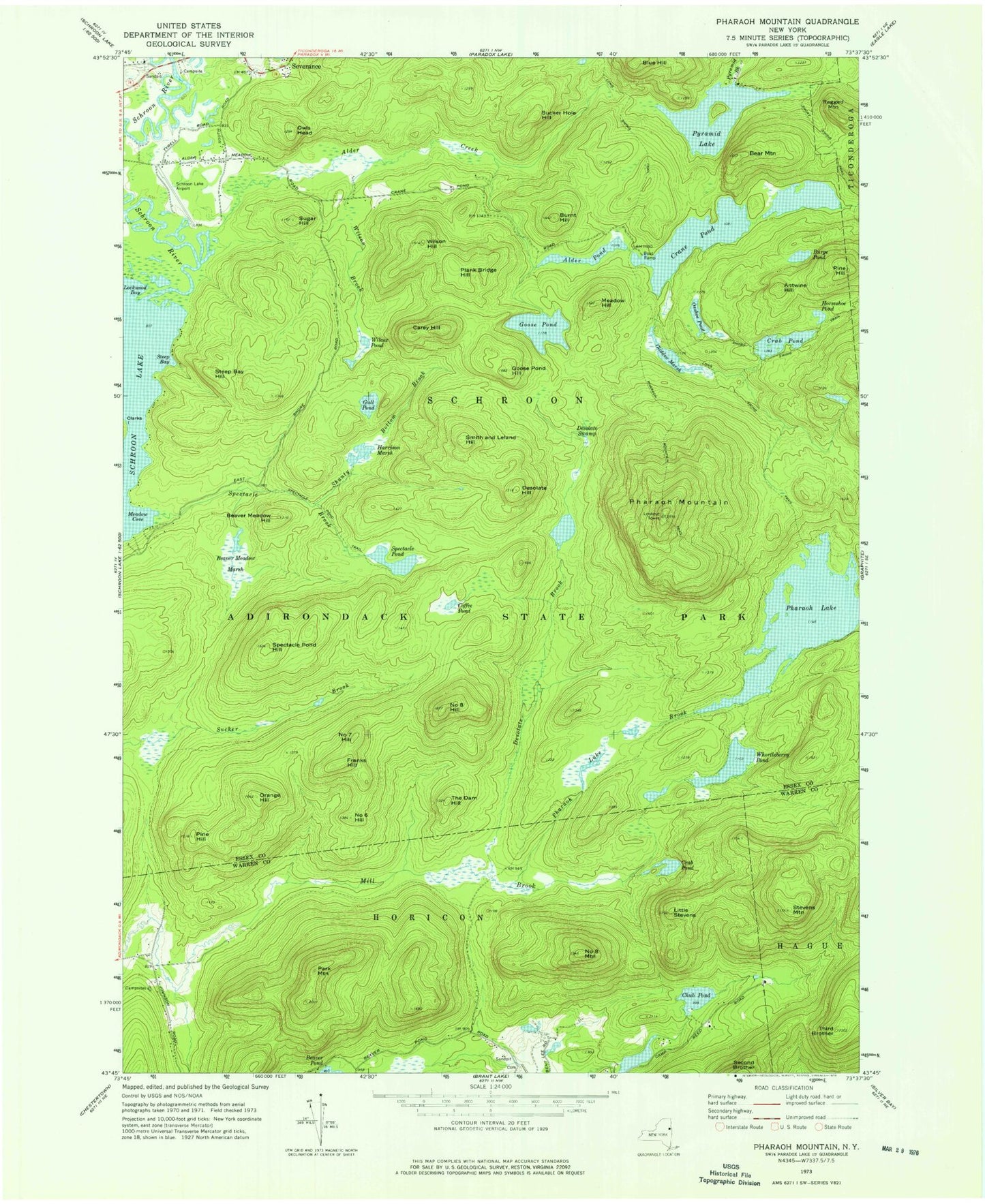
USGS Classic Pharaoh Mountain New York 7.5'x7.5' Topo Map
Couldn't load pickup availability
Historical USGS topographic quad map of Pharaoh Mountain in the state of New York. Scale: 1:24000. Print size: 24" x 27"
This quadrangle is in the following counties: Essex, Warren.
The map contains contour lines, roads, rivers, towns, lakes, and grids including latitude / longitude and UTM / MGRS. Printed on high-quality waterproof paper with UV fade-resistant inks.
Contains the following named places: Alder Creek, Alder Pond, Antwine Hill, Bear Mountain, Beaver Meadow Hill, Beaver Meadow Marsh, Burge Pond, Burnt Hill, Carey Hill, Chub Pond, Coffee Pond, Crab Pond, Crab Pond, Crane Pond, Desolate Brook, Desolate Hill, Desolate Swamp, Franks Hill, Glidden Marsh, Goose Pond, Goose Pond Hill, Gull Pond, Harrison Marsh, Horseshoe Pond, Little Stevens, Lockwood Bay, Long Swing Trail, Meadow Cove, Meadow Hill, Number Six Hill, Number Seven Hill, Number Eight Hill, Number Eight Mountain, Orange Hill, Owls Head, Oxshoe Pond, Park Mountain, Pharaoh Mountain, Pharoah Mountain Trail, Pine Hill, Pine Hill, Plank Bridge Hill, Platt Brook, Pyramid Brook, Pyramid Lake, Ragged Mountain, Shanty Bottom Brook, Smith and Leland Hill, Spectacle Pond, Spectacle Pond Hill, Spectacle Pond Trail, Steep Bay, Steep Bay Hill, Stevens Mountain, Sucker Hole Hill, Sugar Hill, The Dam Hill, Third Brother, Blue Hill, Pharoah Lake, Pharoah Lake Brook, Rock Pond Brook, Whortleberry Pond, Wilcox Pond, Wilson Brook, Wilson Hill, Schroon Lake Airport