MyTopo
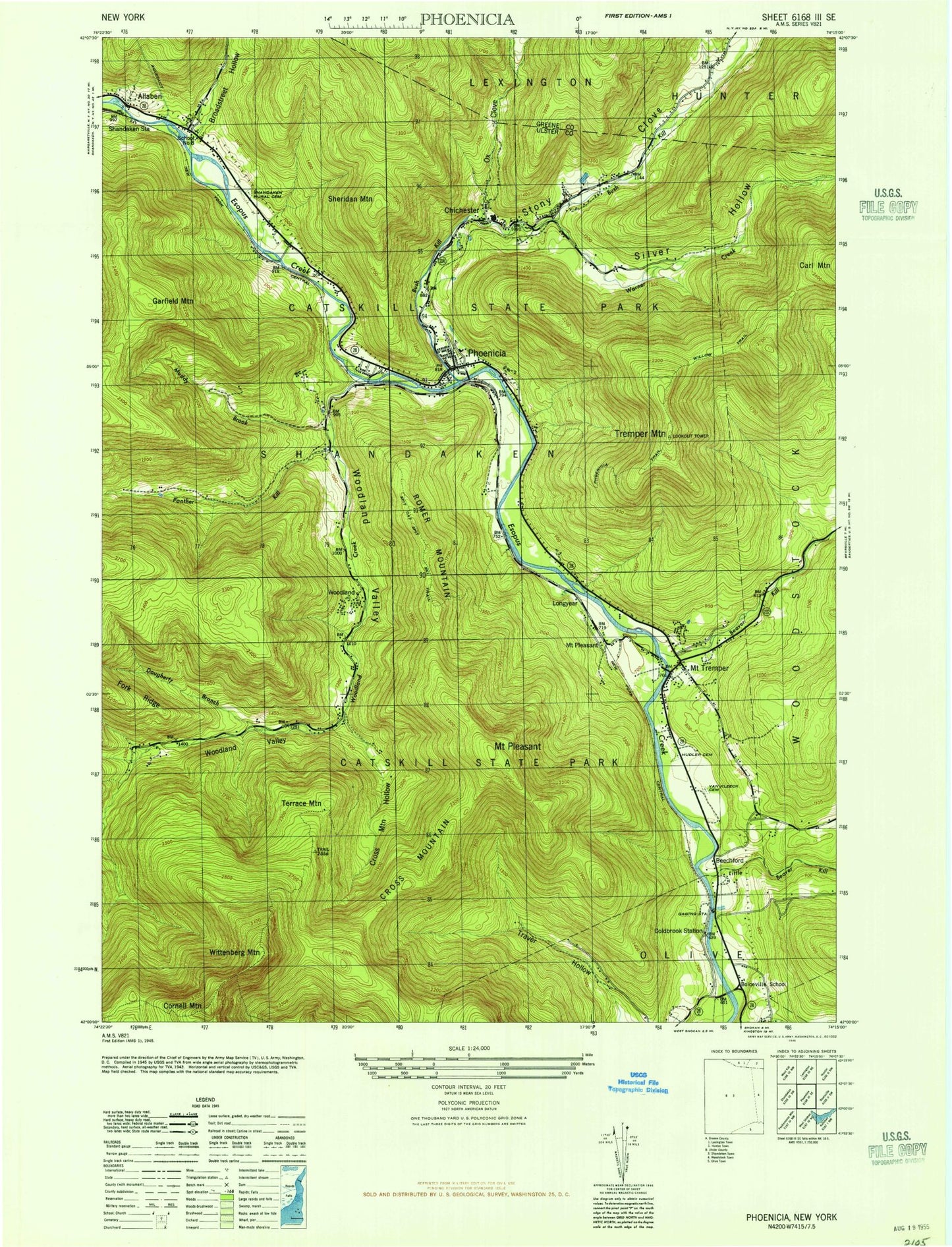
Classic USGS Phoenicia New York 7.5'x7.5' Topo Map
Couldn't load pickup availability
Historical USGS topographic quad map of Phoenicia in the state of New York. Typical map scale is 1:24,000, but may vary for certain years, if available. Print size: 24" x 27"
This quadrangle is in the following counties: Greene, Ulster.
The map contains contour lines, roads, rivers, towns, and lakes. Printed on high-quality waterproof paper with UV fade-resistant inks, and shipped rolled.
Contains the following named places: Allaben, Beaver Kill, Beechford, Reginald Bennett Elementary School, Boiceville, Broadstreet Hollow, Chichester, Cold Brook, Cross Mountain, Cross Mountain Hollow, Fork Ridge, Garfield Mountain, Hudler Cemetery, Little Beaver Kill, Longyear Cemetery, Mount Pleasant, Mount Tremper, Muddy Brook, Onteora High School, Our Lady of Good Counsel Church, Ox Clove, Panther Kill, Phoenicia, Phoenicia Trail, Mount Pleasant, Romer Mountain, Shandaken Rural Cemetery, Sheridan Mountain, Stony Clove, Stony Clove Creek, Terrace Mountain, Tremper Mountain, Mount Pleasant Cemetery, Warner Creek, Dougherty Branch, Silver Hollow, Willow Trail, Wittenberg Mountain, Woodland, Woodland Creek, Woodland Valley, Burroughs Range, Cornell Mountain, Coldbrook Station (historical), Shandaken Station (historical), Longyear (historical), Boiceville School (historical), School Number 8 (historical), Phoenicia Census Designated Place, Lanesville Cemetery, Phoenicia Elementary School, Phoenicia United Methodist Church, Phoenicia Wesleyan Church, Saint Francis de Sales Church, Chichester Post Office, Phoenicia Post Office, Catskill Corners Shopping Center, Phoenicia Library, Onteora Middle School, Onteora Hose Company, H D Lane Volunteer Fire Company, Phoenicia Volunteer Fire Company Onteora Hose Company 3, Olive Volunteer Fire Department 1 Boiceville Company 5, Phoenicia Volunteer Fire Company Whitney Hose Company 1, Mount Tremper Post Office, Boiceville Post Office, Allaben, Beaver Kill, Beechford, Reginald Bennett Elementary School, Boiceville, Broadstreet Hollow, Chichester, Cold Brook, Cross Mountain, Cross Mountain Hollow, Fork Ridge, Garfield Mountain, Hudler Cemetery, Little Beaver Kill, Longyear Cemetery, Mount Pleasant, Mount Tremper, Muddy Brook, Onteora High School, Our Lady of Good Counsel Church, Ox Clove, Panther Kill, Phoenicia, Phoenicia Trail, Mount Pleasant, Romer Mountain, Shandaken Rural Cemetery, Sheridan Mountain, Stony Clove, Stony Clove Creek, Terrace Mountain, Tremper Mountain, Mount Pleasant Cemetery, Warner Creek, Dougherty Branch, Silver Hollow, Willow Trail, Wittenberg Mountain, Woodland, Woodland Creek, Woodland Valley, Burroughs Range, Cornell Mountain, Coldbrook Station (historical), Shandaken Station (historical), Longyear (historical), Boiceville School (historical), School Number 8 (historical), Phoenicia Census Designated Place, Lanesville Cemetery, Phoenicia Elementary School, Phoenicia United Methodist Church, Phoenicia Wesleyan Church, Saint Francis de Sales Church, Chichester Post Office, Phoenicia Post Office, Catskill Corners Shopping Center, Phoenicia Library, Onteora Middle School, Onteora Hose Company, H D Lane Volunteer Fire Company, Phoenicia Volunteer Fire Company Onteora Hose Company 3, Olive Volunteer Fire Department 1 Boiceville Company 5, Phoenicia Volunteer Fire Company Whitney Hose Company 1, Mount Tremper Post Office, Boiceville Post Office