MyTopo
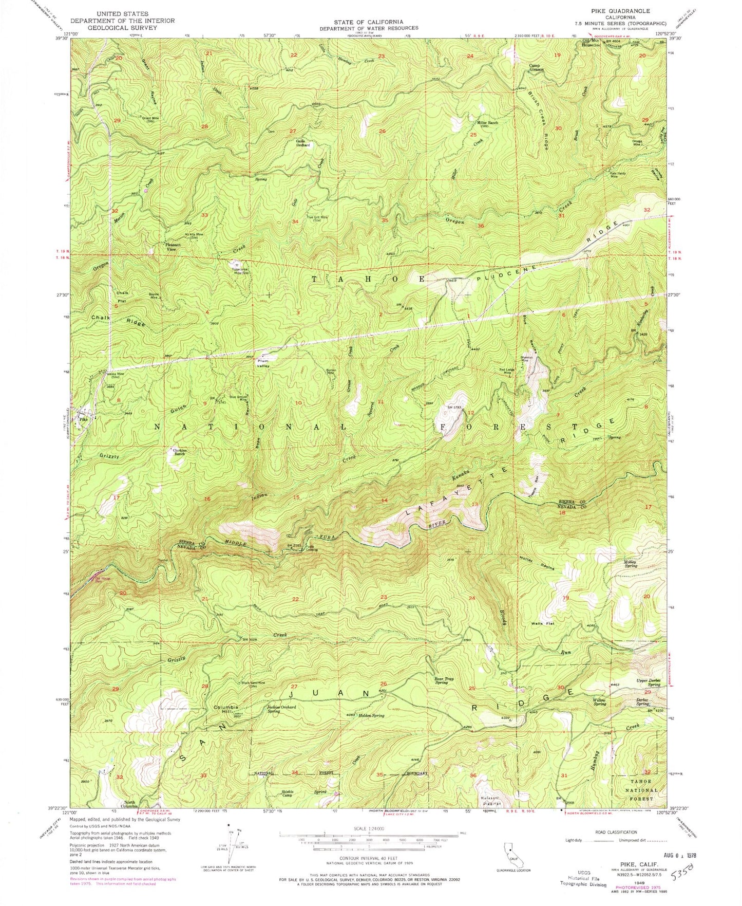
Classic USGS Pike California 7.5'x7.5' Topo Map
Couldn't load pickup availability
Historical USGS topographic quad map of Pike in the state of California. Typical map scale is 1:24,000, but may vary for certain years, if available. Print size: 24" x 27"
This quadrangle is in the following counties: Nevada, Sierra.
The map contains contour lines, roads, rivers, towns, and lakes. Printed on high-quality waterproof paper with UV fade-resistant inks, and shipped rolled.
Contains the following named places: Alaska Mine, Beame Mine, Bear Trap Spring, Black Sand Mine, Bloody Run, Blue Grouse Mine, Blue Ravine, Bope Ravine, Brush Creek, Brush Creek Ridge, Camp Gleason, Chalk Flat, Chalk Ridge, Clerkins Ranch, Columbia Hill, Derbec Spring, Gale Creek, Gales Orchard, Grouse Creek, Holden Springs, Holley Ravine, Indian Creek, Jackies Orchard Spring, Kanaka Creek, Kate Hardy Mine, Kimberley Creek, Lafayette Ridge Trail, Long Point Trail, Lucky Dog Creek, Marion Creek, Miller Creek, Miller Ranch, Mobley Spring, Mount Alta Mine, Omega Mine, Orient Mine, Our House Dam, Pleasant View, Plum Valley, Red Ledge Mine, Roman Mine, Shannon Mine, Shields Camp, Jersey Ravine, Squirrel Creek, Tippecanoe Mine, Trestle Ravine, True Grit Mine, Upper Derbec Spring, Walls Flat, Willow Spring, Pliocene Forest Service Station, Foote Crossing, Pike, Trapper Camp, Columbia Hill CDF Fire Station, Negro Tent, Lone Grave, Graveyard Hill, Backbone House (historical), Chute Hill Campground, Columbia Hill Ranger Station (historical), Cold Spring (historical), Cold Spring, Grizzly Gulch (historical), Miller Spring, Nelson Mill, Phippen Sawmill (historical), Plum Valley, Tippecanoe (historical), Footes Crossing Bridge, Jenkins Ranch (historical), Kimberlin Ravine, Watsons Quartz Mine, Pike Census Designated Place, Pike City Cemetery, Alaska Mine, Beame Mine, Bear Trap Spring, Black Sand Mine, Bloody Run, Blue Grouse Mine, Blue Ravine, Bope Ravine, Brush Creek, Brush Creek Ridge, Camp Gleason, Chalk Flat, Chalk Ridge, Clerkins Ranch, Columbia Hill, Derbec Spring, Gale Creek, Gales Orchard, Grouse Creek, Holden Springs, Holley Ravine, Indian Creek, Jackies Orchard Spring, Kanaka Creek, Kate Hardy Mine, Kimberley Creek, Lafayette Ridge Trail, Long Point Trail, Lucky Dog Creek, Marion Creek, Miller Creek, Miller Ranch, Mobley Spring, Mount Alta Mine, Omega Mine, Orient Mine, Our House Dam, Pleasant View, Plum Valley, Red Ledge Mine, Roman Mine, Shannon Mine, Shields Camp, Jersey Ravine, Squirrel Creek, Tippecanoe Mine, Trestle Ravine, True Grit Mine, Upper Derbec Spring, Walls Flat, Willow Spring, Pliocene Forest Service Station, Foote Crossing, Pike, Trapper Camp, Columbia Hill CDF Fire Station, Negro Tent, Lone Grave, Graveyard Hill, Backbone House (historical), Chute Hill Campground, Columbia Hill Ranger Station (historical), Cold Spring (historical), Cold Spring, Grizzly Gulch (historical), Miller Spring, Nelson Mill, Phippen Sawmill (historical), Plum Valley, Tippecanoe (historical), Footes Crossing Bridge, Jenkins Ranch (historical), Kimberlin Ravine, Watsons Quartz Mine, Pike Census Designated Place, Pike City Cemetery