MyTopo
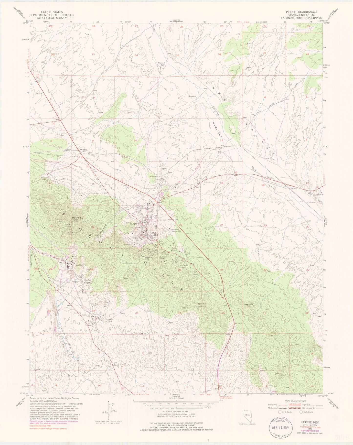
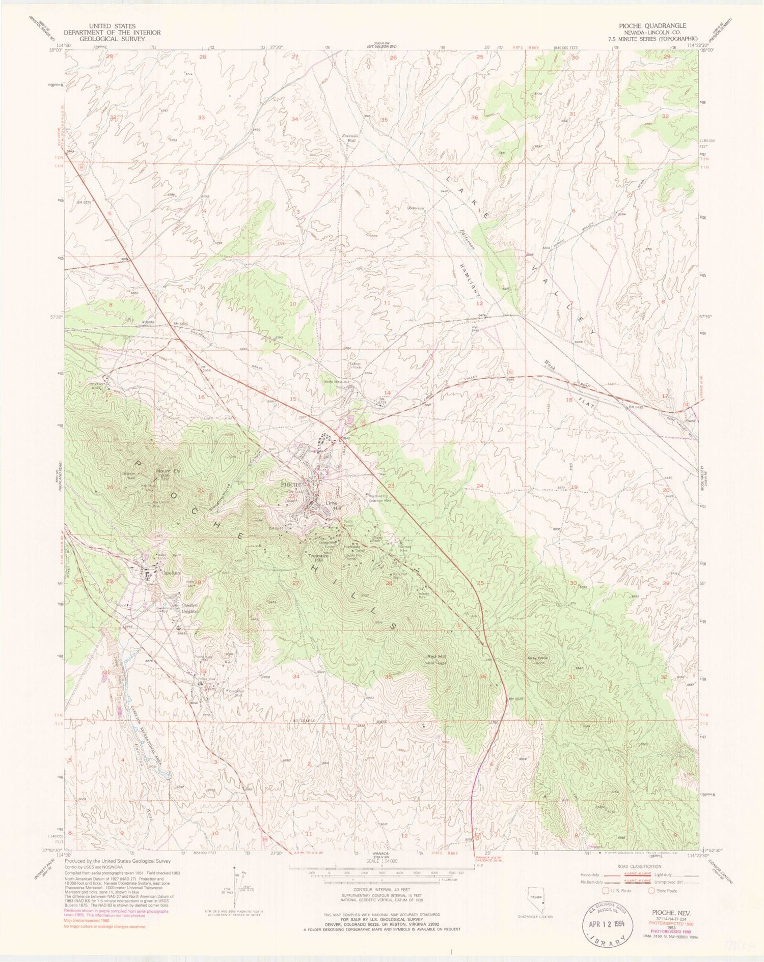
Classic USGS Pioche Nevada 7.5'x7.5' Topo Map
Couldn't load pickup availability
Historical USGS topographic quad map of Pioche in the state of Nevada. Map scale may vary for some years, but is generally around 1:24,000. Print size is approximately 24" x 27"
This quadrangle is in the following counties: Lincoln.
The map contains contour lines, roads, rivers, towns, and lakes. Printed on high-quality waterproof paper with UV fade-resistant inks, and shipped rolled.
Contains the following named places: Abe Lincoln Mine, Acme Mine, Alps Mine, Amalgamated Pioche Mine, American Flag Mine, Arkansas Mine, Atlanta, Blue Bell Mine, Boston Pioche Mine, Bowery Shaft, Bud Rudy Mine, Burke Mine, California Pioche Mine, Caselton, Caselton Heights, Caselton Mill, Caselton Pond Number 10 Dam, Caselton Pond Number 4 Dam, Caselton Pond Number 5 Dam, Caselton Pond Number 8 Dam, Caselton Pond Number 9 Dam, Caselton Recreation Area Last Pond Dam, Caselton Recreational Area, Caselton Shaft, Centennial Shaft, Chapman Mine, Chicago Nevada Mine, Chief of the Hill Mine, Chisholm Mine, Chope Mine, Churndrill Canyon, Claflin, Combined Metals Reduction Company Mill, Cottino Mine, Daily East Shaft, Doris Group Mine, Ely Valley Contact Mine, Ely Valley Mines, Excelsior Mine, Floral Springs, Four Mile House, Four Mile Ranch, Fourmile Well, Garrison Mine, Gold and Silver Prince Mine, Golden Eagle Shaft, Golden Prince Mine, Gray Cone, Half Moon Mine, Hermes Mine, Homestake Tunnel, Huhn and Hunt Mine, Independent Order of Odd Fellows Masonic Cemetery, Ingomer Mine, Ivanhoe Mine, Kentucky Mine, Lake Valley, Lightner Shaft, Lime Hill, Lincoln County Ambulance Service, Lincoln County Sheriff's Office, Lincoln Nevada Mine, Manhattan Mill, Meadow Valley Shaft Three, Meadow Valley Summit Shaft, Missouri Prince Mine, Mount Ely, Nevada Desmoins Mine, Nevada Division of Forestry Fire Station, Nevada Highway Patrol Southern Command - Pioche Substation, Nevada Utah Mine, Newark Mine, North Pole Tunnel, Number Fifteen Shaft, Number One Shaft, Number Three Shaft, Ohio Kentucky Mine, Old Lincoln County Courthouse, Old Panacca Mine, Pacific Tunnel, Page and Panacca Mine, Pioche, Pioche Boot Hill Cemetery, Pioche Census Designated Place, Pioche Champion Mine, Pioche Consolidated Mine, Pioche Demijohn Mine, Pioche Elementary School, Pioche Fire Station, Pioche Gold Crown Mine, Pioche Hills, Pioche King Mine, Pioche Mine, Pioche Mines Mill, Pioche Mining District, Pioche Mohawk Mine, Pioche Pacific Mine, Pioche Phenix Mine, Pioche Post Office, Pioche Public Cemetery, Pioche Volunteer Fire Department Station 2, Pioche Western Extension Mine, Poorman Mine, Portland Pioche Mine, Prince, Prince Extension Mine, Prince Mine, Princeton, Princeton Post Office, Raymond and Ely Mine, Raymond Ely Extension Mine, Raymond Ely West Mine, Red Hill, Rhonado Mine, Rustic Mine, Salt Lake Pioche Mine, Scott Mine, Slaughterhouse Canyon, Springtime Tunnel, Step Ridge, Sun Moon Mine, Timer Mine, Tollock Doll Mine, Treasure Hill, Treasure Hill Mine, Upper Patterson Reservoir, Virginia Louise Mine, Volcano Mine, Washington and Creole Mine, Wide Awake Shaft, Williams Hill