MyTopo
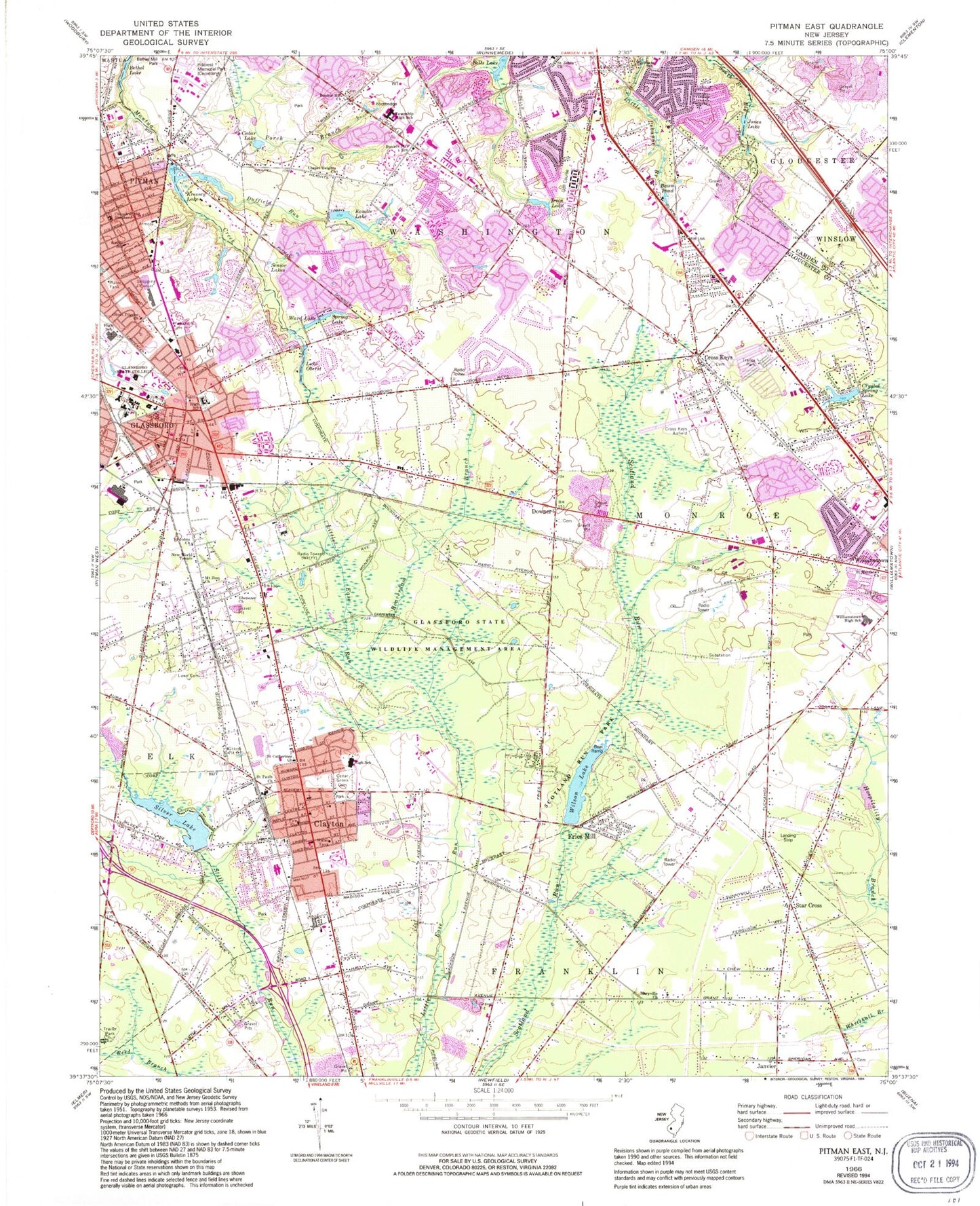
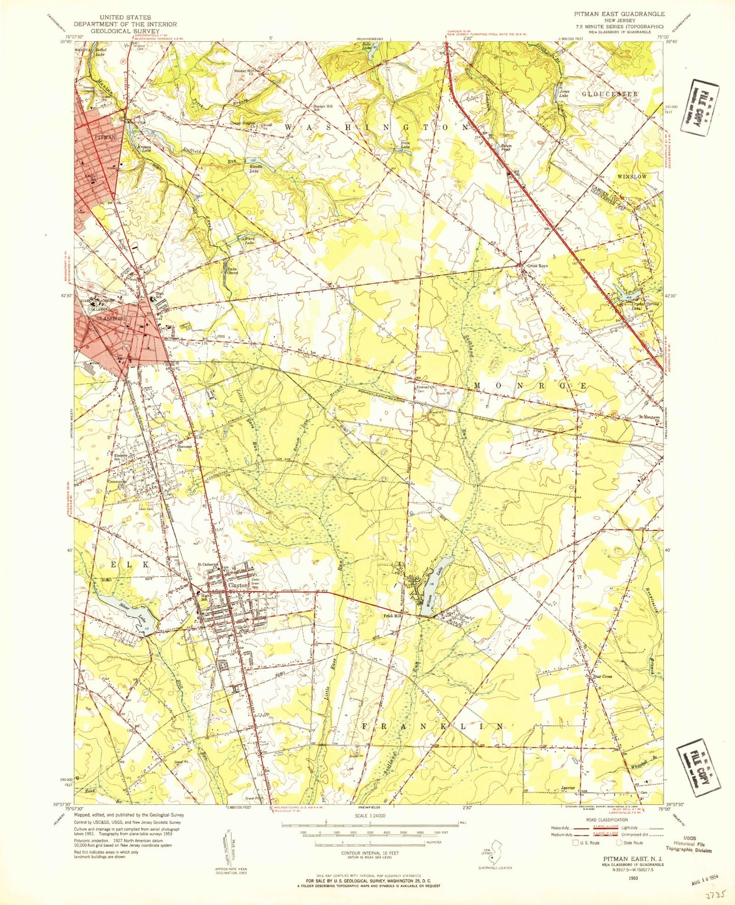
Classic USGS Pitman East New Jersey 7.5'x7.5' Topo Map
Couldn't load pickup availability
Historical USGS topographic quad map of Pitman East in the state of New Jersey. Typical map scale is 1:24,000, but may vary for certain years, if available. Print size: 24" x 27"
This quadrangle is in the following counties: Camden, Gloucester.
The map contains contour lines, roads, rivers, towns, and lakes. Printed on high-quality waterproof paper with UV fade-resistant inks, and shipped rolled.
Contains the following named places: Baum Pond, Beaverdam Branch, Bunker Hill Church, Bunker Hill School, Cedar Green Cemetery, Cedar Lake, Chapel Heights Church, Church of the Shepherd, Clayton, Cross Keys, Crystal Spring Lake, Downer, Duffield Run, Ebenezer Church, Fries Mill, Glassboro, Rowan University, Irvin Lake, Janvier, Jones Lake, Kandle Lake, Elwood Kindle Elementary School, Kressey Lake, Land Of Canaan Cemetery, Manahath Cemetery, Maryville Church, Mount Zion Church, New World Temple, Lake Oberst, Olivet Pilgrim Church, Saint Catherines Church, Saint Johns Church, Saint Johns Church, Saint Matthews Church, Saint Pauls Church, Senior Lakes, Silver Lake, Slab Bridge Branch, Spring Lake, Star Cross, Ward Lake, Whitman Elementary School, Williamstown High School, Wilson Lake, Township of Washington, Cross Keys Airport, Downer Airstrip (historical), Whitman Square, Robanna, Dilkesboro, Harding, Glassboro Fish and Wildlife Management Area, College Town Shopping Center, Silver Lake Dam, Crystal Spring Lake Dam, Fries Mill Dam, Reeder Airport (historical), WGLS-FM (Glassboro), Borough of Clayton, Borough of Glassboro, Ann A Mullen Middle School, TLC Nursery School and Learning Center, Glassboro High School, Clayton Middle School, Faith Christian Academy School, Beacon Academy Preschool and Kindergarten, Chesterbrook Academy Preschool, The Goddard School - Sicklerville, Saint Catherine of Siena Regional School, Hollydell School, Clayton High School, Bunker Hill Middle School, Orchard Valley Middle School, Williamstown Middle School, Dorothy L Bullock School, Saint Judes Regional School South Annex, Birches Elementary School, Holly Glen Elementary School, Glassboro Intermediate School, Washington Township High School, Saint Bridget Regional School, Herma S Simmons Elementary School, Archway School - Washington Township, Thomas Jefferson Elementary School, Glassboro Fire Department, Lawns Volunteer Fire Company, Gloucester County Fire Marshal's Office, Washington Township Fire District Headquarters, Clayton Volunteer Fire Company 1, Clayton Office Fire Prevention, Star Cross Volunteer Fire Company, Williamstown Fire Company Substation, Washington Township Fire Department Station 10 - 3 Hurffville Fire Company, Hurffville Fire Company - Substation, Whitman Square Fire Company - Substation, Washington Township Fire Department - Whitman Square Substation, Robert Schober Orchards, Southern Cross Airport, Maryville Treatment Center, Kennedy University Hospital - Washington Township, Muth Family Farm, Washington Township Ambulance and Rescue, Rowan University Emergency Medical Services, Gloucester County Emergency Medical Services Station 82 - 9, Gloucester County Emergency Medical Services Station 82 - 8, Washington Twp Police Dept, Clayton Police Department, Glassboro Police Department, Clayton Post Office, Turnersville Post Office, Glassboro Post Office