MyTopo
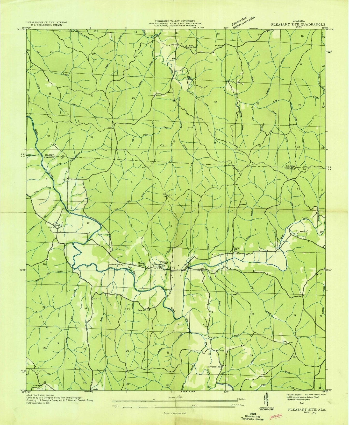
Classic USGS Pleasant Site Alabama 7.5'x7.5' Topo Map
Couldn't load pickup availability
Historical USGS topographic quad map of Pleasant Site in the state of Alabama. Typical map scale is 1:24,000, but may vary for certain years, if available. Print size: 24" x 27"
This quadrangle is in the following counties: Colbert, Franklin.
The map contains contour lines, roads, rivers, towns, and lakes. Printed on high-quality waterproof paper with UV fade-resistant inks, and shipped rolled.
Contains the following named places: Alabama Wildlife Refuge, Bat Roost Branch, Belgreen Spring Branch, Bishop Branch, Blackburn Branch, Blue Branch, Bolton Branch, Perry Bolton Cemetery, Butler Branch, Caney Branch, Chandelower Creek, Cody Branch, Crowell Branch, Daniel Branch, Double Branch, Files Branch, Finch Branch, Freedom Hills, Freedom Hills Church, Indian Hill, James Cemetery, Lick Branch, Lick Branch, Malone Hollow, Martin Branch, Mill Branch, Mingo Branch, Mitchell Branch, Parker Branch, Pleasant Site, Ramsey Mill Branch, Starky Mill Branch, Store Branch, Thorn Branch, Todd Branch, Todd Ridge, Wash Branch, White Branch, Wilson Mill Branch, New Smyrna School (historical), Smyrna Methodist Church (historical), Harmony Church, Pleasant Site Cemetery, Pogo Community Center, Lower Pleasant Site Cemetery, Patterson Strickland Cemetery, Pike Branch, Rockhouse Branch, Shoat Mill Branch, Sugar Camp Branch, Wax Spring Branch, Little Bear Creek, Pogo, Pleasant Site Post Office (historical), Freedom Hills, Pleasant Site Church, Sally Burns Cemetery, Pleasant Site Fire Protection Authority - Fire Department, Burns Cemetery, Alabama Wildlife Refuge, Bat Roost Branch, Belgreen Spring Branch, Bishop Branch, Blackburn Branch, Blue Branch, Bolton Branch, Perry Bolton Cemetery, Butler Branch, Caney Branch, Chandelower Creek, Cody Branch, Crowell Branch, Daniel Branch, Double Branch, Files Branch, Finch Branch, Freedom Hills, Freedom Hills Church, Indian Hill, James Cemetery, Lick Branch, Lick Branch, Malone Hollow, Martin Branch, Mill Branch, Mingo Branch, Mitchell Branch, Parker Branch, Pleasant Site, Ramsey Mill Branch, Starky Mill Branch, Store Branch, Thorn Branch, Todd Branch, Todd Ridge, Wash Branch, White Branch, Wilson Mill Branch, New Smyrna School (historical), Smyrna Methodist Church (historical), Harmony Church, Pleasant Site Cemetery, Pogo Community Center, Lower Pleasant Site Cemetery, Patterson Strickland Cemetery, Pike Branch, Rockhouse Branch, Shoat Mill Branch, Sugar Camp Branch, Wax Spring Branch, Little Bear Creek, Pogo, Pleasant Site Post Office (historical), Freedom Hills, Pleasant Site Church, Sally Burns Cemetery, Pleasant Site Fire Protection Authority - Fire Department, Burns Cemetery