MyTopo
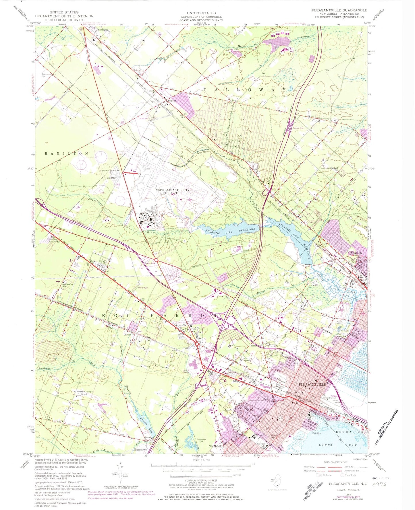
Classic USGS Pleasantville New Jersey 7.5'x7.5' Topo Map
Couldn't load pickup availability
Historical USGS topographic quad map of Pleasantville in the state of New Jersey. Map scale may vary for some years, but is generally around 1:24,000. Print size is approximately 24" x 27"
This quadrangle is in the following counties: Atlantic.
The map contains contour lines, roads, rivers, towns, and lakes. Printed on high-quality waterproof paper with UV fade-resistant inks, and shipped rolled.
Contains the following named places: Ables Run, Absalom Doughty Pond Dam, Absecon Emergency Services, Absecon Fire Safety Official, Absecon Highland School, Absecon Police Department, Absecon Post Office, Absecon Volunteer Fire Department, Absegami High School, American Medical Response Shore Operations, Arthur Rann School, Atlantic City Cemetery, Atlantic City International Airport, Atlantic City International Airport Fire Department 24 - 1, Atlantic City Medical Center, Atlantic City Medical Center - Mainland Division Heliport, Atlantic City Reservoir, Atlantic City Speedway, Atlantic County Helistop, AtlantiCare Regional Medical Center, Bacharach Institute for Rehabilitation, Bargaintown Volunteer Fire Company 2 Station 1, Bayside School, Bayview Volunteer Fire Company Station 26 - 4A, Beth Kehillah Cemetery, Birch Grove Park, Blackmans Branch, Cardiff, Cardiff Volunteer Fire Company 1, Cardiff Volunteer Fire Company 1 Station 2, Cedar Branch, City of Pleasantville, Clayton J Davenport Primary School, Cologne Census Designated Place, Conovers Creek, Davenport School, Dolphin Station, Doughty Pond Upper Dam, Egg Harbor Township Ambulance Squad, English Creek Academy PreSchool, Farmington School, Farmington Volunteer Fire Company 4, Fernwood Avenue Middle School, Galloway Township Ambulance Squad Station 1 Headquarters, Galloway Township Middle School, Germania Heliport, Grace Church, Graves Temple, Green Acres Park, Greenwood Cemetery, Heritage Park, Highland Church, Holy Spirit High School, Ingersolls Branch, James Locuson School, Jersey Shore Baptist Academy, Laurel Memorial Cemetery, Leeds Avenue School, Little Meadow Run, McGinnis Landing Strip, McKee City School, McKee City Station, Mount Calvary Cemetery, Mount Calvary Station, Mount Olive Church, Mount Pleasant, Mount Pleasant Church, Municipal Yacht Basin, Mutual Aid Emergency Services, Naval Air Station Atlantic City, New Jersey Air National Guard Fire Department, New Jersey State Police Troop A Atlantic City International Airport, Nordheim Flying K Airpark, North Branch Absecon Creek, North Main Street Elementary School, Northfield Fire Department Station 1, Northfield Post Office, Northfield Rescue Squad, Oasis United Methodist Church, Patcong Lake, Pine View Church, Pinehurst, PleasanTech Academy 2 Charter School, PleasanTech Academy Charter School, Pleasantville, Pleasantville Fire Department and Emergency Medical Services, Pleasantville High School, Pleasantville Middle School, Pleasantville Police Department, Pleasantville Post Office, Pomona, Pomona Census Designated Place, Pomona Elementary School, Pomona Post Office, Pomona Volunteer Fire Company, Reeds Road Elementary School, Rodef Sholom Cemetery, Roland E Rogers Elementary School, Saint Marks Church, Saint Paul Church, Saint Peter School, Seasor Park, SENIOR Transportation, Shore Mall, South Branch Absecon Creek, South Main Street Elementary School, Stockton State College, Stockton University Census Designated Place, Township of Egg Harbor, Trocki Hebrew Academy School of Alantic County, True Vine Church, Union Church, Washington Avenue Elementary School, West Atlantic City Volunteer Fire Company 5, WLFR-FM (Pomona), WMGM-FM (Atlantic City), WOND Radio Tower (Conway), WOND-AM (Pleasantville), YALE School East, ZIP Codes: 08232, 08234, 08240