MyTopo
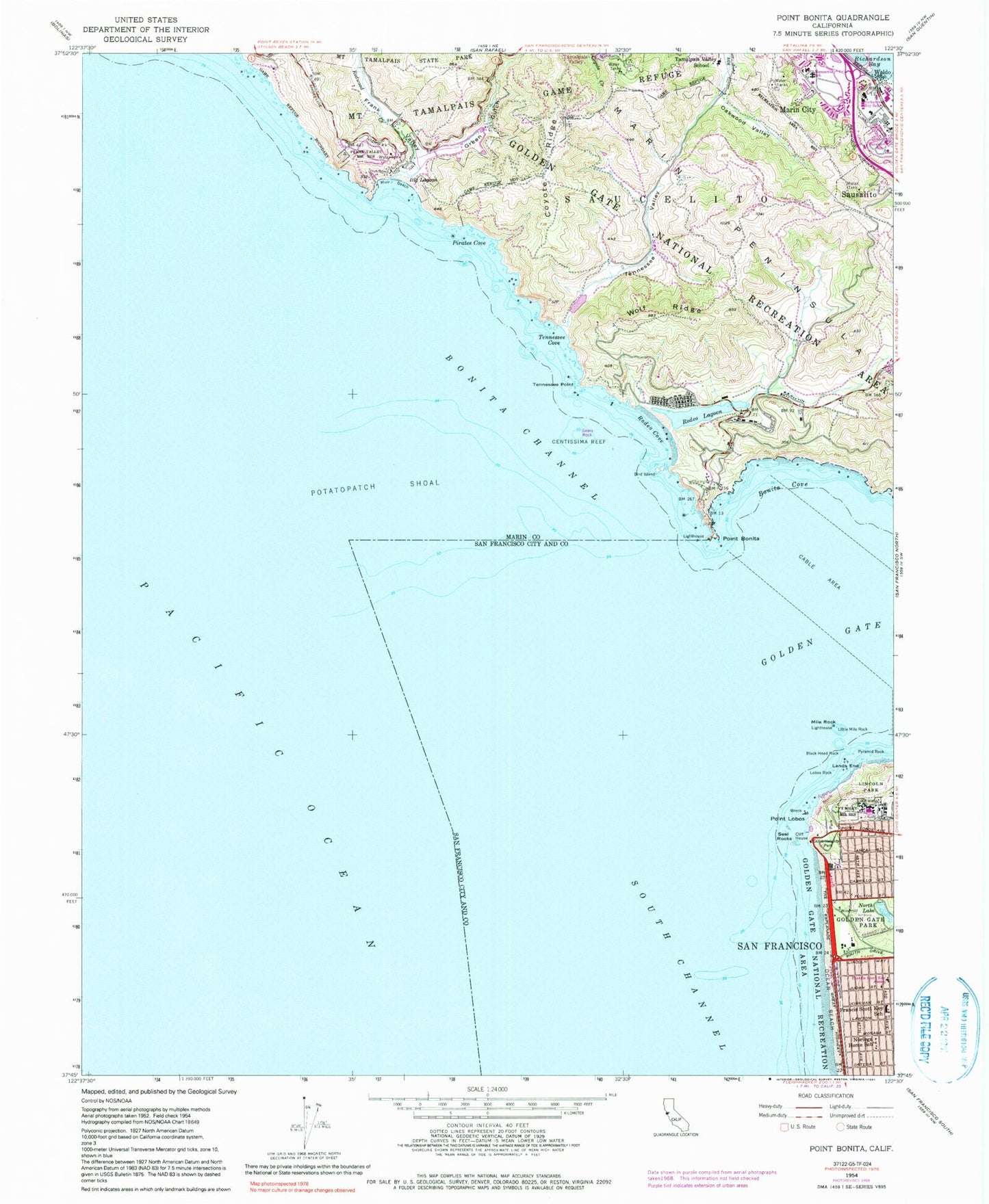
Classic USGS Point Bonita California 7.5'x7.5' Topo Map
Couldn't load pickup availability
Historical USGS topographic quad map of Point Bonita in the state of California. Typical map scale is 1:24,000, but may vary for certain years, if available. Print size: 24" x 27"
This quadrangle is in the following counties: Marin, San Francisco.
The map contains contour lines, roads, rivers, towns, and lakes. Printed on high-quality waterproof paper with UV fade-resistant inks, and shipped rolled.
Contains the following named places: Bayside Elementary School, Big Lagoon, Bird Island, Black Head Rock, Bonita Channel, Bonita Cove, Centissima Reef, Cliff House, Coyote Ridge, Fort Miley Military Reservation (historical), Francis Scott Key Annex, Francis Scott Key Elementary School, Frank Valley, Green Gulch, Lands End, Lincoln Park, Little Mile Rock, Manzanita School, Marin Headlands State Park, Marin Peninsula, Mile Rock, Muir Beach, Noriega Home School, North Lake, Ocean Beach, Pirates Cove, Point Lobos, Redwood Creek, North Bay Elementary School, Rodeo Lagoon, Saucelito, Sears Rock, Oakwood Valley, Rodeo Cove, Seal Rocks, South Channel (historical), Tamalpais Valley Elementary School, Tennessee Cove, Tennessee Point, Wolf Ridge, Palace of the Legion of Honor, Waldo, Four Fathom Bank, Point Bonita, Potatopatch Shoal, Pyramid Rock, Sutro Heights Park, Tennessee Valley, Golden Gate National Recreation Area, Golden Gate Park Golf Course, Mile Rock Lighthouse, Murphy Windmill, North Windmill, Playland at the Beach, Sutro Baths (historical), USS San Francisco Memorial, Assyrian Church of the East, Bercut Equitation Field, Queen Wilhelmina Tulip Garden, Richmond-Sunset Sewage Treatment Plant, Saint Francis Methodist Church, Saint Francis Methodist Episcopal Church (historical), Saint Pauls Presbyterian Church, Saint Thomas the Apostle Roman Catholic Church, San Francisco Ice Skating Rink, Seventh Day Adventist Chinese Church of San Francisco, Sunset Branch Lutheran Church of the Holy Spirit, Sunset Chinese Baptist Church, Rivendell School, Musee Mecanique, Seal Rocks Beach, Lobos Rock, Marin City, Tennessee Valley Dam, Rodeo Beach, Point Bonita Lighthouse, Marin Headlands, Battery Alexander Campground, Battery Mendell (historical), Battery Mendell Campground, Battery Rathbone-McIndoe (historical), Battery Wallace (historical), Bicentennial Campground, Bird Island Overlook, California Marine Mammal Research Center, Fort Barry Chapel (historical), Fort Barry Military Reservation (historical), Fort Cronkhite (historical), Gerbode Valley, Green Gulch Farm, Green Gulch Trail, Hawk Campground, Hawk Trail, Haypress Campground, Haypress Pond, Headlands Institute, Hill 88, Lower Fishermans Trail, Marin City Branch Marin County Free Library, Marin Headlands Visitor Center, Martin Luther King Junior Park, Miwok Trail, Muir Beach Overlook, Owl Trail, Pacific Energy and Resource Center, Rhubarb Trail, Slide Ranch, Upper Fishermans Trail, Waldo Point Harbor, Wolf Ridge Trail, Clydes Ridge, Muir Beach, Nike Site SF-87L (historical), Nike Site SF-88C (historical), Nike Site SF-88L (historical), San Francisco Fire Department Station 34, Muir Beach Census Designated Place, Childrens Cultural Center of Marin, Bayside Martin Luther King Jr Academy, Willow Creek Academy, San Francisco Fire Department Station 23, Golden Gate National Recreation Area Fire Department, Marin County Fire Department Marin City, Muir Beach Volunteer Fire Department, Marin City Census Designated Place, San Francisco Veterans Affairs Medical Center, Bird Island Arch, Point Bonita Arch, Marin County Sheriff's Office Southern Substation