


MyTopo
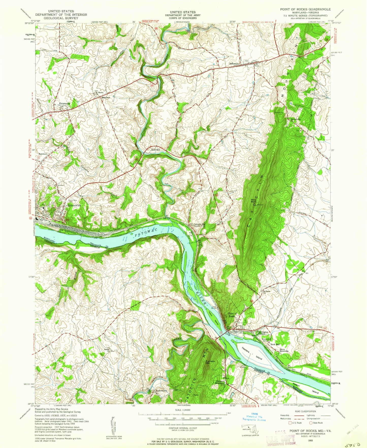
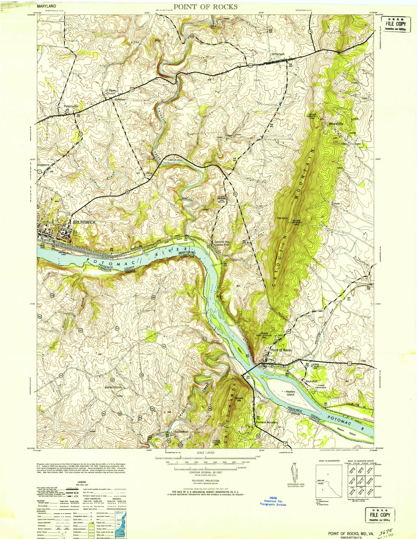
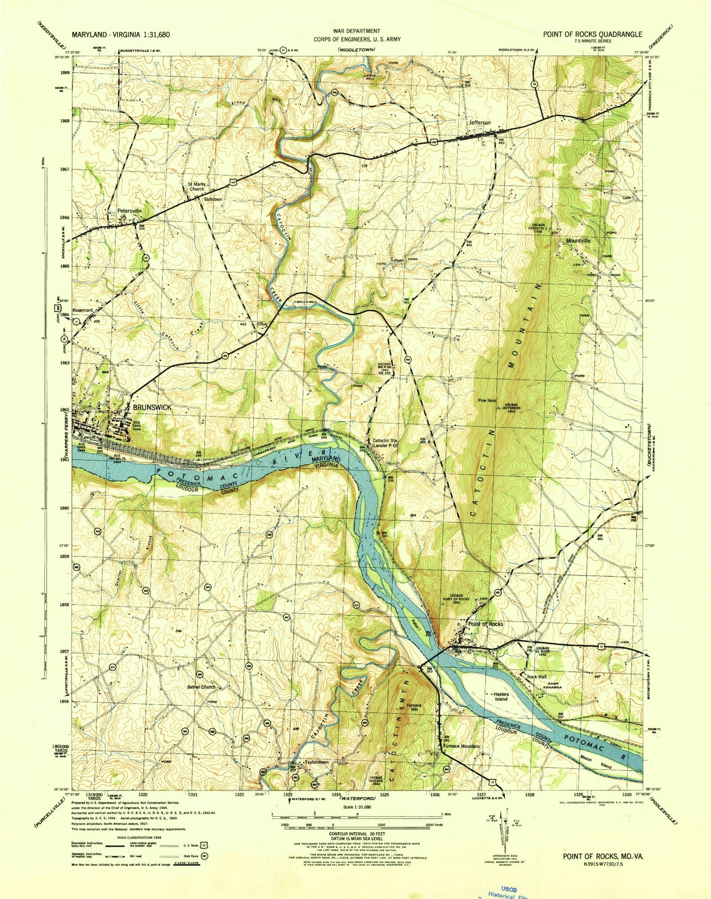
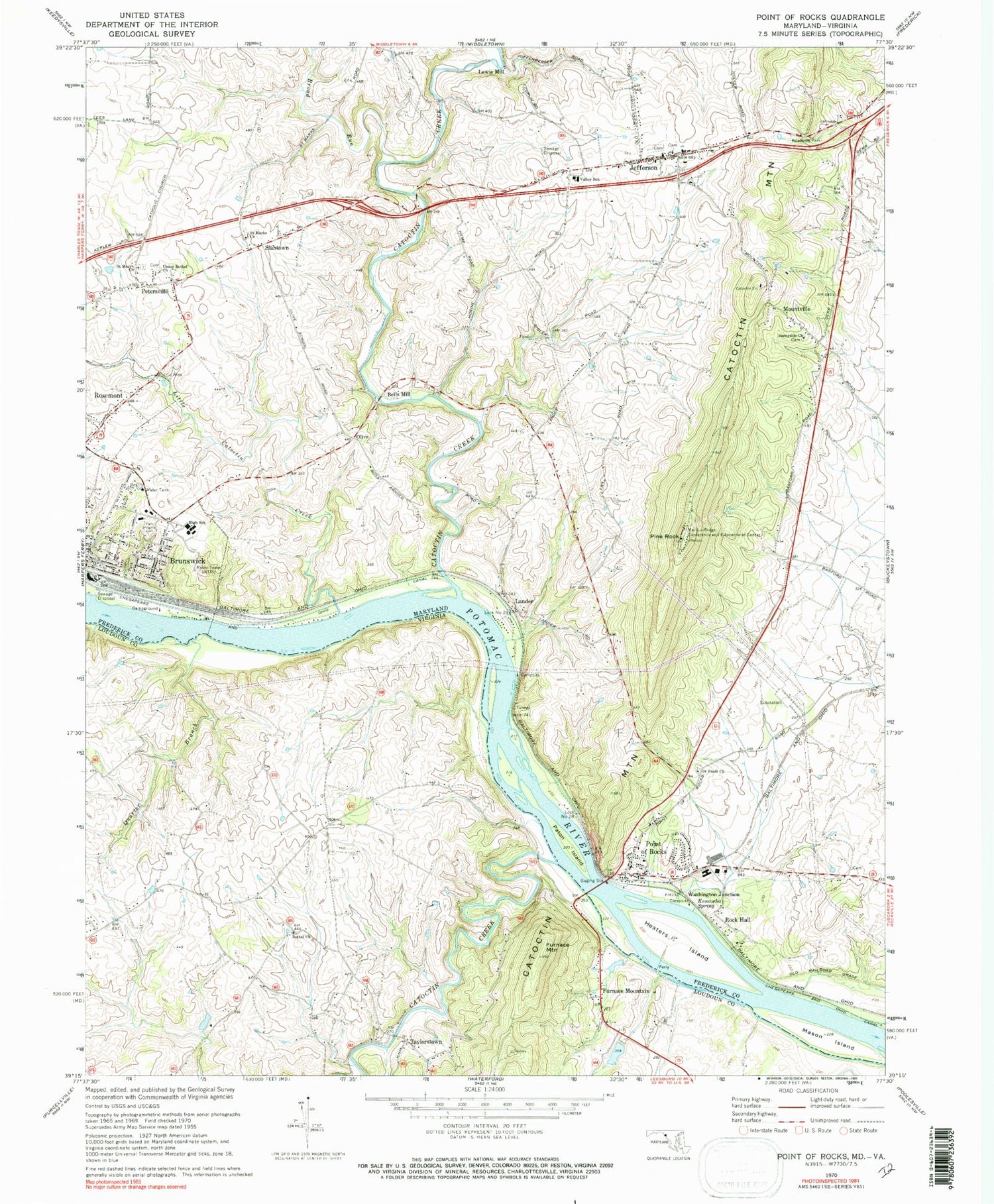
Classic USGS Point of Rocks Maryland 7.5'x7.5' Topo Map
Couldn't load pickup availability
Historical USGS topographic quad map of Point of Rocks in the states of Maryland, Virginia. Typical map scale is 1:24,000, but may vary for certain years, if available. Print size: 24" x 27"
This quadrangle is in the following counties: Frederick, Loudoun.
The map contains contour lines, roads, rivers, towns, and lakes. Printed on high-quality waterproof paper with UV fade-resistant inks, and shipped rolled.
Contains the following named places: Broad Run, Catoctin Creek, Heaters Island, Jefferson, Kanawha Spring, Little Catoctin Creek, Mar-Lu-Ridge Conference and Educational Center, Mason Island, Park Heights Cemetery, Paton Island, Petersville, Pine Rock, Saint Marks Church, Saint Marys Church, Saint Pauls Church, Sunnyside Church, Union Bethel Church, Valley Elementary School, Lander, Olive, Washington Junction, Bells Mill, Lewis Mill, Mountville, Point of Rocks, Rock Hall, Rosemont, Slabtown, Lock Number 28, WTRI-AM (Brunswick), Bald Eagle Island Campground, Boss Arnold Village, Bradbury Heights, Briercrest Heights, Brunswick Branch Frederick County Library, Brunswick City Park, Brunswick High School, Brunswick Historic District, Brunswick Medical Center, Brunswick Middle School, Brunswick Riverside Park, Burgee, Catoctin Creek Aqueduct, Catoctin Point, Copperfield, Eastwick, Fairview, Faith Baptist Church, Gapview Farm, Grace Episcopal Church, Jefferson United Methodist Church Cemetery, Jefferson Court, Jefferson Oaks, Jefferson Post Office, Jefferson Union Cemetery, Jefferson United Church of Christ, Jefferson United Methodist Church, Jefferson View, Lander Branch, Lewis Mill Branch, Lock Number 29, Merry Midnight, Middlebrook, New York Hill United Methodist Church, Olive School (historical), Potomac Overlook, Roundtree, Saint Mark's Apostolic Church Cemetery, Saint Mary's Cemetery, Saint Paul Lutheran Church, Springview, Stockman Estates, Sunrise, The Brunswick Shopping Center, Virts, Adamstown Village, Calico Rocks, Calico Rocks Campground, Camp Kanawha, Canavest (historical), Concord, Heaters Island Wildlife Management Area, Indian Town Landing, Jefferson Heights, Mar-Lu-Ridge Vista, Point of Rocks Assembly of God Church, Point of Rocks Community Park, Point of Rocks Estates, Point of Rocks Industrial Park, Point of Rocks Post Office, Point of Rocks Railroad Station, Potomac Gateway, Potomac Village, Profit Acres, Saint Paul's Episcopal Church Cemetery, Standford Industrial Park, Sunny Side Industrial Park, Washington Run, Wilber Woods, District 12 Petersville, District 14 Jefferson, District 25 Brunswick, Brunswick Branch Library, Jefferson Volunteer Fire and Rescue Station 20, Point of Rocks Fire Station 28, The Jefferson School, Village of Rosemont, Jefferson Census Designated Place, Point of Rocks Census Designated Place, Mid View Farm, Rocky Point Farm, Bethel Lutheran Church, Catoctin Creek, Furnace Mountain, Quarter Branch, Gore Dam, Gore Pond, Furnace Mountain, Taylorstown, Furnace Mountain Presbyterian Cemetery, Furnace Mountain Presbyterian Church, Lindsey Corner, Slaters Crossroads, Taylorstown Historic District, EcoVillage of Loudoun County, Proximity Dam, Broad Run, Catoctin Creek, Heaters Island, Jefferson, Kanawha Spring, Little Catoctin Creek, Mar-Lu-Ridge Conference and Educational Center, Mason Island, Park Heights Cemetery, Paton Island, Petersville, Pine Rock, Saint Marks Church, Saint Marys Church, Saint Pauls Church, Sunnyside Church, Union Bethel Church, Valley Elementary School, Lander, Olive, Washington Junction, Bells Mill, Lewis Mill, Mountville, Point of Rocks, Rock Hall, Rosemont, Slabtown, Lock Number 28, WTRI-AM (Brunswick), Bald Eagle Island Campground, Boss Arnold Village, Bradbury Heights, Briercrest Heights, Brunswick Branch Frederick County Library, Brunswick City Park, Brunswick High School, Brunswick Historic District, Brunswick Medical Center, Brunswick Middle School, Brunswick Riverside Park, Burgee, Catoctin Creek Aqueduct, Catoctin Point, Copperfield, Eastwick, Fairview, Faith Baptist Church, Gapview Farm, Grace Episcopal Church, Jefferson United Methodist Church Cemetery, Jefferson Court, Jefferson Oaks, Jefferson Post Office, Jefferson Union Cemetery, Jefferson United Church of Christ, Jefferson United Methodist Church, Jefferson View, Lander Branch, Lewis Mill Branch, Lock Number 29, Merry Midnight, Middlebrook, New York Hill United Methodist Church, Olive School (historical), Potomac Overlook, Roundtree, Saint Mark's Apostolic Church Cemetery, Saint Mary's Cemetery, Saint Paul Lutheran Church, Springview, Stockman Estates, Sunrise, The Brunswick Shopping Center, Virts, Adamstown Village, Calico Rocks, Calico Rocks Campground, Camp Kanawha, Canavest (historical), Concord, Heaters Island Wildlife Management Area, Indian Town Landing, Jefferson Heights, Mar-Lu-Ridge Vista, Point of Rocks Assembly of God Church, Point of Rocks Community Park, Point of Rocks Estates, Point of Rocks Industrial Park, Point of Rocks Post Office, Point of Rocks Railroad Station, Potomac Gateway, Potomac Village, Profit Acres, Saint Paul's Episcopal Church Cemetery, Standford Industrial Park, Sunny Side Industrial Park, Washington Run, Wilber Woods, District 12 Petersville, District 14 Jefferson, District 25 Brunswick, Brunswick Branch Library, Jefferson Volunteer Fire and Rescue Station 20, Point of Rocks Fire Station 28, The Jefferson School, Village of Rosemont, Jefferson Census Designated Place, Point of Rocks Census Designated Place, Mid View Farm