MyTopo
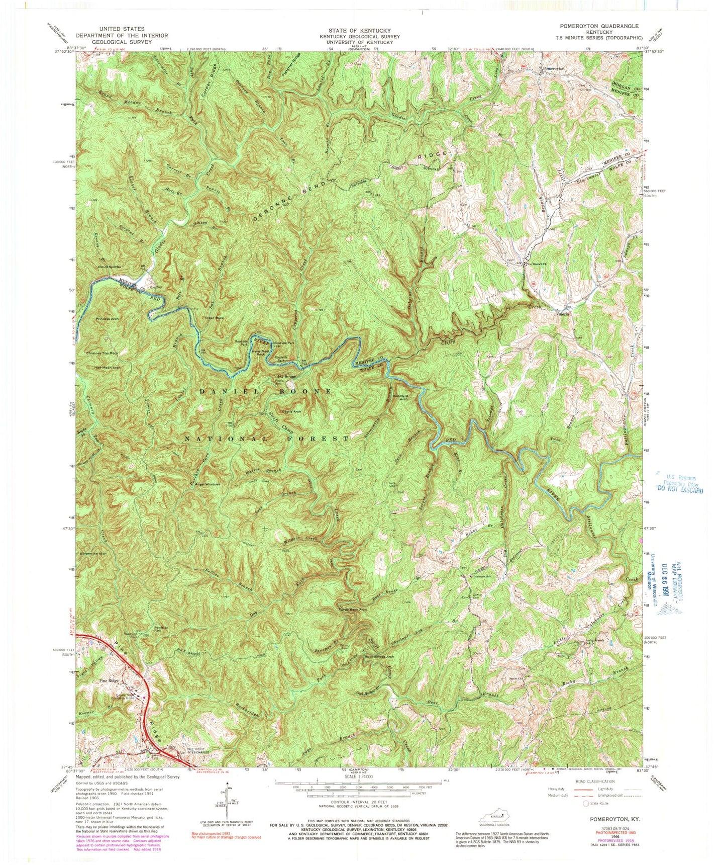
USGS Classic Pomeroyton Kentucky 7.5'x7.5' Topo Map
Couldn't load pickup availability
Historical USGS topographic quad map of Pomeroyton in the state of Kentucky. Scale: 1:24000. Print size: 24" x 27"
This quadrangle is in the following counties: Menifee, Morgan, Wolfe.
The map contains contour lines, roads, rivers, towns, lakes, and grids including latitude / longitude and UTM / MGRS. Printed on high-quality waterproof paper with UV fade-resistant inks.
Contains the following named places: Silvermine Arch, Angel Windows, Banks Branch, Bear Branch, Bearpen Branch, Bearpen Branch, Bell Branch, Big Calaboose Creek, Browns Branch, Calaboose School, Cane Branch, Castle Arch, Center Cemetery, Chestnut Log Branch, Chimney Top Rock, Clifty Creek, Cloud Splitter, Copperas Creek, Dessie Scott Childrens Home, Dog Fork, Dry Fork, Fallingwater Creek, Garrett Branch, Gibson Branch, Gladie Creek, Greasy Branch, Hale Branch, Half Moon Arch, Hens Nest Rock, King Branch, Klaber Branch, Laurel Branch, Laurel Fork, Little Calaboose Creek, Long Branch, Lost Branch, Osborne Bend Ridge, Osborne Branch, Owl Hollow Branch, Page Branch, Parched Corn Creek, Peck Branch, Peniel Church, Pine Branch, Pine Branch Baptist Church, Pine Ridge, Pomeroyton, Powell Branch, Princess Arch, Red-byrd Arch, Reffits Branch, Right Fork Chimney Top Creek, Rock Bridge Arch, Rock Bridge Trail, Rockbridge Fork, Rocky Branch School, Rose Drake Branch, Round Meadow Branch, Sal Branch, Salt Fork, Sargent Branch, Sarges Branch, Silvermine Branch, Silvermine Branch, Sky Bridge, Solomon Branch, Sons Branch, Stillwater Creek, Swift Camp Creek, Swiftcamp Creek Trail, Tower Rock, Turtle Back Arch, Twin Branch, Valeria, Whites Branch, Wildcat Creek, Wildcat Trail, Sky Bridge Recreation Site, Rock Bridge Picnic Area, Clifty Wilderness, Calaboose Post Office (historical), Calaboose Ridge, Campbell Ridge, Clifty School (historical), Green Garret Railroad Siding (historical), Hardeman Post Office (historical), Pine Ridge Post Office (historical), Pine Ridge Railroad Station (historical), Pine Ridge Visitor Center, Rock Bridge Falls, Timmons Arch, Whistling Arch, Glendive Post Office (historical), Alvan Drew School (historical), Half Moon Rock, Hells Kitchen, Valeria Post Office (historical), Blackwater (historical), Catron Cemetery, Pomeroyton Cemetery, Pomeroyton Post Office (historical), Pomeroyton Union Church, Stoll (historical), Sulpher School (historical), Adena Arch, Gladie Creek Gorge, Middle Fork, Moonshiner Arch, Indian Stairway, Red Wild and Scenic River