MyTopo
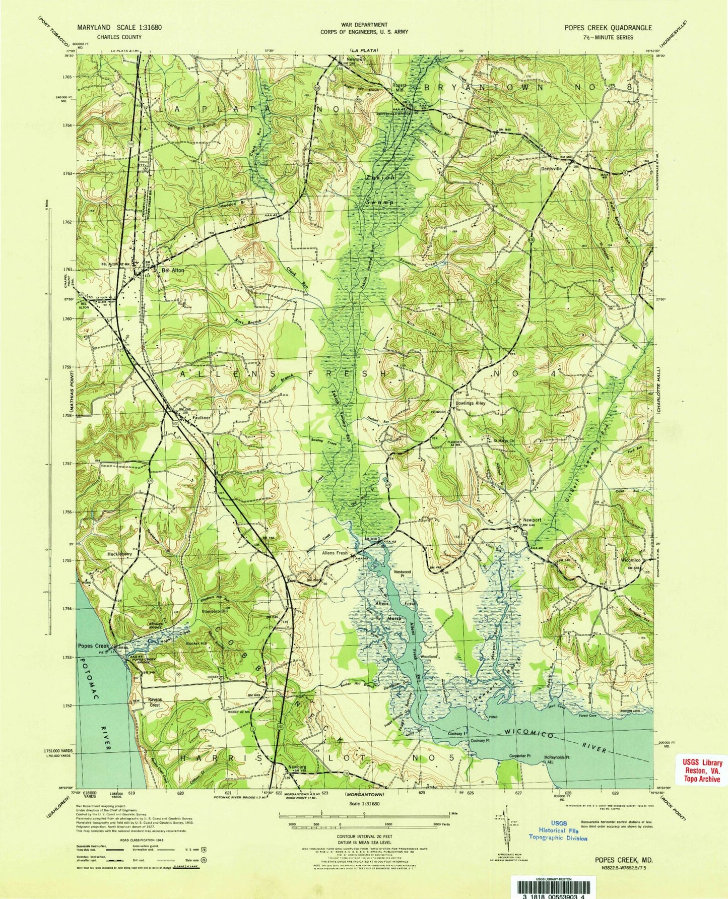
Classic USGS Popes Creek Maryland 7.5'x7.5' Topo Map
Couldn't load pickup availability
Historical USGS topographic quad map of Popes Creek in the state of Maryland. Typical map scale is 1:24,000, but may vary for certain years, if available. Print size: 24" x 27"
This quadrangle is in the following counties: Charles.
The map contains contour lines, roads, rivers, towns, and lakes. Printed on high-quality waterproof paper with UV fade-resistant inks, and shipped rolled.
Contains the following named places: Allens Fresh Run, Bowling Creek, Bowling Gut, Bowlings Alley, Bowman Creek, Bunker Hill Branch, Carpenter Point, Clark Run, Colby Run, Cooksey Island, Cooksey Point, Cooksey Run, Cramer Gut, Dentsville, Dentsville Bridge, Drinks Run, Ellenboro Hill, Ellenboro Hill Run, Faulkner, Foggy Bottoms, Foggy Bottoms Gut, Ford Run, Forest Cove, Fresh Marsh, Gilbert Swamp Run, Glasva Branch, Hells Bottom Run, Herbert Run, Hickory Gut, Hodister Run, Huckleberry Branch, Ivory Run, James Run, Lancaster Run, Lloyd Drain, Maddox Branch, McReynolds Point, Mud Cove, Mud Creek, Murphy Run, Newport Branch, Newport Marsh, Newport Marsh Run, Newport Run, Oden Run, Old Mill Branch, Peach Run, Popes Creek, Popes Creek, Popes Creek Bridge, Posey Creek, Rice Creek, Rogers Mill Branch, Ross Branch, Saint Clair Gut, Saint Marys Church, Saint Stephen Run, Scar Branch, Spring Hill Branch, Steinhauser Gut, Stoner Creek, Stones Bridge, Tears Gut, Westwood Point, Wicomico, Willmer Creek, Woodland Point, Newburg, Newport, Bel Alton, Allens Fresh, Budds Landing, Bunker Hill, Huckleberry, Ravens Crest, Rogers Mill, Zekiah Swamp Run, Amys Acres, Bel Alton Volunteer Fire Department and Emergency Medical Services, Bel Alton Estates, Bel Alton Facility, Bel Alton Post Office, Birkwood Estates, Chapel Point Woods, Cooksey Knolls, Deer Park, Faulkner Post Office, Gilbert Acres, Glasva Elementary School, Hard Corner, Huntley Estates, Husick Estates, Knollcrest, Lothair Station, Newburg Post Office, Preference Estates, Rolling Hills, Saint Marys Catholic Church Cemetery, Spring Hill (historical), Thomas Manor, Wicomico Mill (historical), Wicomico Ridge, Zekiah Swamp Natural Environment Area, District 4 Allens Fresh, Newburg Volunteer Rescue Squad and Fire Department, Dentsville Emergency Medical Services, Denstville Emergency Management Services, Woodside School, Sunny Meadow School