MyTopo
Classic USGS Port Jefferson New York 7.5'x7.5' Topo Map
Couldn't load pickup availability
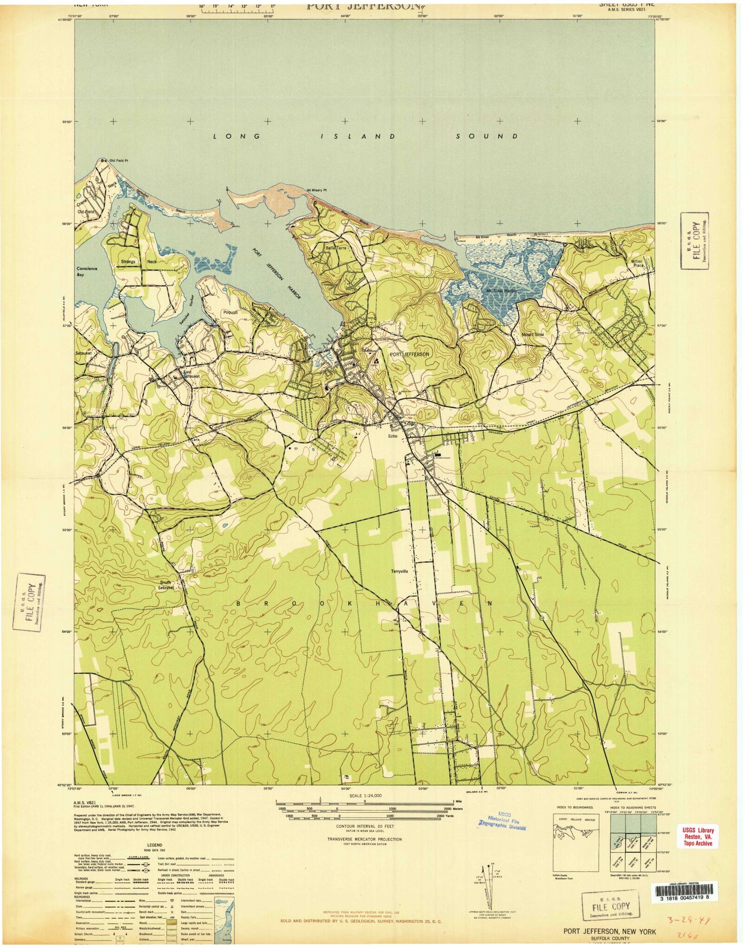
Historical USGS topographic quad map of Port Jefferson in the state of New York. Map scale may vary for some years, but is generally around 1:24,000. Print size is approximately 24" x 27"
This quadrangle is in the following counties: Suffolk.
The map contains contour lines, roads, rivers, towns, and lakes. Printed on high-quality waterproof paper with UV fade-resistant inks, and shipped rolled.
Contains the following named places: Agudat Achim Cemetery, Arrowhead Elementary School, Assembly of God Church, Atria South Setauket, Belle Terre, Belle Terre Village Hall, Bethel African - American Cemetery, Bethel African Methodist Episcopal Church, Bridgeport Ferry, Calvary Baptist Church, Camp Francoise Barstow, Caroline Church of Brookhaven, Caroline Episcopal Churchyard and Cemetery, Cedar Beach, Cedar Hill Cemetery, Centereach Bible Church, Christ Community Church, Christ Episcopal Church, Christ United Methodist Church, Comsewogue High School, Comsewogue Public Library, Conscience Bay, Coram Census Designated Place, Coram Fire Department Station 2, Crystal Brook, Crystal Brook Hollow, Earl L Vandermeulen High School, East Setauket, East Setauket Census Designated Place, East Setauket Post Office, Emma S Clark Memorial Library, First Baptist Church of Port Jefferson, First Presbyterian Church, First United Methodist Church, Full Gospel Christian Center, Greek Orthodox Church of the Assumption, Hatch Rock, Hawkins Family Graveyard, Hawkins Path Elementary School, Health Sciences Center University Hospital Heliport, Heatherwood Golf Club, Infant Jesus Roman Catholic Church, Jayne Sherwood House, Jefferson School, John F Kennedy Middle School, John T Mather Memorial Hospital, Laurel Hill Cemetery, Little Bay, Long Island State Veterans Home, Low Tide Rock, Maryhaven Center of Hope, Mather Heliport, McAllister County Park, Messiah Lutheran Church, Methodist Cemetery, Miller Place Beach, Miller Place Post Office, Millers Rock, Monastery of the Holy Cross, Monastery of the Little Portion, Moneyhollow Rock, Mount Misery, Mount Misery Point, Mount Misery Shoal, Mount Sinai, Mount Sinai Census Designated Place, Mount Sinai Congregational Church, Mount Sinai Fire Department Sub Station, Mount Sinai Fire Station, Mount Sinai Harbor, Mount Sinai Post Office, Mount Sinai School, Nassakeag Elementary School, Nonowatuck, North Coleman Road School, Norwood Avenue Elementary School, Old Field Beach, Old Field Point, Old Field Point Lighthouse, Open Door Vineyard Christian Fellowship, Our Lady of Wisdom Regional School, Pine Ridge Golf Club, Pipe Stave Hollow, Poquott, Port Jefferson, Port Jefferson Country Club at Harbor Hills, Port Jefferson Fire Department, Port Jefferson Free Library, Port Jefferson Grade School, Port Jefferson Harbor, Port Jefferson Health Care Facility, Port Jefferson Post Office, Port Jefferson Power Station, Port Jefferson Railroad Station, Port Jefferson Station, Port Jefferson Station Census Designated Place, Port Jefferson Station Post Office, Port Jefferson Village Hall, Port Jefferson Village Historic District, Presbyterian Church of Setauket, Saint Charles Hospital, Saint Charles Hospital Heliport, Saint Clares Convent, Saint Georges Country Club, Saint James Cemetery, Saint Paul's Evangelical Lutheran Church, Selden Fire Department Station 1, Selden Middle School, Setauket, Setauket Census Designated Place, Setauket Elementary School, Setauket Fire Department, Setauket Fire Department Headquarters Station 1, Setauket Fire Department Station 3, Setauket Harbor, Setauket Millpond, Setauket Post Office, Setauket Presbyterian Church Cemetery, Setauket United Methodist Church, Setauket-East Setauket Census Designated Place, Sheep Pasture Road Bridge, South Setauket, State University of New York at Stony Brook, Stony Brook Station, Stony Brook University Census Designated Place, Stony Brook University Hospital, Strongs Neck, Terrytown Road School, Terryville, Terryville Census Designated Place, Terryville Fire Department Station 1, Terryville Fire Department Station 2, Terryville Fire Department Station 3, The Church of Jesus Christ of Latter Day Saints, The Narrows, The Vincent Bove Center at Jefferson Ferry Assisted Living Facility, Thompson House, True North Community Church, Village of Belle Terre, Village of Poquott, Village of Port Jefferson, White Beach, Woodhaven Nursing Home, WUSB-FM (Stony Brook), ZIP Codes: 11727, 11733, 11766, 11776, 11777, 11794