MyTopo
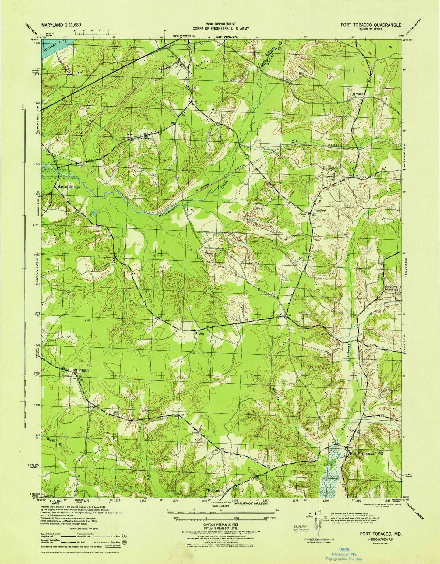
Classic USGS Port Tobacco Maryland 7.5'x7.5' Topo Map
Couldn't load pickup availability
Historical USGS topographic quad map of Port Tobacco in the state of Maryland. Typical map scale is 1:24,000, but may vary for certain years, if available. Print size: 24" x 27"
This quadrangle is in the following counties: Charles, Prince George's.
The map contains contour lines, roads, rivers, towns, and lakes. Printed on high-quality waterproof paper with UV fade-resistant inks, and shipped rolled.
Contains the following named places: Port Tobacco Creek, Bennsville Siding, Chapman Point, Habre De Venture, Hoghole Run, Jennie Run, Mason Springs, Metropolitan Church, Myrtle Grove Wildlife Management Area, Old Womans Run, Pole Branch, Pomfret, Pomfret Siding, Pomonkey, Pomonkey School, Port Tobacco School, Saint John's Episcopal Chapel Cemetery, Saint Johns Chapel, Saint Josephs Church, Saint Katherines Church, Saint Marys Star of the Sea School, Smith Chapel, Port Tobacco, Bennsville, Buteaux Crossing, Chapman Landing, Green Meadows, Knotts Crossing, Marshalls Corner, McConchie, Millards Mill, Mount Pisgah, Port Tobacco Riviera, Ripley, Rose Hill, Hawthorne Country Club, Myrtle Grove Lake Dam, Maryland Airport, Ty-Ti-To Airport, Avon Crest, Benville School (historical), Billingsley Forest, Blessed Hope Baptist Church, Caernarvon Woods, Camelot, Charles County Community College, Charles County Museum, Robert D Stethem Educational Center, Columbia Park, Countryside, Ellerslie Heights, Foxhall Estates, Freedom Village, Garden Estates, Graystone Estates, Hawthorne, Hawthorne Manor, Highland Estates, Horizon Center, J C Parks Elementary School, Doctor James Craik Elementary School, King George Estates, Laurel Acres, Matthew Henson Middle School, Maurice J McDonough High School, Metropolitan United Methodist Church Cemetery, Montrose, Mount Carmel, Mount Carmel Cemetery, Mount Carmel Estates, Myrtle Grove Estates, Nelson, Oakwood, Pomfret Post Office, Port Tobacco Courthouse Historic Site, Port Tobacco Hills, Port Tobacco Lakes, Port Tobacco Post Office, Quiet Acres, Port Tobacco Historic District, Robie Manor, Saint Josephs Cemetery, Saint Catherines of Alexandria Cemetery, Shady Acres, Smith Chapel Cemetery, Tarrington Creek, Twinbrook Estates, Valley View, Pomfret Estates, Thomas Stone National Historic Site, District 7 Pomonkey, Civista Health Center, Bryans Road Volunteer Fire Department and Rescue Squad, Bensville Census Designated Place, Bryans Road Census Designated Place, Town of Port Tobacco Village, Finagin Airfield, Charles County Public Library - Potomac Branch, Mattawoman Wastewater Treatment Plant, Pomfret Census Designated Place, Port Tobacco Creek, Bennsville Siding, Chapman Point, Habre De Venture, Hoghole Run, Jennie Run, Mason Springs, Metropolitan Church, Myrtle Grove Wildlife Management Area, Old Womans Run, Pole Branch, Pomfret, Pomfret Siding, Pomonkey, Pomonkey School, Port Tobacco School, Saint John's Episcopal Chapel Cemetery, Saint Johns Chapel, Saint Josephs Church, Saint Katherines Church, Saint Marys Star of the Sea School, Smith Chapel, Port Tobacco, Bennsville, Buteaux Crossing, Chapman Landing, Green Meadows, Knotts Crossing, Marshalls Corner, McConchie, Millards Mill, Mount Pisgah, Port Tobacco Riviera, Ripley, Rose Hill, Hawthorne Country Club, Myrtle Grove Lake Dam, Maryland Airport, Ty-Ti-To Airport, Avon Crest, Benville School (historical), Billingsley Forest, Blessed Hope Baptist Church, Caernarvon Woods, Camelot, Charles County Community College, Charles County Museum, Robert D Stethem Educational Center, Columbia Park, Countryside, Ellerslie Heights, Foxhall Estates, Freedom Village, Garden Estates, Graystone Estates, Hawthorne, Hawthorne Manor, Highland Estates, Horizon Center, J C Parks Elementary School, Doctor James Craik Elementary School, King George Estates, Laurel Acres, Matthew Henson Middle School, Maurice J McDonough High School, Metropolitan United Methodist Church Cemetery, Montrose, Mount Carmel, Mount Carmel Cemetery, Mount Carmel Estates, Myrtle Grove Estates, Nelson, Oakwood, Pomfret Post Office, Port Tobacco Courthouse Historic Site, Port Tobacco Hills, Port Tobacco Lakes, Port Tobacco Post Office, Quiet Acres, Port Tobacco Historic District, Robie Manor, Saint Josephs Cemetery, Saint Catherines of Alexandria Cemetery, Shady Acres, Smith Chapel Cemetery, Tarrington Creek, Twinbrook Estates, Valley View, Pomfret Estates, Thomas Stone National Historic Site, District 7 Pomonkey, Civista Health Center, Bryans Road Volunteer Fire Department and Rescue Squad, Bensville Census Designated Place, Bryans Road Census Designated Place, Town of Port Tobacco Village, Finagin Airfield, Charles County Public Library - Potomac Branch, Mattawoman Wastewater Treatment Plant, Pomfret Census Designated Place, Port Tobacco Creek, Bennsville Siding, Chapman Point, Habre De Venture, Hoghole Run, Jennie Run, Mason Springs, Metropolitan Church, Myrtle Grove Wildlife Management Area, Old Womans Run, Pole Branch, Pomfret, Pomfret Siding, Pomonkey, Pomonkey School, Port Tobacco School, Saint John's Episcopal Chapel Cemetery, Saint Johns Chapel, Saint Josephs Church, Saint Katherines Church, Saint Marys Star of the Sea School, Smith Chapel, Port Tobacco, Bennsville, Buteaux Crossing, Chapman Landing, Green Meadows, Knotts Crossing, Marshalls Corner, McConchie, Millards Mill, Mount Pisgah, Port Tobacco Riviera, Ripley, Rose Hill, Hawthorne Country Club