
MyTopo
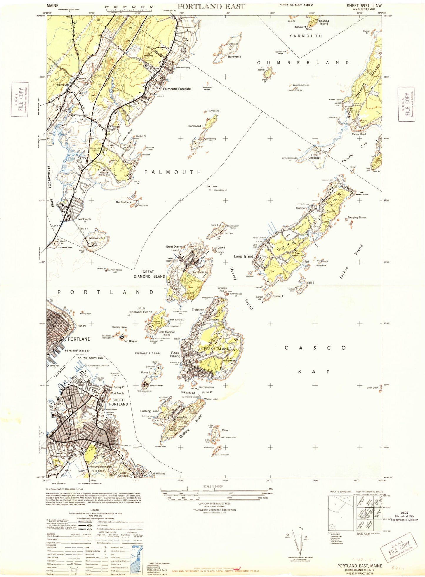
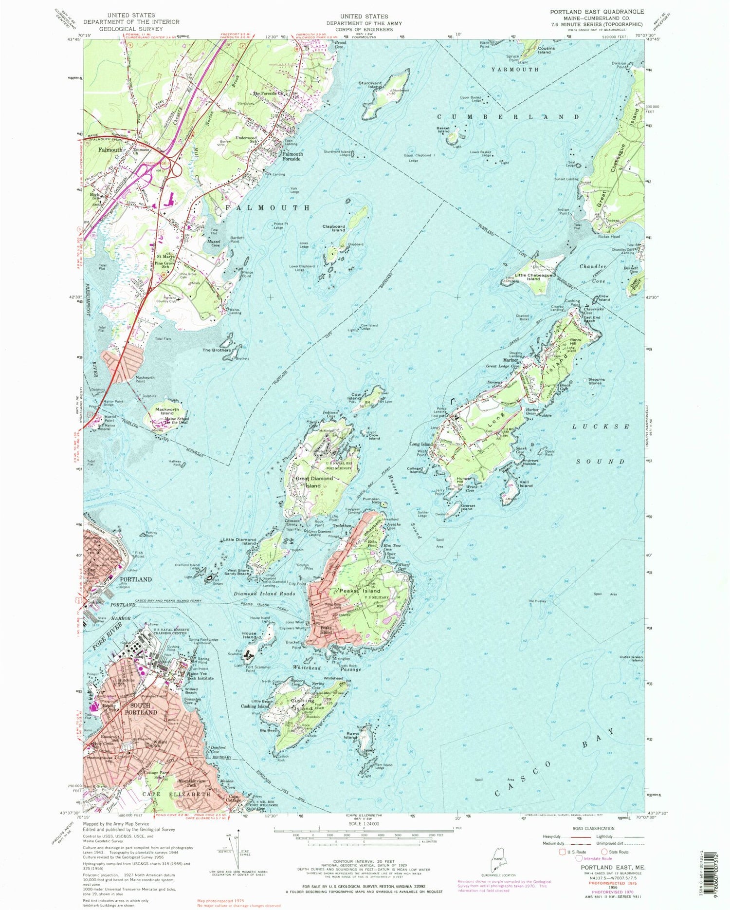
Classic USGS Portland East Maine 7.5'x7.5' Topo Map
Couldn't load pickup availability
Historical USGS topographic quad map of Portland East in the state of Maine. Typical map scale is 1:24,000, but may vary for certain years, if available. Print size: 24" x 27"
This quadrangle is in the following counties: Cumberland.
The map contains contour lines, roads, rivers, towns, and lakes. Printed on high-quality waterproof paper with UV fade-resistant inks, and shipped rolled.
Contains the following named places: Andrews Beach, Andrews Nubble, Bartlett Point, Basket Island, Beach Cove, Bennett Cove, Big Beach, Brackett Point, Broad Cove, Cape Cottage, Casco Bay Ferry, Catfish Rock, Chandler Cove, Channel Rocks, Chenery Brook, Chivericks Cove, City Point, Clapboard Island, College Island, Cottage Farm School, Cow Island, Cow Island Ledge, Crow Island, Crow Island, Cushing Point, Cushing Point, Danford Cove, Deer Point, Diamond Cove, Diamond Island Ledge, Diamond Island Roads, Division Point, Dorseys Cove, East End, East End Beach, Echo Point, Echo Pond, Elm Tree Cove, Emerson School, Emmaus Lutheran Church, Engineers Wharf, Falmouth, Falmouth Foreside, Fish Point, Fore River, Fort Allen Park, Fort Hill, Fort Scammel Point, Great Diamond Island, Great Ledge Cove, Hadlock Cove, Halfway Rock, Harbor Grace, Henley School, Holy Cross School South Portland, House Island, House Island Light, Hunger Hill, Hussey Sound, Hutchins School, Indian Cove, Indian Point, Jerry Point, Jones Ledge, Josiahs Cove, Kimball Brook, Lamson Cove, Little Beach, Little Chebeague Island, Little Diamond Island, Long Cove, Long Island, Long Island, Lower Basket Ledge, Lower Clapboard Island Ledge, Luckse Sound, Maiden Cove, Governor Baxter School for the Deaf, Southern Maine Community College - South Portland Campus, Mariner, Martin Point, Martin Point Bridge, Meetinghouse Hill, Mill Creek, Mount Pleasant Cemetery, Mountainview Park, Munjoy Hill, Mussel Cove, Norton Brook, Nubble, Obeds Rock, Overset Island, Peaks Island, Peaks Island Ferry, Pine Grove Cemetery, Pine Grove Child Development Center School, Pomroy Rock, Pond Grove Cemetery, Portland Harbor, Presumpscot River, Prince Point, Prince Point Ledge, Prospect Hill, Pumpkin Nob, Ram Island, Ram Island Ledge, Ricker Head, Rock Point, Rohrs Hill, Roosevelt School, Saint Mary the Virgin Episcopal Church, Scitterygusset Creek, Seal Cove, Seal Ledge, Shark Cove, Ship Cove, Simonton Cove, Soldier Ledge, South Portland, Spar Cove, Spicers Cove, Spring Cove, Spring Point, Spring Point Ledge Lighthouse, Spruce Point, State Pier, Stepping Stones, Sturdivant Island, Sturdivant Island Ledges, The Brothers, Foreside Community Church, The Hussey, Torrington Point, Trefethen, Trotts Rock, Trout Brook, Underwood School, United States Marine Hospital, Upper Basket Ledge, Upper Clapboard Island Ledge, Vaill Island, West Point, West Shore Sandy Beach, Whaleback, Wharf Cove, Whitehead Passage, Willard Beach, Willard School, Willard Square, Wreck Cove, York Ledge, Fish Point Ledge, Mackworth Island, Chandler Cove Landing, Cleaves Landing, Cushing Island, Doughty Landing, Evergreen Landing, Fort Gorges, Fort Levett, Fort Lyon, Fort Preble, Fort Scammel, Great Diamond Island Landing, Jones Wharf, Little Diamond Island Landing, Ponce Landing, Sunset Landing, Waites Landing, York Landing, Diamond Island Pass, Forest City Landing, Whitehead, Cushing Island, Mackworth Point, Peaks Island, Portland Country Club, Mariner Ledge, Ponce Ledge, Underwood Ledge, City of Portland, Basket Island Light, Basket Island Preserve, Breakwater Marina, Brown Elementary School, Cape Cottage Post Office, Cape Shore Assembly of God Church, Casco Bay Terminal, Centerboard Yacht Club, Channel Crossing Marina, Chebeague Island School, Church of the Servant, Clapboard Island Light, Cliff House Beach, Crow Island Light, Cushing Island Landing (historical), Custom House Wharf, D W Lunt School (historical), Falmouth Memorial Building, Falmouth Town Forest, Falmouth Shopping Center, Ferry Village, First Civic Monument, First Congregational Church, Foreside Community Cemetery, Forrest City Landing, Fort McKinley Historic District, Governor Baxter School for the Deaf Library, Green Memorial African Methodist Episcopal Zion Church, Hill School, Hog Island Ledge, Holy Cross Church, Holy Martyrs Church, Jones Landing Marina, Little Diamond Island Light, Little Diamond Island Observatory, Long Island Elementary School, Loveitts Field, Maine State Pier, Marada Adams School, Marine Shipyard, McKinley Estates, Narrow Gauge Railroad Museum, Old Settlers Cemetery, Peak's Island Post Office, Portland Public Library Peaks Island Branch, Peaks Island Marina, Peaks Island Elementary School, Peoples United Methodist Church, Pine Grove Child Development Center, Plummer-Motz School (historical), Portland Breakwater Light, Portland Harbor Museum, Portland Municipal Boat Launch, Portland Observatory, Portland Yacht Services Complex