MyTopo
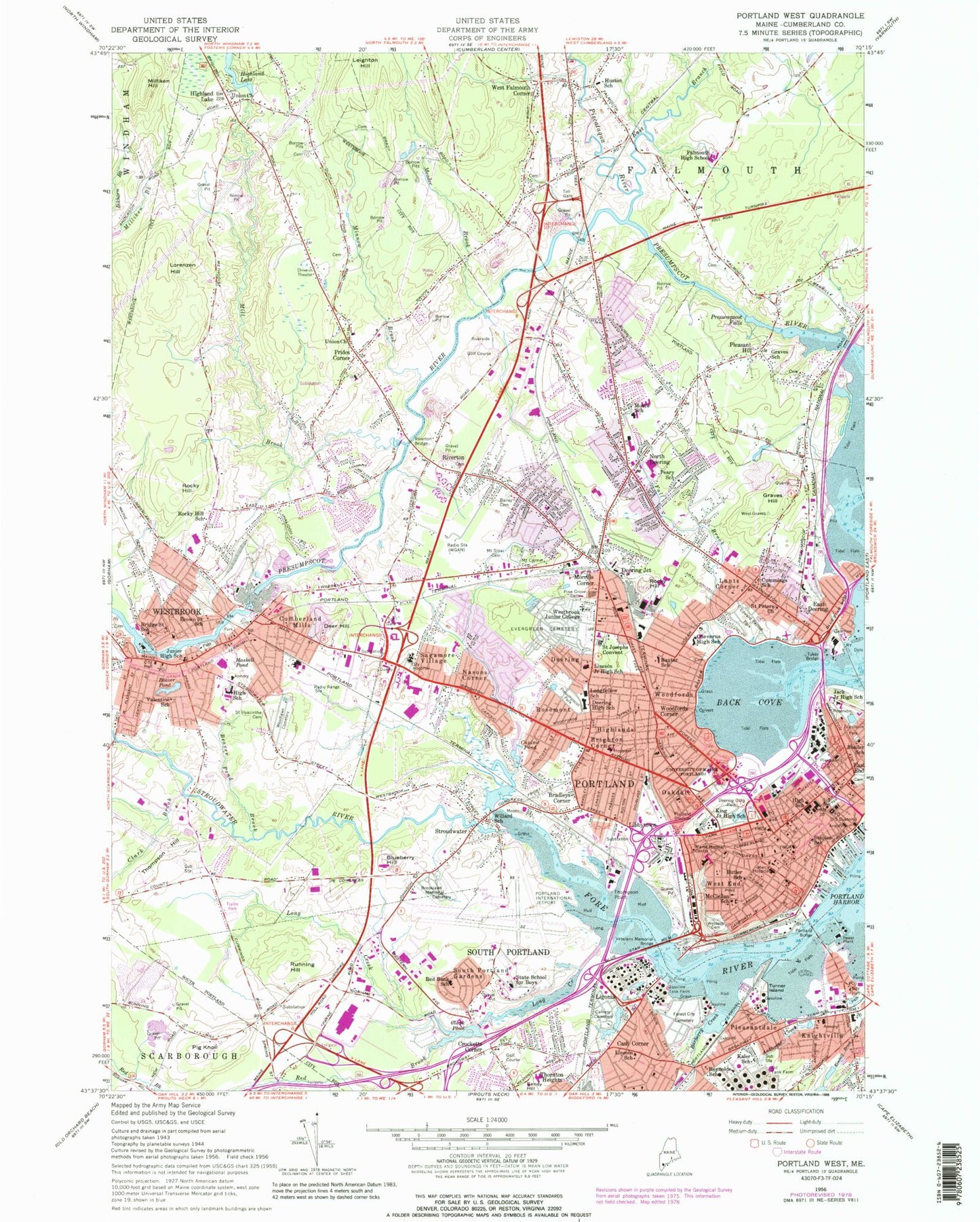
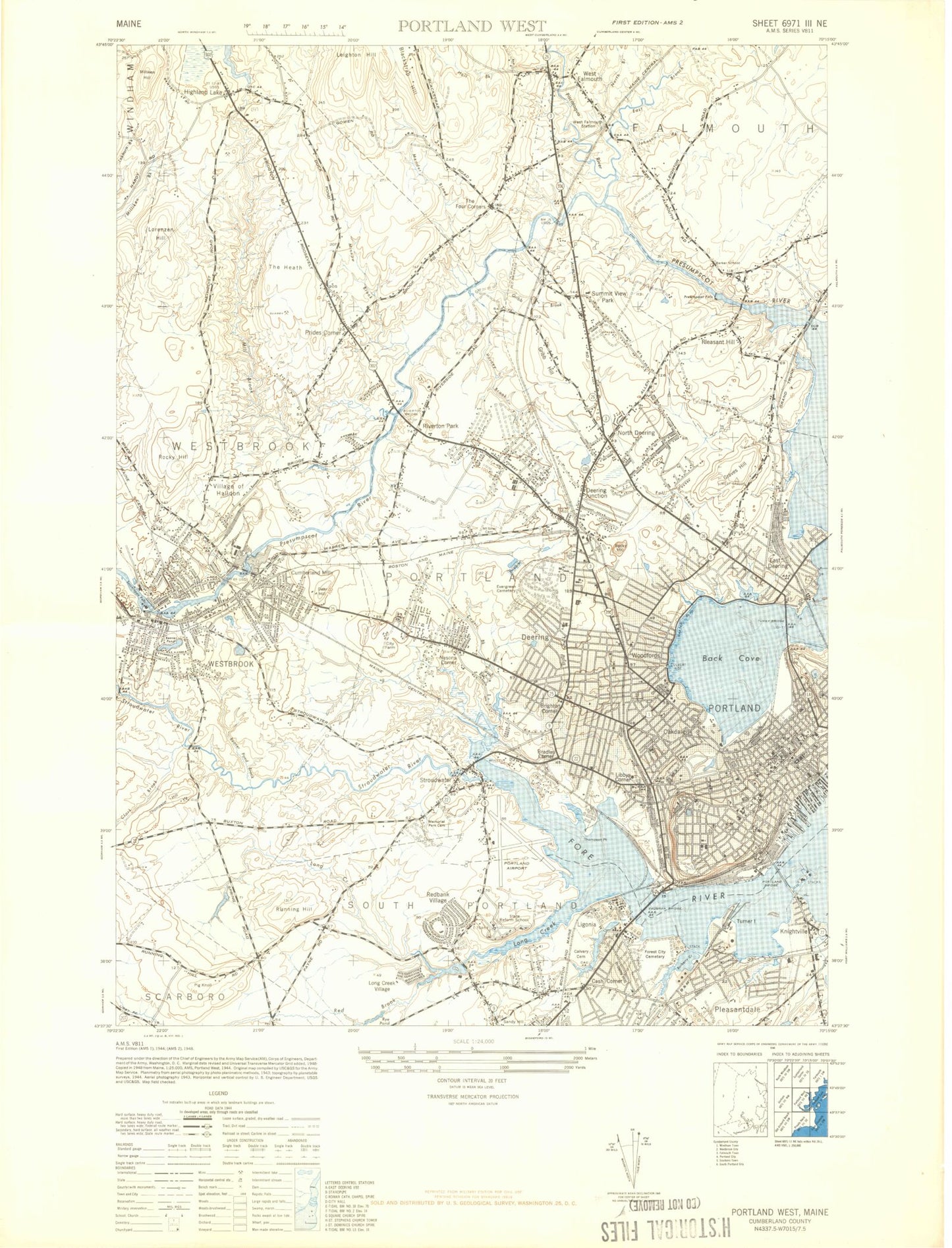
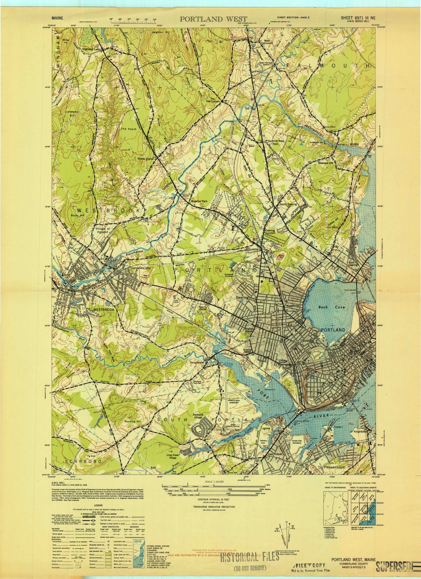
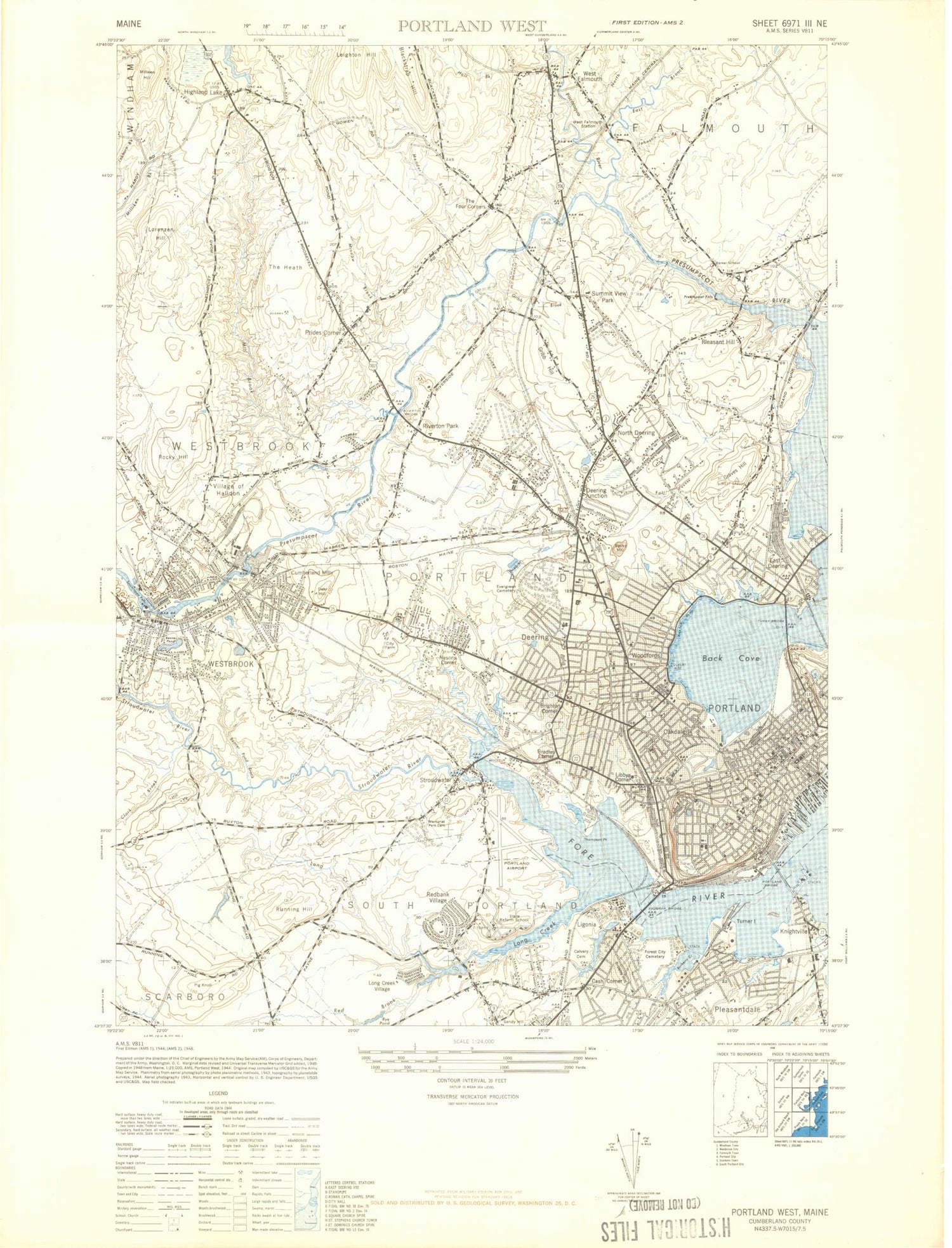
Classic USGS Portland West Maine 7.5'x7.5' Topo Map
Couldn't load pickup availability
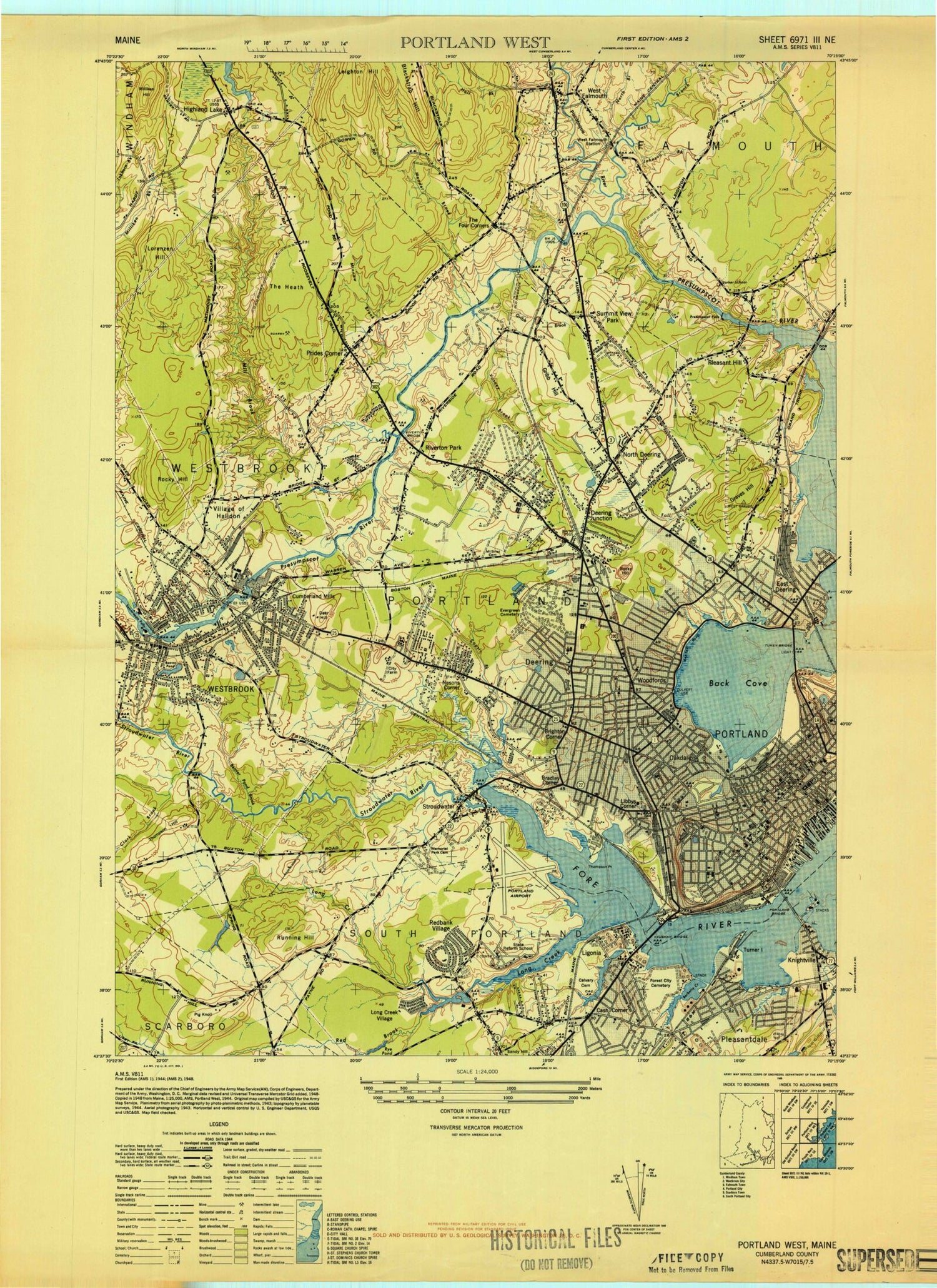
Historical USGS topographic quad map of Portland West in the state of Maine. Typical map scale is 1:24,000, but may vary for certain years, if available. Print size: 24" x 27"
This quadrangle is in the following counties: Cumberland.
The map contains contour lines, roads, rivers, towns, and lakes. Printed on high-quality waterproof paper with UV fade-resistant inks, and shipped rolled.
Contains the following named places: Anthoine Creek, Back Cove, Bailey Cemetery, Barberry Creek, Ocean Avenue School, Beaver Pond, Beaver Pond Brook, Blueberry Hill, Bradleys Corner, Bridge Saint School, Brighton Corner, Brooklawn Memorial Cemetery, Brown Saint School, Butler School, Calvary Cemetery, Capisic Pond, Cash Corner, Cheverus High School, Clark Brook, Clark Pond, Crocketts Corner, Cumberland Mills, Cummings School, Deer Hill, Deering, Deering High School, Deering Oaks Park, East Branch Piscataqua River, East Deering, Eastern Cemetery, Edward Payson Park, Evergreen Cemetery, Fall Brook, Falmouth High School, Forest City Cemetery, Graves Hill, Graves School, Haskell Pond, Highland Lake, Highlands, Huston School, Jack Junior High School, James Otis Kaler Elementary School, King Middle School, Knightville, Leighton Hill, Ligonia, Lincoln Middle School, Greater Portland Christian School, Long Creek, Longfellow Elementary School, Lorenzen Hill, Lunts Corner, Maine Medical Center, Waynflete School, Meader Brook, Northern Light Mercy Hospital - State Street, Mill Brook, Milliken Hill, Minnow Brook, Lyman Moore Middle School, Morrills Corner, Mount Carmel Cemetery, Mount Sinai Cemetery, Nasons Corner, North Deering, Oakdale, Peary School, Pig Knoll, Pine Grove Cemetery, Piscataqua River, Pleasant Hill, Pleasantdale, Portland Bridge, Portland, Presumpscot Falls, Presumpscot Park, Prides Corner, Redbank Village School, Red Brook, Reynolds School, Riverton, Riverton Bridge, Rocky Hill, Rocky Hill, Rocky Hill School, Rosemont, Running Hill, Sagamore Village, Saint Hyacinth Cemetery, Saint Josephs Convent, Saint Peters Episcopal Church, Shailer School, Small Brook, South Portland Gardens, Staples School, State School for Boys, Stroudwater, Stroudwater River, Thompson Hill, Thompson Point, Tukey Bridge, Turner Island, Union Church, Highland Lake Congregational Church, University of Southern Maine at Portland, Valentine School, Veterans Memorial Bridge, West End, West Falmouth Corner, Westbrook, University of New England Westbrook College, Western Cemetery, Willard School, Woodfords, Woodfords Corner, Woodlawn Cemetery, Deering Junction, WPOR Radio Tower (Havre De Grace), Libbytown, Standpine Park, Portland Stadium, Riverside Golf Course, WGAN Radio Tower (Havre De Grace), WLOB-AM (Portland), WGAN-AM (Portland), WBAE-AM (Portland), WLPZ-AM (Westbrook), WMGX-FM (Portland), WYNZ-FM (Westbrook), Portland International Jetport, Super Cub Field (historical), Town of Falmouth, City of South Portland, City of Westbrook, Cumberland Dam, Presumpscot River Reservoir, Saccarappa Dam, Highland Lake Dam, Stroudwater Dam, Stroudwater River Reservoir, Clark Pond Dam, African International Church, Allen Avenue Unitarian Universalist Church, Alumni House, Kaplan University - South Portland Campus, Andover College Library, Long Creek Youth Development Center - Arthur R Gould School, Assembly of God Church, Back Cove Historic District, Back Cove Park, Bangor Theological Seminary, Barker School (historical), Baxter Pines, Baxter Woods, Beautiful Savior Lutheran Church, Blackstrap Hill, Boothby Square, Bradles Plaza Shopping Center, Breakwater School, Bridgton Medical Center, Browns Wharf, Portland Public Library Burbank Branch, Calvary Chapel, Cape Elizabeth Methodist Church, Casco Bay Montessori School, Cathedral of the Immaculate Conception, Cathedral School (historical), Catherine McAuley High School, Central Square Baptist Church, Chamber of Commerce of the Greater Portland Region, Chandlers Wharf, Chestnut Street United Methodist Church, Christ Church, Church of the Holy Spirit, Church of the Holy Spirit Episcopal Church, Clark Memorial United Methodist Church, Nathan and Henry B Cleaves Law Library, Cobb Cemetery, Conant Cemetery, Congin School, Congress Square, Congress Square Park, Cornerbrook Shopping Center, Cumberland County Civic Center, Cumberland County Courthouse, Cumberland Mills Historic District, Cumberland Wharf, Danforth Gallery, Deering Street Historic District, University of Maine School of Law Garbrecht Law Library, Eckankar Religion of Light Church, Elm Street United Methodist Church, Emmanuel Assembly of God Church, Faith House Womans Shelter, Falmouth Congregational Church, Falmouth Town Hall, Feminist Spiritual Community, First Baptist Church, First Parish Unitarian Church, First Baptist Church, First Baptist Church, First Church of Christ, Fore River Sanctuary, Forest Avenue Plaza Shopping Center, Fort Allen Park, Fort Sumner Park, Frances W Peabody Research Library, Fred Wescott School, Rowe Elementary School, Friends Cemetery, Friends Meeting House, Garrison Hills Estates, Bangor Theological Seminary Portland, George I Lewis and Family Gallery, George Street Cemetery, Glenwood Square Baptist Church, University of Southern Maine Glickman Family Library, Gowen Family Cemetery, Grace Baptist Church, Grand Trunk Cemetery, Greater Portland Christian School, Greater Portland Council of Governments, Grubb Hill (historical), Hadlock Field, Hale Cemetery, Hamlin Elementary School, Hardy Cemetery (historical), Harrison Lyseth Elementary School, Henry Wadsworth Longfellow Monument, Highland Lake Cemetery, Highland Lake Church Cemetery, Hinckley Park, Hobsons Wharf, Holy Trinity Greek Orthodox Church, Howard C Reiche Community School