MyTopo
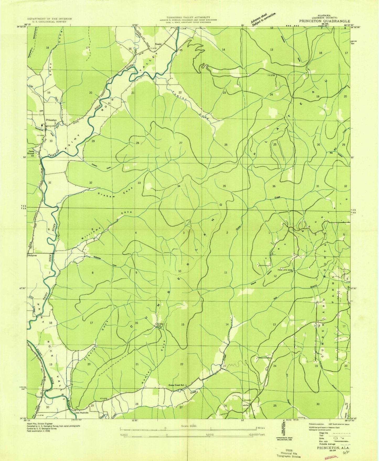
Classic USGS Princeton Alabama 7.5'x7.5' Topo Map
Couldn't load pickup availability
Historical USGS topographic quad map of Princeton in the state of Alabama. Typical map scale is 1:24,000, but may vary for certain years, if available. Print size: 24" x 27"
This quadrangle is in the following counties: Jackson.
The map contains contour lines, roads, rivers, towns, and lakes. Printed on high-quality waterproof paper with UV fade-resistant inks, and shipped rolled.
Contains the following named places: Basham Hollow, Beason Spring, Bee Branch, Big Bend, Big Hollow, Bill Hollow, Black Gum Hollow, Blessington Point, Blue Spring, Bouldin Point, Brewer Hollow, Caney Hollow, Church Hill Cemetery, Clay Cemetery, Cowan Hollow, Dry Creek, Eddy Cove, Fork Mountain, Fowler Cemetery, Fowler Cove, Fowler Narrows, Frazier Cove, Graham Cemetery, Graham Cove, Green Cemetery, Guess Creek Church, Horseshoe Bend, Indian Grave Pond, Jacobs Mountain, Latham Cemetery, Latham Narrows, Letcher, Lick Fork, Little Nashville Point, Logan Point, Mill Creek, Neely Branch, Pole Branch, Poplar Hollow, Prince Cemetery, Robertson Cove, Robertson Spring, Round Knob, Rutledge Point, Saltpeter Cove, Sampson Point, Sand Bluff, Shop Hollow, Slipoff Hollow, Stovall Hollow, Thompson Cove, Threwer Point, Williams Cove, Winding Stairs, Beachboro (historical), Fork Mountain Mine, Guess Creek School (historical), Jacobs Mine Number 2, Paint Rock Valley High School, Salt Peter Hollow, Rouse Cemetery, Hunter Hollow, Princeton, Princeton Church, Williams Cove Church, Larkin Fork, Mountain View Baptist Church, Baileytown, Little Nashville, Swaim, Mount Zion Church, Princeton Division, Larkins Fork (historical), Larkin Fork Post Office, Jacobs Mine, Holly Grove Church, Skyline Volunteer Fire Department Station 2, Valley Volunteer Fire Department Station 1, Skyline Volunteer Fire Department Station 3, Princeton Post Office, Basham Hollow, Beason Spring, Bee Branch, Big Bend, Big Hollow, Bill Hollow, Black Gum Hollow, Blessington Point, Blue Spring, Bouldin Point, Brewer Hollow, Caney Hollow, Church Hill Cemetery, Clay Cemetery, Cowan Hollow, Dry Creek, Eddy Cove, Fork Mountain, Fowler Cemetery, Fowler Cove, Fowler Narrows, Frazier Cove, Graham Cemetery, Graham Cove, Green Cemetery, Guess Creek Church, Horseshoe Bend, Indian Grave Pond, Jacobs Mountain, Latham Cemetery, Latham Narrows, Letcher, Lick Fork, Little Nashville Point, Logan Point, Mill Creek, Neely Branch, Pole Branch, Poplar Hollow, Prince Cemetery, Robertson Cove, Robertson Spring, Round Knob, Rutledge Point, Saltpeter Cove, Sampson Point, Sand Bluff, Shop Hollow, Slipoff Hollow, Stovall Hollow, Thompson Cove, Threwer Point, Williams Cove, Winding Stairs, Beachboro (historical), Fork Mountain Mine, Guess Creek School (historical), Jacobs Mine Number 2, Paint Rock Valley High School, Salt Peter Hollow, Rouse Cemetery, Hunter Hollow, Princeton, Princeton Church, Williams Cove Church, Larkin Fork, Mountain View Baptist Church, Baileytown, Little Nashville, Swaim, Mount Zion Church, Princeton Division, Larkins Fork (historical), Larkin Fork Post Office, Jacobs Mine, Holly Grove Church, Skyline Volunteer Fire Department Station 2, Valley Volunteer Fire Department Station 1, Skyline Volunteer Fire Department Station 3, Princeton Post Office