MyTopo
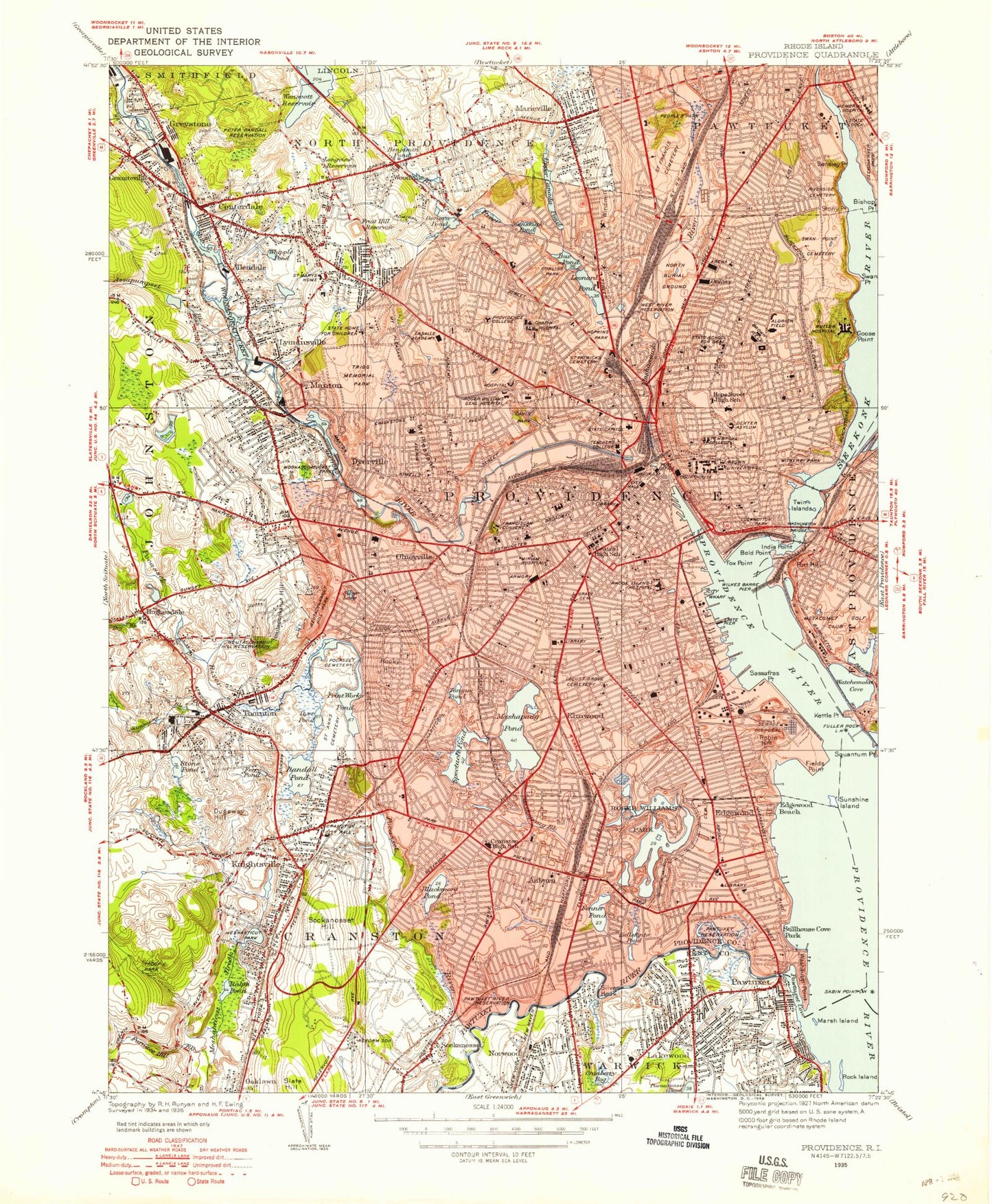
Classic USGS Providence Rhode Island 7.5'x7.5' Topo Map
Couldn't load pickup availability
Historical USGS topographic quad map of Providence in the state of Rhode Island. Typical map scale is 1:24,000, but may vary for certain years, if available. Print size: 24" x 27"
This quadrangle is in the following counties: Kent, Providence.
The map contains contour lines, roads, rivers, towns, and lakes. Printed on high-quality waterproof paper with UV fade-resistant inks, and shipped rolled.
Contains the following named places: Lakewood, Furnace Hill Brook, Oaklawn, Garden City, Pocasset River, Norwood, Cranberry Bog, Pawtuxet, Pawtuxet River, Pawtuxet Neck, Marsh Island, Meshanticut, Sockanosset Hill, Knightsville, Cranston, Auburn, Fenner Pond, Bellefont Pond, Silver Hook, Deep Spring Lake, Cunliff Lake, Edgewood Lake, Edgewood, Fields Point, Kettle Point, Pleasure Lake, Roosevelt Lake, Polo Lake, Elmwood, Spectacle Pond, Tongue Pond, Print Works Pond, Randall Pond, Dyer Pond, Thornton, Stone Pond, Dugaway Hill, Simmons Brook, Dry Brook, Hughesdale, Neutaconkanut Hill, Rocky Hill, Sassafras Point, Watchemoket Cove, Fort Hill, Providence Harbor, Olneyville, Dyerville, Mount Pleasant, Fox Point, India Point, Crook Point, Red Bridge, Cold Spring Point, Blackstone Pond, York Pond, Goose Point, Seekonk River, Moshassuck River, Bradley Hill, Manton, Lymansville, Assapumpset Brook, Allendale, Centerdale, Longview Reservoir, Woodville, Canada Pond, Windmill Hill, Swan Point, Stony Point, Bensley Point, Woodlawn, Marieville, Greystone, Esmond, Pawtuxet Cove, Woonasquatucket River, Mashapaug Pond, Bold Point, Wenscott Reservoir, Promet Airport (historical), Downtown Providence Helistop, One Hospital Trust Airport, Cunliff Pond Dam, Cranston Print Works Pond, Cranston Print Works Pond Dam, Lyman Mill Pond, Lymansville Dam, Allendale Pond Dam, Canada Upper Pond Dam, Wenscott Reservoir Dam, Silver Hook, Wanskuck, Geneva, Burges Cove, Corliss Cove, Benedict Pond (historical), Long Pond (historical), Friends School, Dexter Asylum, Fruit Hill, Merino, Pocasset, Sockanosset, Wayland, Bellefonte (historical), Blackamore Pond, Fruit Hill, North Providence, Star Island, Manton Pond, Mashapaug Brook, Pancake Island, Metacomet Brook, Centerdale Mill Pond, Cranston Print Works, Copps Cove, Eden Park, Blackstone Park, Allendale Mill Pond, Fuller Rock, Flower Island, Providence River, Bucklin Park, Forys Playground, Saint Francis Cemetery, North Burial Ground, Holy Name of Jesus School, Rhode Island State School for the Deaf, Nathan Bishop Middle School, Moses Brown Prepatory School, Hope High School, Prospect Terrace Park, Pembroke College, Whitherby Park, Brown University, Bryant College, Fox Point School, Tockwotton Park, Wiles Barre Pier, Columbia Park, Saint Pauls School, Edward S Rhodes School, Pawtuxet Reservation, Fay Memorial Field, Sanders School, Park View Middle School, Chester W Barrows School, Saint Matthews School, Rogers Williams Park, Sackett Street School, Saint Elizabeth Home, Lexington Avenue School, Locust Grove Cemetery, Saint Michaels Schools, Thurber Avenue School, Roger Williams Middle School, Oxford Street School, Edmund W Flynn School, Beacon Avenue School, Rhode Island Hospital, Samuel W Bridgham Middle School, Saints Peter and Paul Cathedral, Kenyon Street School, Conlan Junior Memorial Park, Classical High School, Saint Patricks High School, Saint Patricks School, Saint Patrick's Cemetery, Hopkins Park, Esek Hopkins Middle School, Daniel D Waterman School, Eden Park School, Pawtuxet River Reservation, Windmill Street School Annex Number 1, Monsigner Bove School, Windmill Street School, Wanskuck Park, Williams Church, Saint Edwards School, Robert F Kennedy School, Ruggles Street School, Elmhurst Academy, Veazie Street School, Providence College, Chapin Hospital, Davis Park, O Brian Memorial Park, Academy Avenue School, Women and Infants Hospital of Rhode Island, Greene High School, Roger Williams Hospital, Grace Church Cemetery, Saint Joseph Health Center, Lonigan Memorial Park, Saint Teresas High School, Hugh B Bain Middle School, Horton School, Dutemple School, Saint Charles School, Sons of David and Israel Cemetery, Cranston Stadium, Bennett Avenue School, Saint Bartholomews School, Russo Playground, Pocasset Cemetery, Gladstone Street School, Ralph Street School, Saint Anthonys School, Oliver Hazard Perry Middle School, Merino School, Woonasquatucket Park, Saint Thomas School, Saint Augustine School, Saint Marys Home, Franciscan Missionaries of Mary, Trigg Memorial Park, Mount Pleasant High School, Rhode Island State Home for Children, LaSalle Academy, University of Rhode Island, Louisquissett Golf Course, Our Lady of Fatima Hospital, George J West School, Heatherman Memorial Park, Saint Ann's Cemetery, Harbor Junction Pier, Franciscan Convent, Dexter Training Ground, Metcalf Field, Copps Cave, Narragansett Yacht Club, Fox Point Reach, Fuller Rock Reach, Summit Ave School


