MyTopo
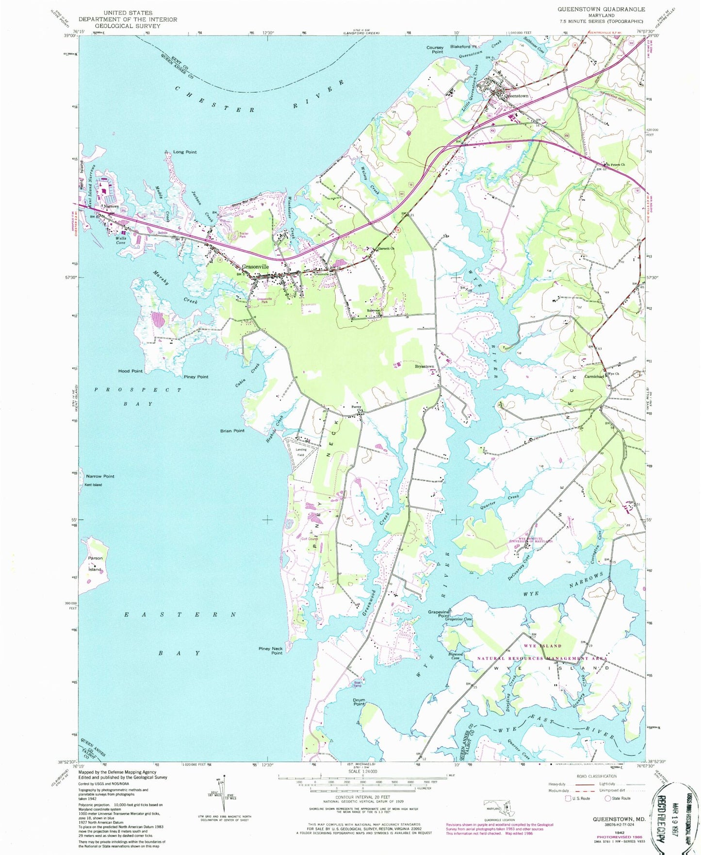
Classic USGS Queenstown Maryland 7.5'x7.5' Topo Map
Couldn't load pickup availability
Historical USGS topographic quad map of Queenstown in the state of Maryland. Map scale may vary for some years, but is generally around 1:24,000. Print size is approximately 24" x 27"
This quadrangle is in the following counties: Kent, Queen Anne's, Talbot.
The map contains contour lines, roads, rivers, towns, and lakes. Printed on high-quality waterproof paper with UV fade-resistant inks, and shipped rolled.
Contains the following named places: Anglers Marina, Aspen Institute, Beach Harbor Mobile Home Park, Belle Point Farm, Bennetts Point, Bigwood Cove, Blackbeards Bluff, Blair Woods, Blakeford Point, Bluff Point, Bowser Chapel, Brian Point, Browns Landing, Bryan Methodist Church Cemetery, Bryans Church, Bryantown, Cabin Creek, Calvary United Methodist Church, Carmichael, Cedar Point, Chesapeake Village Shopping Center, Chester River Beach, Cheston on the Wye, Church of Christ, Community Church, Country Acres, Coursey Point, Covington Cove, De Coursey Island, DeCoursey Cove, DeCoursey Island, District 5 Queenstown, Dividing Creek, Drum Point, East Prospect Plantation, Fisher Manor, Garnett Church, Governor Grayson Manor, Granary Creek, Grapevine Cove, Grapevine Point, Grasonville, Grasonville Cemetery, Grasonville Census Designated Place, Grasonville Elementary School, Grasonville Park, Grasonville Post Office, Grasonville Senior Center, Grasonville Seventh Day Adventist Church, Grasonville Volunteer Ambulance Service Station 20, Grasonville Volunteer Fire Department Station 2, Greenwood Creek, Guys, Hickory Ridge, Hoghole Creek, Hood Point, Horsehead Farm Wildlife Sanctuary, Immanuel United Methodist Church, Jackson Creek, Kent Island Narrows, Kent Narrows, Kent Narrows Census Designated Place, Lippincott Marine, Little Greenwood Creek, Little Queenstown Creek, Long Point, Mainbrace, Marshy Creek, Mears Point Marina, Muddy Creek, My Lords Gift, Narrow Point, Narrows, New Covenant Christian Academy, New Covenant Church, Overlook, Parsons Island, Perrey Church, Perrys Corner, Perrys Corner Cemetery, Piney Neck, Piney Neck Point, Piney Point, Prospect Bay, Prospect Bay Country Club, Quarter Creek, Queen Anne Woods, Queen Annes Acres, Queen Anne's Emergency Medical Center, Queen Annes Estates, Queen Annes on Wye, Queenstown, Queenstown Creek, Queenstown Harbor Golf Links, Queenstown Post Office, Queenstown Volunteer Fire Department Station 3, Queenstown Wastewater Treatment Plant, River Bend Estates, Robinson Church, Sadlers Cove, Saint Peters Cemetery, Saint Peters Church, Salthouse Cove, Sayers Forest, Sedgewick Cove, Sportsman Hall, Stony Bar Bluff, The Wye Episcopal Church, Town of Queenstown, University of Maryland - Wye Institute, Walsey Creek, Watersman, WBEY-FM (Grasonville), Wesley Creek, White House Acres, Wildfowl Discovery Center, Winchester Creek, Winchester Estates, Windward Cove, Woodbury Acres, Wye Acres, Wye Church, Wye Harbor, Wye Island, Wye Island Natural Resources Management Area, Wye Narrows, Wye Neck, Wye of Carmichael Cemetery, Wye River Farms, ZIP Codes: 21638, 21658