MyTopo
Classic USGS Quonochontaug Rhode Island 7.5'x7.5' Topo Map
Couldn't load pickup availability
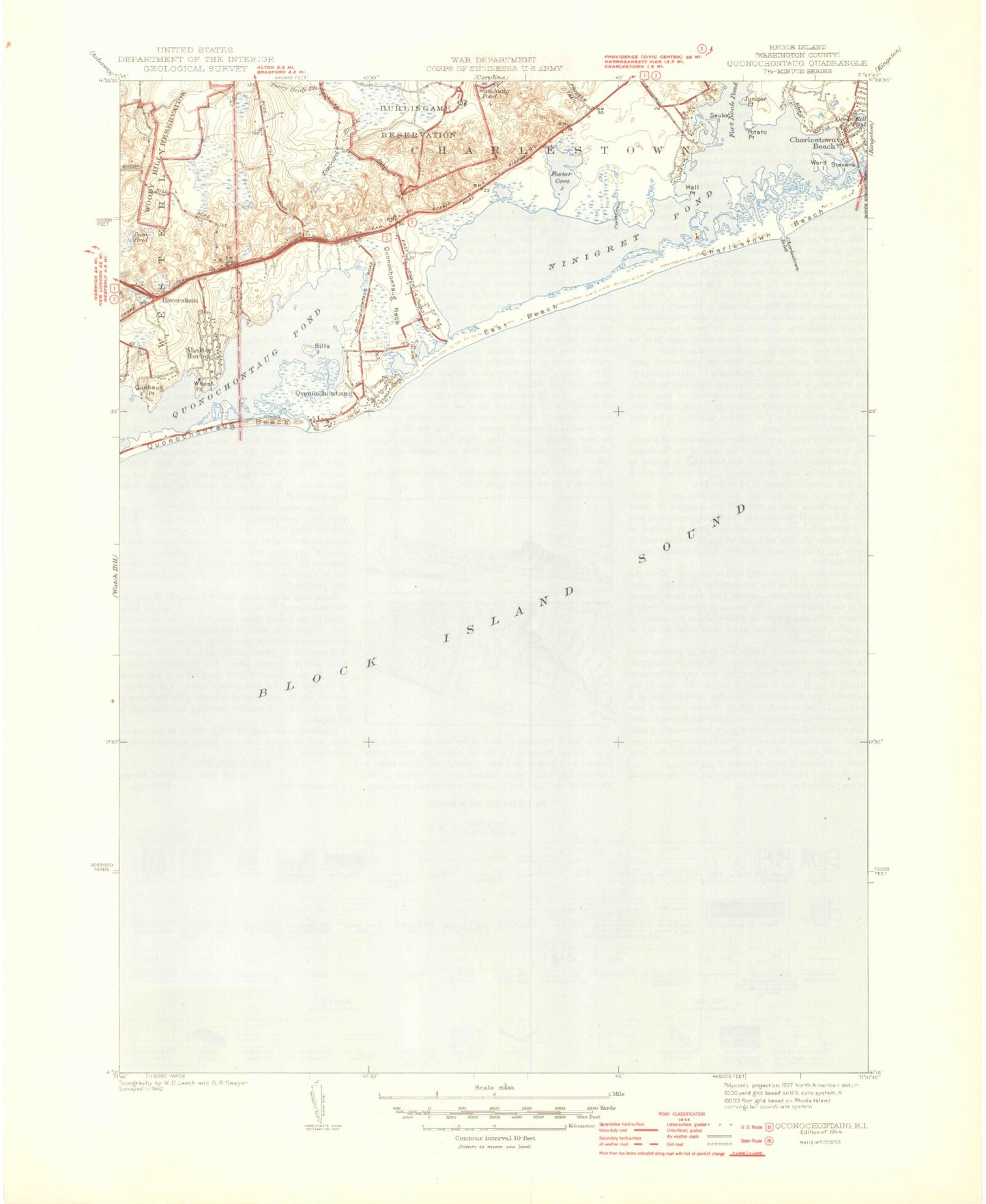
Historical USGS topographic quad map of Quonochontaug in the state of Rhode Island. Typical map scale is 1:24,000, but may vary for certain years, if available. Print size: 24" x 27"
This quadrangle is in the following counties: Washington.
The map contains contour lines, roads, rivers, towns, and lakes. Printed on high-quality waterproof paper with UV fade-resistant inks, and shipped rolled.
Contains the following named places: East Beach, Bills Island, Block Island Sound, Quonochontaug Breachway, Quonochontaug, Quahaug Point, Wheat Point, Shelter Harbor, Haversham, Dam Pond, Shady Harbor, Quonochontaug Neck, Reeds Point, Mud Cove, Foster Cove, Ninigret Pond, Coon Cove, Hall Point, Governors Island, Marshneck Point, Charlestown Breachway, The Hummocks, Potato Point, Marsh Point, Ward Island, Heather Island, Stevens Island, Willows Resort Airport (historical), Weekapaug Beach, Quonochontaug Beach (historical), Quonochontaug Pond, Burlingame Management Area, Woody Hill Management Area, Charlestown Beach, Charlestown Beach, Town of Charlestown, Children Cove, Charlestown Driving Range, First Baptist Church of Charlestown at Quonochontaug, General Stanton Monument, Saint Andrew Lutheran Church, Sam Ferretti Blue Shutters Town Beach, Weekapaug Yacht Club, Ninigret National Wildlife Refuge, Grassy Point, Ninigret State Conservation Area, Charlestown Naval Auxiliary Air Station (historical), Charlestown Police Department, Dunns Corner Fire Department Station No 2, Saint Andrew Preschool, Quonochontaug Beach, Quonochontaug Census Designated Place, Charlestown Ambulance Rescue Service, East Beach, Bills Island, Block Island Sound, Quonochontaug Breachway, Quonochontaug, Quahaug Point, Wheat Point, Shelter Harbor, Haversham, Dam Pond, Shady Harbor, Quonochontaug Neck, Reeds Point, Mud Cove, Foster Cove, Ninigret Pond, Coon Cove, Hall Point, Governors Island, Marshneck Point, Charlestown Breachway, The Hummocks, Potato Point, Marsh Point, Ward Island, Heather Island, Stevens Island, Willows Resort Airport (historical), Weekapaug Beach, Quonochontaug Beach (historical), Quonochontaug Pond, Burlingame Management Area, Woody Hill Management Area, Charlestown Beach, Charlestown Beach, Town of Charlestown, Children Cove, Charlestown Driving Range, First Baptist Church of Charlestown at Quonochontaug, General Stanton Monument, Saint Andrew Lutheran Church, Sam Ferretti Blue Shutters Town Beach, Weekapaug Yacht Club, Ninigret National Wildlife Refuge, Grassy Point, Ninigret State Conservation Area, Charlestown Naval Auxiliary Air Station (historical), Charlestown Police Department, Dunns Corner Fire Department Station No 2, Saint Andrew Preschool, Quonochontaug Beach, Quonochontaug Census Designated Place, Charlestown Ambulance Rescue Service