MyTopo
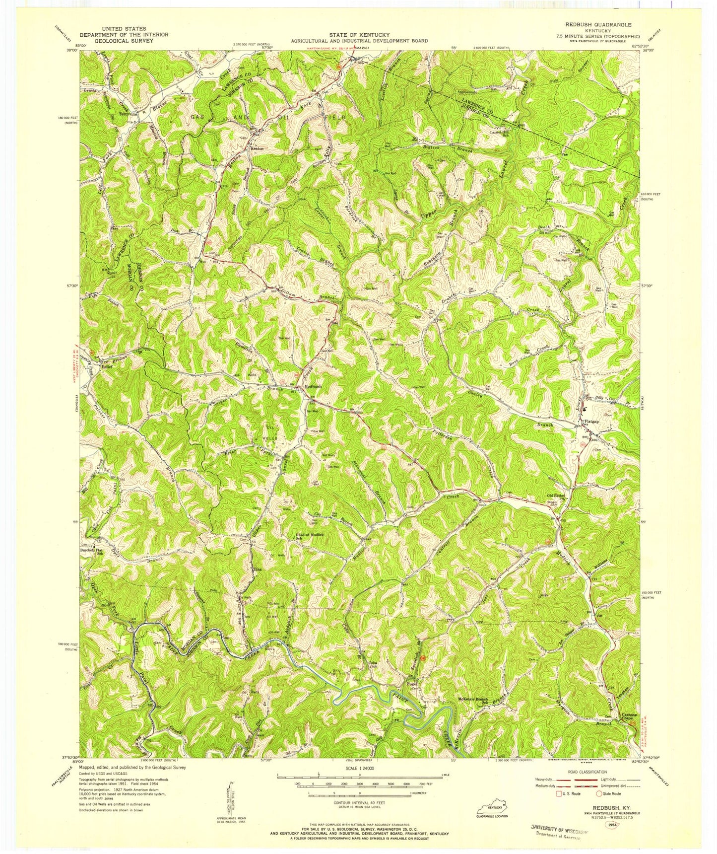
Classic USGS Redbush Kentucky 7.5'x7.5' Topo Map
Couldn't load pickup availability
Historical USGS topographic quad map of Redbush in the state of Kentucky. Map scale may vary for some years, but is generally around 1:24,000. Print size is approximately 24" x 27"
This quadrangle is in the following counties: Johnson, Lawrence, Morgan.
The map contains contour lines, roads, rivers, towns, and lakes. Printed on high-quality waterproof paper with UV fade-resistant inks, and shipped rolled.
Contains the following named places: Alum Dirt Branch, Andylick Branch, Ayersville Post Office, Barker Branch, Barnrock Branch, Beech Branch, Big Mine Fork, Biglick Branch, Billy Cox Branch, Brier Fork, Brig Post Office, Browns Branch, Burchett Flat School, Cannons Chapel, Cantrell Branch, Christian Union Enterprise Baptist Church, Coal Creek, Cold Springs Baptist Church, Conley Branch, Cox Branch, Cuba Branch, Cuba School, Dick Branch, Drakes Creek, Dyer Branch, Elna, Elna Post Office, Flatgap, Flatgap Division, Flatgap Post Office, Flatgap Volunteer Fire Department, Franks Creek, Fuget, Gillum Branch, Hamilton Branch, Head of Mudlick School, Jenkins Cemetery, Joe Salyer Branch, Joes Creek, Keaton, Keaton Fork, Keaton Fork Church of Jesus Christ, Kelly Branch, Lester Branch, Lewis Creek, Lewis Fork, Little Paint Creek, Little Paint School, Lost Creek, Low Gap Fork, Lower Sandlick Creek, Lyons Branch, Martha Pool Gas and Oil Field, Martha Ridge, McKenzie Branch, Meadow Branch, Mill Branch, Noisy Branch, Oil Springs Church, Old Bethel Church, Old Cold Springs United Baptist Church, Open Fork Paint Creek, Osborne Branch, Paint Valley Church, Paintsville Lake, Paintsville Lake Wildlife Area, Patoker Branch, Patterson Creek, Peaceful Valley Independent Baptist Church, Point Pleasant Church, Prince Branch, Red Bush Volunteer Fire Department, Red Bush Volunteer Fire Department Station 2, Redbush, Relief, Relief Post Office, Robinson Branch, Ross Creek, Salyer Branch, Salyers Cemetery, Spicelick Branch, Stone Coal Branch, Sturgeon Branch, Terryville, Terryville Post Office, Terryville School, The Open Fork of Paint United Baptist Church, Thomas Branch, Travis Branch, Upper Sandlick Creek, Vaughan Branch, Williams Branch, Win Post Office, Wolfpen Branch, ZIP Codes: 41219, 41226