MyTopo
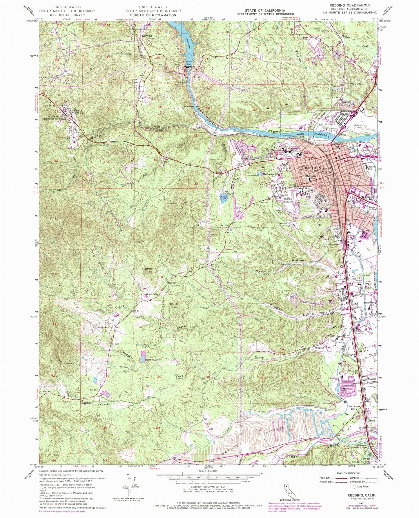
Classic USGS Redding California 7.5'x7.5' Topo Map
Couldn't load pickup availability
Historical USGS topographic quad map of Redding in the state of California. Map scale may vary for some years, but is generally around 1:24,000. Print size is approximately 24" x 27"
This quadrangle is in the following counties: Shasta.
The map contains contour lines, roads, rivers, towns, and lakes. Printed on high-quality waterproof paper with UV fade-resistant inks, and shipped rolled.
Contains the following named places: Alice Consolidated Mine, All Saints Episcopal Church, American Medical Response Station 1, Anderson-Cottonwood Diversion 51-000 Dam, Benton Field, Bethel Assembly of God Church, Black Diamond Mine, Black Spider Mine, Blue Bird Placer Mine, Blue Gravel Mine, Bonny View Elementary School, Bracket Mine, Buena Vista Mine, Bunker Hill Mine, California Highway Patrol Northern Division Headquarters, Canyon Hollow, Carlson and Sandburg Mine, Cascade Sanatorium, Centerville, Centerville Census Designated Place, Centerville Hydraulic Pits, Centerville Volunteer Fire Company Station 52, Church of Christ, Church of Jesus Christ, Clear Creek Gold Discovery Historical Marker, Clear Creek Hydraulic Pits, Clear Creek Mobile Home Park, Clear Creek Pit Number 1, Clear Creek Pit Number 2, Clear Creek School, Clear Creek Tailings Pit, Compton Mine, Corrine Mine, Crownpoint Mine, Cypress Elementary School, Del Oro Mine, Dixon and Cooper Mine, Downtown Redding Post Office, Eureka Tellurium Mine, Falks Lake, First Baptist Church, First Church of Christ Scientist, Flat Creek, Foursquare Church, George Reese Reservoir 225 Dam, Girvan, Gold Leaf Mine, Golden Chariot Mine, Grant Elementary School, Grant School, Hogtown, Hope So Mine, Horsetown Placer Mining Area, Hummingbird Mine, James Montgomery 1220 Dam, Jefferson Mine, Jenny Creek, Jensen Mine, Jubilee Mine, Juniper Academy School, Keswick, Keswick Census Designated Place, Keswick Dam, Keswick Dam Trailer Park, Keswick Hydraulic Pits, Keswick Reservoir, Keswick School, Keswick Volunteer Fire Company Shasta County Fire Station 53, Kett, Kett Pit, KEWB-FM (Anderson), KLXR-AM (Redding), KNNN-FM (Central Valley), Lake Boulevard Plaza Shopping Center, Lake Redding, Lake Redding Golf Course, Lake Redding Park, Lechner Mine, Live Oak School, Los Robles Estates, Magnolia Elementary School, Manzanita Elementary School, Manzanita Mine, Menning Golf Course, Mercy Medical Center Heliport, Mercy Medical Center Redding, Mercy Medical Ground Ambulance, Middle Creek, Middletown, Middletown Cemetery, Midnight Mine, Moose-horn Mobile Home Park, Mountain Shadows Mobile Home Estates, Mountain Top Mine, Northpoint Plaza Shopping Center, Nova High School, Old Redding City Hall Building, Old Spanish Mine, Oregon Gulch, Oro Grande Mine, Patients Hospital of Redding, Pine School, Pine Street School Shopping Center, Pioneer Continuation High School, Rattlesnake Mine, Reach Air Medical Services, Redding, Redding Convention Center, Redding Fire Department Station 1, Redding Fire Department Station 2, Redding Fire Department Station 3, Redding Fire Department Station 4, Redding Gun Club, Redding Memorial Park, Redding Museum and Art Center, Redding Oaks Mobile Home Park, Redding Police Department, Redding Rancheria, Reddingwood Mobile Home Park, Reese Reservoir, Riverside Mobile Park, Rock Creek, Rocky Point Charter School, Sacramento Pliocene Mine, Saddle Pocket Mine, Safari Mobile Home Park, Saint Joseph Cemetery, Saint Joseph School, Saint Joseph's Cemetery, Saint Josephs Roman Catholic Church, Salee Mine, Salt Creek, Salt Creek Mine, San Buena Ventura, Sequoia Middle School, Seventeen Hill, Shady Acres Trailer Park, Shady Oaks Mobile Park, Shasta, Shasta Census Designated Place, Shasta City Union Cemetery, Shasta County Courthouse, Shasta County Jail, Shasta County Library, Shasta County Sheriff Patrol Operations Main Redding Station, Shasta County Sheriff's Office Headquarters, Shasta Fire District Station 56, Shasta General Hospital, Shasta High School, Shasta Masonic Cemetery, Shasta Post Office, Shasta Regional Medical Center, Shasta State Historic Park, Shasta Union Elementary School, Sholes Placer Mine, Silver King Mine, Sugarloaf, Sugarloaf Mine, Sulphur Creek, Sycamore Elementary School, Tadpole Creek, The Church of Jesus Christ of Latter Day Saints, Three R Mine, Trinity Evangelical Lutheran Church, Veterans Memorial Building, Vibra Hospital of Northern California, Waugh, West Point Mine, White Girl Mine, White King Placer Mine, Winchester Placer Mine, Woods Memorial Park, Yankee John Mine, ZIP Code: 96001