MyTopo
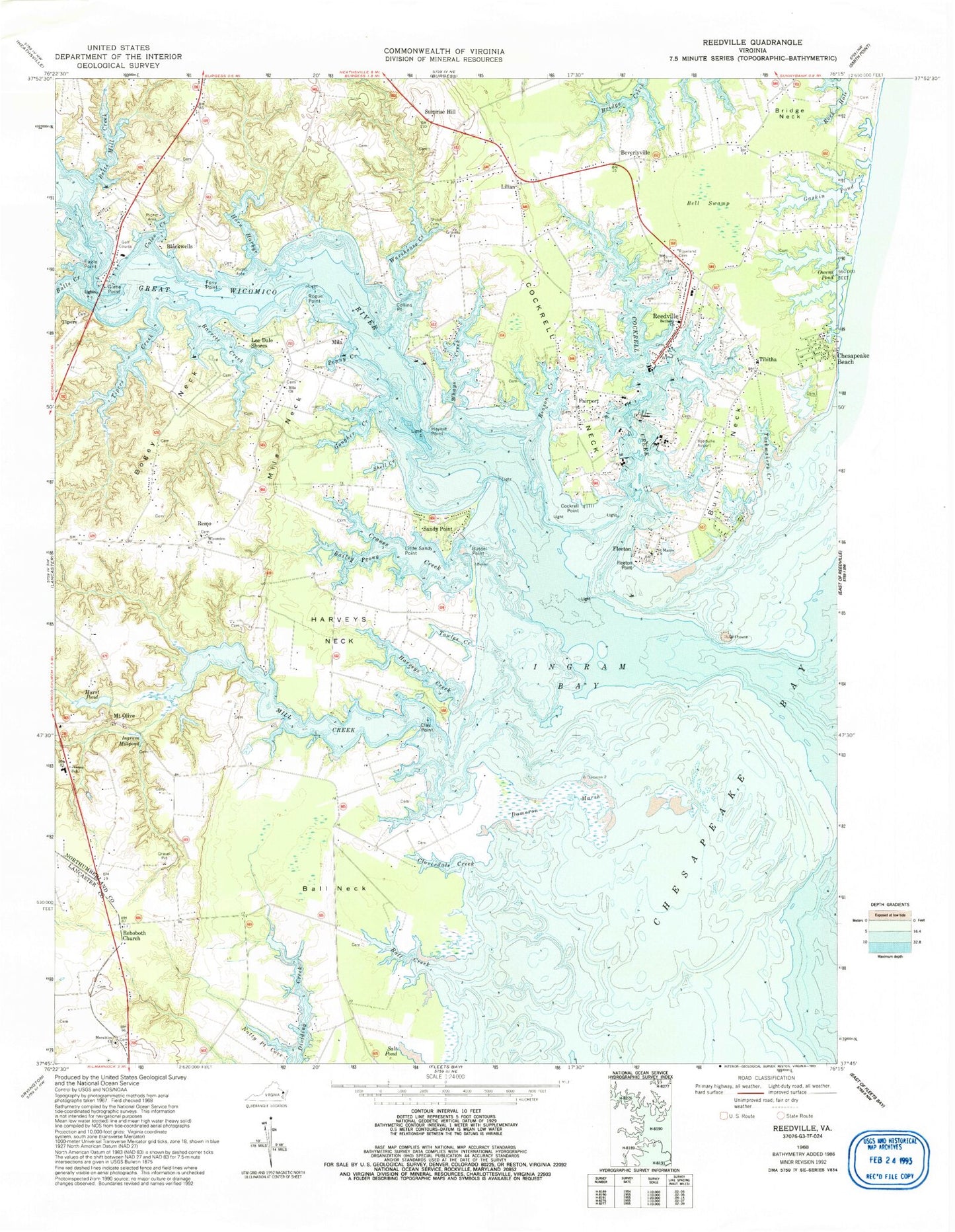
Classic USGS Reedville Virginia 7.5'x7.5' Topo Map
Couldn't load pickup availability
Historical USGS topographic quad map of Reedville in the state of Virginia. Typical map scale is 1:24,000, but may vary for certain years, if available. Print size: 24" x 27"
This quadrangle is in the following counties: Lancaster, Northumberland.
The map contains contour lines, roads, rivers, towns, and lakes. Printed on high-quality waterproof paper with UV fade-resistant inks, and shipped rolled.
Contains the following named places: Bailey Prong, Ball Creek, Ball Neck, Balls Creek, Barrett Creek, Bell Swamp, Bethany Church, Betts Mill Creek, Bogey Neck, Bull Neck, Bussel Point, Clay Point, Cloverdale Creek, Cockrell Creek, Cockrell Neck, Cockrell Point, Coles Creek, Collins Point, Cranes Creek, Dameron Marsh, Eagle Point, Ferry Point, Gaskin Pond, Glebe Point, Gougher Creek, Great Wicomico River, Harveys Creek, Harveys Neck, Haynie Point, Horn Harbor, Hurst Pond, Ingram Bay, Ingram Millpond, Jeanes School, Little Sandy Point, Mila Church, Mila Neck, Mill Creek, Morattico Church, Natty Point Cove, Owens Pond, Penny Creek, Reason Creek, Rehoboth Church, Rogue Point, Roseland Cemetery, Saint Marys Church, Salt Pond, Shell Creek, Hope Union Cemetery, Taskmakers Creek, Tibitha, Tipers Creek, Towles Creek, Warehouse Creek, Whays Creek, Wicomico Church, Mount Olive, Remo, Waddeys, Tim Point, Remo Private Airport, Hurst Dam, Apple Grove Airport (historical), Reedville Airport, Beverlyville, Blackwells, Chesapeake Beach, Fairport, Fleeton, Lee Dale Shores, Lilian, Mila, Reedville, Sandy Point, Surprise Hill, Tipers, Fleeton Point, Blackberry, Bridge Neck School (historical), Carlson Store (historical), Delanos Store (historical), Fleet Point Light, Fleeton Bay, Fleeton Beach, Gascony Cove, Glebe Point Landing, Goffs Bar, Harveys Point, Hughletts Neck, Ingrams Mill (historical), Julius Rosenwald School (historical), Kings Head, Liberty Methodist Protestant Church (historical), Mila School (historical), Mount Olive Church, Reeds Point, Reedville High School (historical), Reedville Historic District, Rehoboth United Methodist Church, Shiloh Church (historical), Shiloh School (historical), Tibitha Church of God, Tipers Bridge, Morattico Cemetery, District 4, District 5, Fairfields Volunteer Fire Department, Fairfields Volunteer Fire Department - Glebe Point Fire House, Northumberland County Rescue Squad, Smith Point Sea Rescue 1, Northumberland Volunteer Rescue Squad Station 1, Lighthouse Christian Academy, Buzzard's Point Marina, Fairport Marina, Ingram Bay Marina, Reedville Post Office