MyTopo
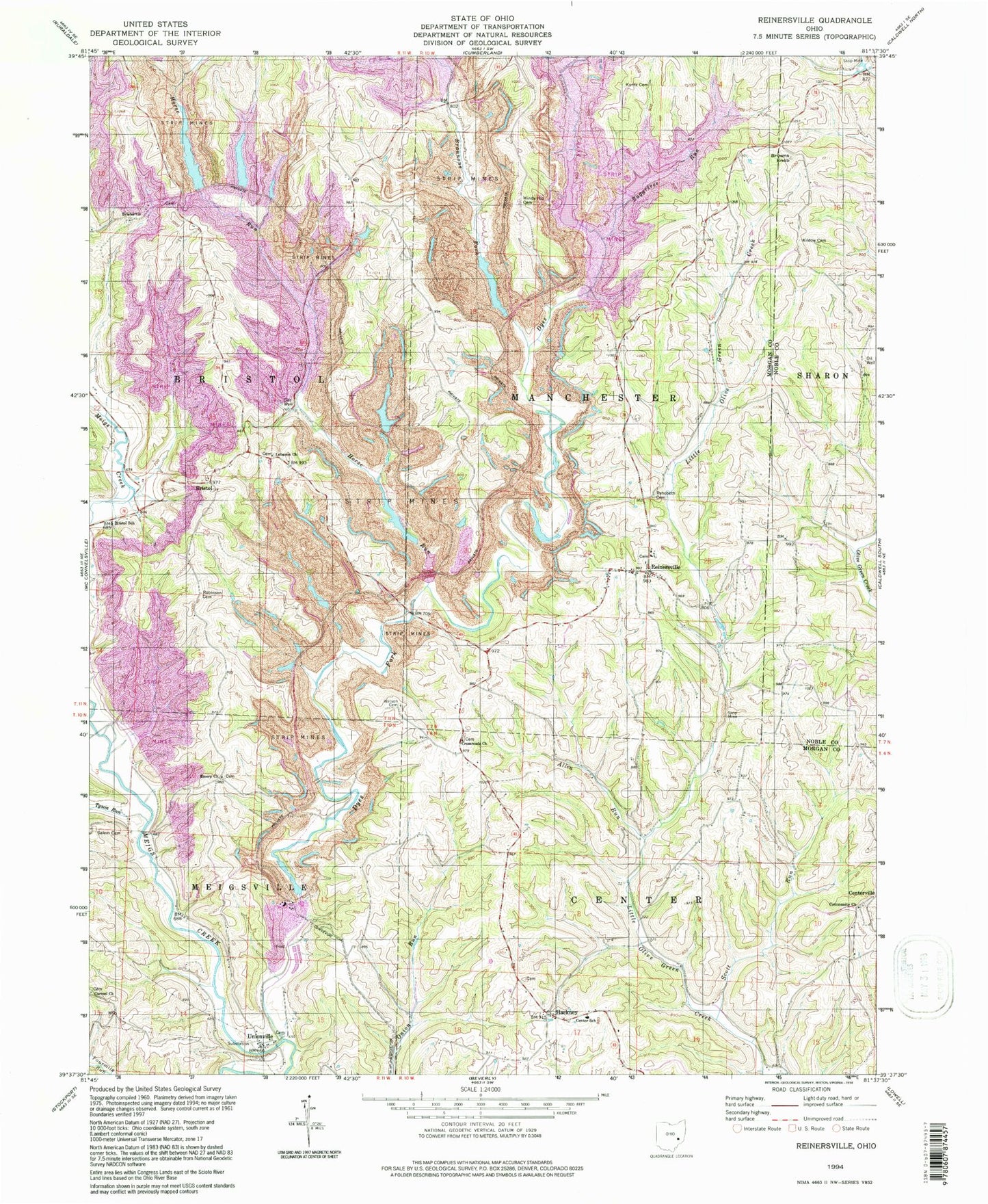
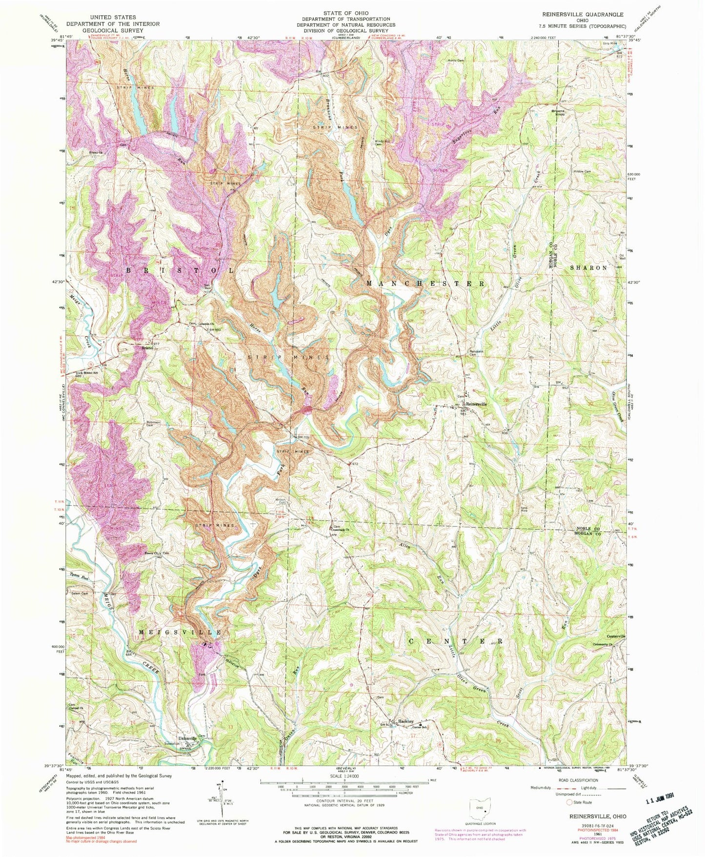
Classic USGS Reinersville Ohio 7.5'x7.5' Topo Map
Couldn't load pickup availability
Historical USGS topographic quad map of Reinersville in the state of Ohio. Typical map scale is 1:24,000, but may vary for certain years, if available. Print size: 24" x 27"
This quadrangle is in the following counties: Morgan, Noble.
The map contains contour lines, roads, rivers, towns, and lakes. Printed on high-quality waterproof paper with UV fade-resistant inks, and shipped rolled.
Contains the following named places: Allen Run, Center School, Dyes Fork, Horse Run, Kildow Cemetery, Kuntz Cemetery, Rehobeth Cemetery, Robinson Cemetery, Salem Cemetery, Scott Run, Sugartree Run, Tyson Run, Watson Cemetery, Windy Hill Cemetery, Browns Knob, Walters School (historical), Valley School (historical), Sand Hill School (historical), Pleasant Hill School (historical), Fairview School (historical), Bald Knob School (historical), Otho (historical), Windy Hill School (historical), Bethel Church (historical), Oak Grove School (historical), Foster School (historical), Seeleyburg (historical), Unionville, Brannons Fork, Brill (historical), Cabinville (historical), Centerville Cemetery, Centerville Community Church, Crossroads Cemetery, Mount Carmel Cemetery, Reinersville Cemetery, Reinersville Methodist Church, Reinersville School (historical), Saint Margaret Cemetery, Unionville Cemetery, Bristol, Bristol Presbyterian Church, Crossroads Church, Emery Church, Hackney, Lebanon United Methodist Church, Reinersville, Cabin Vale School (historical), Ohio Power Company Dam 9515-001, Ohio Power Company Pond 9515-001, Ohio Power Company Dam 9515-002, Ohio Power Company Pond 9515-002, Ohio Power Company Dam 9515-004, Ohio Power Company Pond 9515-004, Ohio Power Company Pond Mm-29 Dam, Ohio Power Company Pond Mm-29, Ohio Power Company Dam 9515-011, Ohio Power Company Pond 9515-011, Ohio Power Company Pond Number 9515-012 Dam, Ohio Power Company Pond Number 9515-012, Ohio Power Company Pond 9515-013 Dam, Ohio Power Company Pond 9515-013, Ohio Power Company Pond 9515-018 Dam, Ohio Power Company Pond 9515-018, Ohio Power Company Pond 9515-019 Dam, Ohio Power Company Pond 9515-019, Ohio Power Company Pond Mb-166 Dam, Ohio Power Company Pond Mb-166, Ohio Power Company Pond 9515-021 Dam, Ohio Power Company Pond 9515-021, Ohio Power Company Pond Mmv-9 Dam, Ohio Power Company Pond Mmv-9, Ohio Power Company Pond Number 9515-015, Ohio Power Company Pond Mm-34 Dam, Ohio Power Company Pond Mm-34, Ohio Power Company Pond Mm-52 Dam, Ohio Power Company Pond Mm-52, Ohio Power Company Pond Mb-165 Dam, Ohio Power Company Pond Mb-165, Ohio Power Company Pond Number 9515-025 Dam, Ohio Power Company Pond Number 9515-025, Ohio Power Company Pond Mmv-5 Dam, Ohio Power Company Pond Mmv-5, Ohio Power Company Pond Mm-49 Dam, Ohio Power Company Pond Mm-49, Ohio Power Company Pond Mm-85, Bristol Elementary School, Township of Center, Township of Manchester, Barr Cemetery, Bristol Cemetery, Emery Cemetery, Lebanon Cemetery, Brill Post Office (historical), Bristol Post Office (historical), Hackney Post Office (historical), Otho Post Office (historical), Reinersville Post Office, Reinersville Volunteer Fire Department