MyTopo
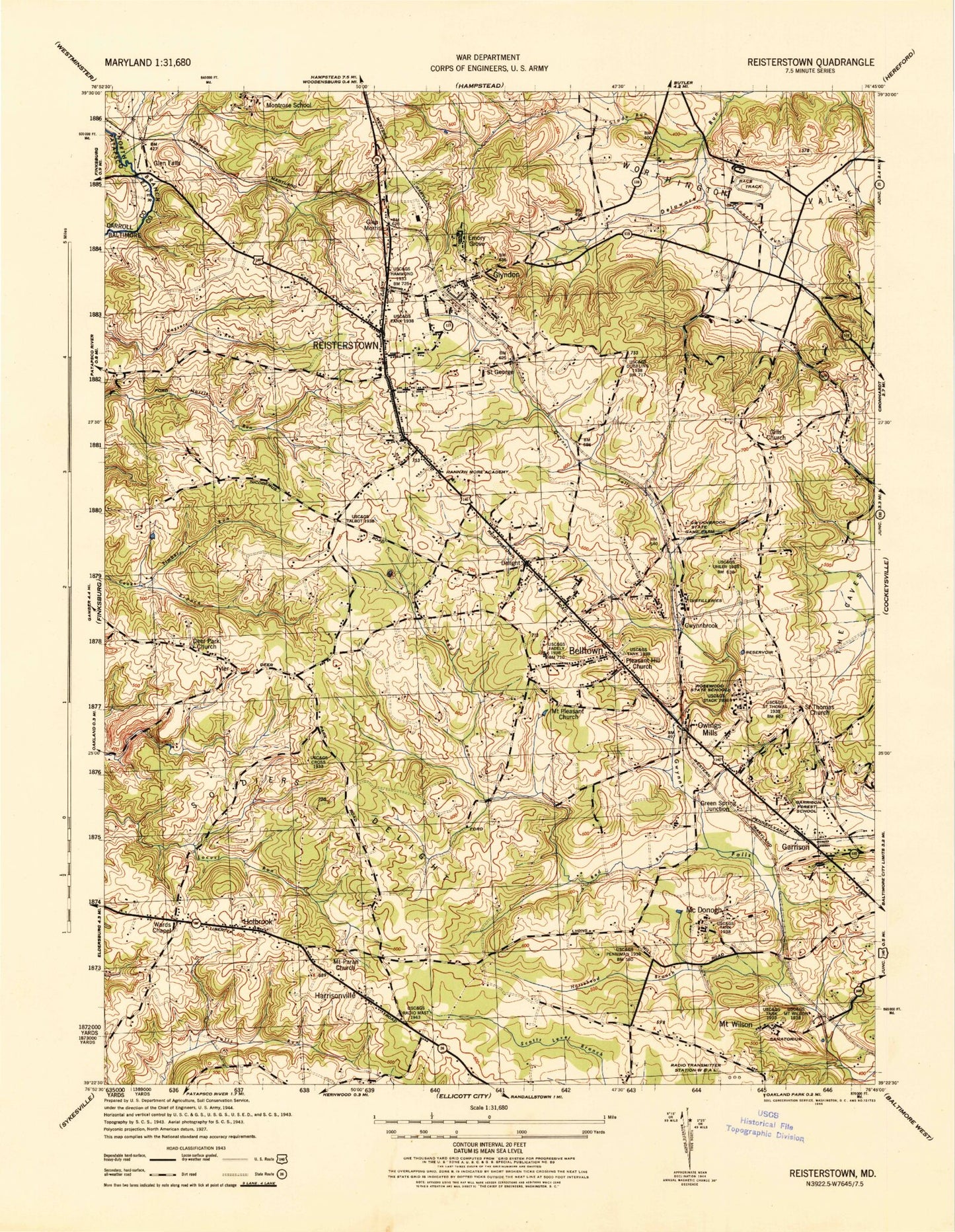
Classic USGS Reisterstown Maryland 7.5'x7.5' Topo Map
Couldn't load pickup availability
Historical USGS topographic quad map of Reisterstown in the state of Maryland. Typical map scale is 1:24,000, but may vary for certain years, if available. Print size: 24" x 27"
This quadrangle is in the following counties: Baltimore, Carroll.
The map contains contour lines, roads, rivers, towns, and lakes. Printed on high-quality waterproof paper with UV fade-resistant inks, and shipped rolled.
Contains the following named places: Chevra Ahavas Chesed Cemetery, Chimney Branch, Councilmans Run, Deer Park Church, Franklin Middle School, Garrison Forest School for Girls, Gills Church, Gwynnbrook State Game Farm, Hannah More Academy for Girls, Horsehead Branch, McDonogh School for Boys, Montrose School for Girls, Mount Paran Church, Mount Pleasant Church, Owings Mills, Owings Mills Elementary School, Pleasant Hill Church, Red Run, Richleigh School, Rosewood State Training School, Sacred Heart Church, Saint Georges, Saint Lukes Cemetery, Saint Thomas Cemetery, Saint Thomas Church, Slade Run, Soldiers Delight, The Caves, Beth El Memorial Park, Timber Run, Wards Chapel, Worthington Valley, Belltown, Deer Park, Delight, Emory Grove, Garrison, Glen Falls, Glen Morris, Glyndon, Green Spring Junction, Gwynnbrook, Harrisonville, Holbrook, McDonogh, Mount Wilson, Reisterstown, Tyler, Worthington, Green Spring Golf Course, Green Spring Valley Hunt Club, Arborwood, Camp Glyndon, Cedarmere Elementary School, Chartley, Chartley Shopping Center, Chatsworth School, Community Church, Crandon, Deer Cross, Deer Park Elementary School, Deer Park Middle School, Deer Park Plaza Shopping Center, Delight Meadows, Evergreen Church, Falcon Ridge, Foxridge, Franklin Elementary School, Franklin High School, Franklin Valley, Glen Falls Station (historical), Glyndon Elementary School, Glyndon Greens, Green Hill Farm, Hannah More Park, Lyons Mill Elementary School, Hernwood Heights, Hickory Hill Estates, Hunters Glen South, Imperial Gardens, Ivy Meadows, Julian Woods, Laurel Hill Country Club, Lyonswood, Marriott Plaza Shopping Center, McDonogh Manor, McDonogh Park, Nob Hill, Norris Run Woods, Oheb Shalom Memorial Park, Olde Mill Estates, Randallstown High School, Reisterstown Elementary School, Reisterstown Public Library, Reisterstown Shopping Center, Reisterstown Village Shopping Center, Reservoir Ridge, Rolling Ridge, Sagamore Forest, Sagamore Village, Silverbrook Farm, Stoneybrook North, Soldiers Delight Natural Environmental Area, Suburbia, Sunnybrook Farms, Taggert Memorial Chapel, The Chase at Foxridge, The Manors, The Meadows, Timber Chase, Timber Grove, Timber Grove Elementary School, Tree Top Station, Twelve Trees, Village of Timber Grove, Whispering Meadows, Wildwood Park, Wildwoods, Winands Valley Estates, Woodglen Farms, Woodlands, Woodleaf, Worthington Meadows, Ruxton Country School, Academy Acres, Academy Lane, Allyson Gardens, Cave Valley, Cedarmere, Cherry Vale Plaza Shopping Center, Cherry Valley, Dunbar, Fox Haven Estates, Garrison Forest, Garrison Forest Plaza Shopping Center, Garrison Post Office, Garrison Ridge, Green Spring Valley Country Club, Gunrich (historical), Har Sinai Congregation Cemetery, Hathaway, Hewitt Farms, Hunters Glen, Kendig Mill Station, Garrison Forest Veterans Cemetery, Morningside Heights, Owings Mills Commerce Center, Owings Mills Corporate Center, Owings Mills High School, Owings Mills Industrial Park, Owings Mills Library, Owings Mills Post Office, Owings Mills Town Center Shopping Center, Owings Ridge, Pleasant Hill, Reisterstown Baptist Church, Roaches Run Park, Saint Thomas Shopping Center, Sarawoods, Tobin, Tollgate, Valley Hills, Valleys Crest Farm, Velvet Hills, Velvet Hills South, Village of Painters Mill, Westbury, Worthington Glen, Worthington Park, Worthington Place South, Worthington Run, Glyndon Post Office, Reisterstown Post Office, Mount Wilson State Hospital, Rosewood State Hospital, WBAL-AM (Baltimore), WCBM-AM (Baltimore), WCAO-AM (Baltimore), WMPB-TV (Baltimore), District 4, Mount Wilson Post Office (historical), Emorygrove Post Office (historical), Baltimore County Fire Department Franklin - Station 56, Glyndon Volunteer Fire Department Station 40, Liberty Road Volunteer Fire Company Station 46, Owings Mills Volunteer Fire Company Station 31, Baltimore County Fire Department Garrison - Station 19, Reisterstown Volunteer Fire Company Station 41, Dundalk Fire Department Station 6, Baltimore County Police Department Precinct 3 - Franklin, Boulevard Corporate Center, Crondall Corner Shops Shopping Center, Kings Point Square Shopping Center, Reisterstown Business Center, Valley Center Shopping Center, Holy Family Elementary School, Saint Thomas Parish Cooperative Day School, Liberty Christian School, Kiddie Academy - Owings Mills, Torah Institute of Baltimore Elementary School, Sacred Heart Elementary School, Kingsway Academy, Randallstown Evening High School, Jewish Community Center, Hannah More School, Israel Henry Beren High School, The Joseph and Corinne Schwartz School, Beth El Aleph Bet Child Development Center, New Town Elementary School, New Town High School, A Small World, Reistertown Baptist Child Day Care, ITT Technical Institute - Owings Mills, Villa Julie College Owings Mills, Ner Israel Rabbinical College, The Harbour School Baltimore Campus, Baltimore County Police Department Precinct 3 - Franklin, Owings Mills Census Designated Place, Reisterstown Census Designated Place, Garrison Census Designated Place, Worthington Valley Airport, Deer Park Middle Magnet School, Chapel Hill Nursing Center, Future Care of Cherrywood Nursing Home, Northminster Presbyterian Church, Soldiers Delight Mine, Woodensburg Nursery and Greenhouses, Liberty Presbyterian Church, Maryland Natural Resources Police Central Region Gwynnbrook Office


