MyTopo
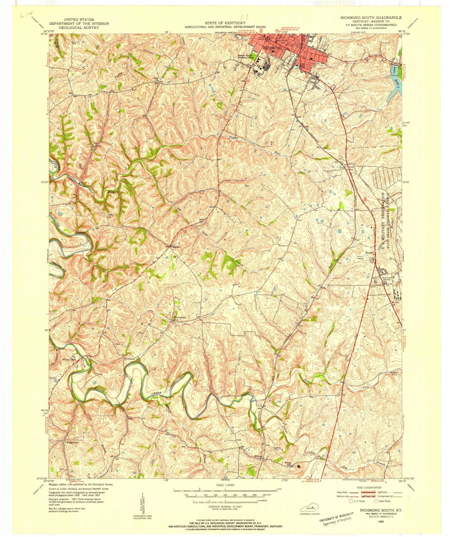
Classic USGS Richmond South Kentucky 7.5'x7.5' Topo Map
Couldn't load pickup availability
Historical USGS topographic quad map of Richmond South in the state of Kentucky. Typical map scale is 1:24,000, but may vary for certain years, if available. Print size: 24" x 27"
This quadrangle is in the following counties: Madison.
The map contains contour lines, roads, rivers, towns, and lakes. Printed on high-quality waterproof paper with UV fade-resistant inks, and shipped rolled.
Contains the following named places: Ballard Branch, Blue Grass Memorial Cemetery, Buggytown, Dog Branch, Eastern Kentucky University, Elk Garden Branch, Harts Fork, Jones Branch, Madison County Memorial Gardens, Madison School, Mayfield School, Mount Zion Christian Church, Old Town Branch, Pond Church, Lake Reba, Richmond, Taylor Fork, Wilgreen Lake, Terrill, Walker Branch, Whites Church, Caleast, Duncanon, Peytontown, Silver Creek, Whites, Hays Fork, Madison County, Berea-Richmond Airport (historical), Central Kentucky Regional Airport, WEKY-AM (Richmond), WCBR-AM (Richmond), WMCQ-FM (Richmond), Richmond Division, City of Richmond, Whites Post Office (historical), Whites Railroad Station (historical), Cochran Cemetery, Morans Mill (historical), Silver Creek Railroad Station (historical), Mound Creek, Silver Creek Post Office (historical), Silver Creek Presbyterian Church (historical), Silver Creek Bridge, Peytontown Railroad Station (historical), Peytontown Post Office (historical), Harris Flat Railroad Station (historical), Arcadia Post Office (historical), Terrill Post Office (historical), Caleast Post Office (historical), Hagans Mill (historical), Haines Cemetery, Twitties Fort Station (historical), Harris Post Office (historical), Estill Post Office (historical), Harris Railroad Station (historical), Blacks Branch, Bond Estill Spring (historical), Pumpkin Run, Gibson Bay Golf Course, Vaughn Branch, Fort Estill Junction (historical), Embry Hill, Madison County Fire Department Station 2, Richmond Fire Department Station 1, Richmond Fire Department Station 3, Richmond Fire Department Station 2, Baptist Health Hospital Richmond, Hancock Taylor Historical Marker, White Oak Pond Church Historical Marker, Madison County Historical Marker, Richmond Police Department, Madison County Sheriff's Office, Kentucky State Police Post 7, Richmond Post Office, Ballard Branch, Blue Grass Memorial Cemetery, Buggytown, Dog Branch, Eastern Kentucky University, Elk Garden Branch, Harts Fork, Jones Branch, Madison County Memorial Gardens, Madison School, Mayfield School, Mount Zion Christian Church, Old Town Branch, Pond Church, Lake Reba, Richmond, Taylor Fork, Wilgreen Lake, Terrill, Walker Branch, Whites Church, Caleast, Duncanon, Peytontown, Silver Creek, Whites, Hays Fork, Madison County, Berea-Richmond Airport (historical), Central Kentucky Regional Airport, WEKY-AM (Richmond), WCBR-AM (Richmond), WMCQ-FM (Richmond), Richmond Division, City of Richmond, Whites Post Office (historical), Whites Railroad Station (historical), Cochran Cemetery, Morans Mill (historical), Silver Creek Railroad Station (historical), Mound Creek, Silver Creek Post Office (historical), Silver Creek Presbyterian Church (historical), Silver Creek Bridge, Peytontown Railroad Station (historical), Peytontown Post Office (historical), Harris Flat Railroad Station (historical), Arcadia Post Office (historical), Terrill Post Office (historical), Caleast Post Office (historical), Hagans Mill (historical), Haines Cemetery, Twitties Fort Station (historical), Harris Post Office (historical), Estill Post Office (historical), Harris Railroad Station (historical), Blacks Branch, Bond Estill Spring (historical), Pumpkin Run, Gibson Bay Golf Course, Vaughn Branch, Fort Estill Junction (historical), Embry Hill, Madison County Fire Department Station 2, Richmond Fire Department Station 1, Richmond Fire Department Station 3, Richmond Fire Department Station 2, Baptist Health Hospital Richmond, Hancock Taylor Historical Marker, White Oak Pond Church Historical Marker, Madison County Historical Marker, Richmond Police Department, Madison County Sheriff's Office, Kentucky State Police Post 7, Richmond Post Office