


MyTopo
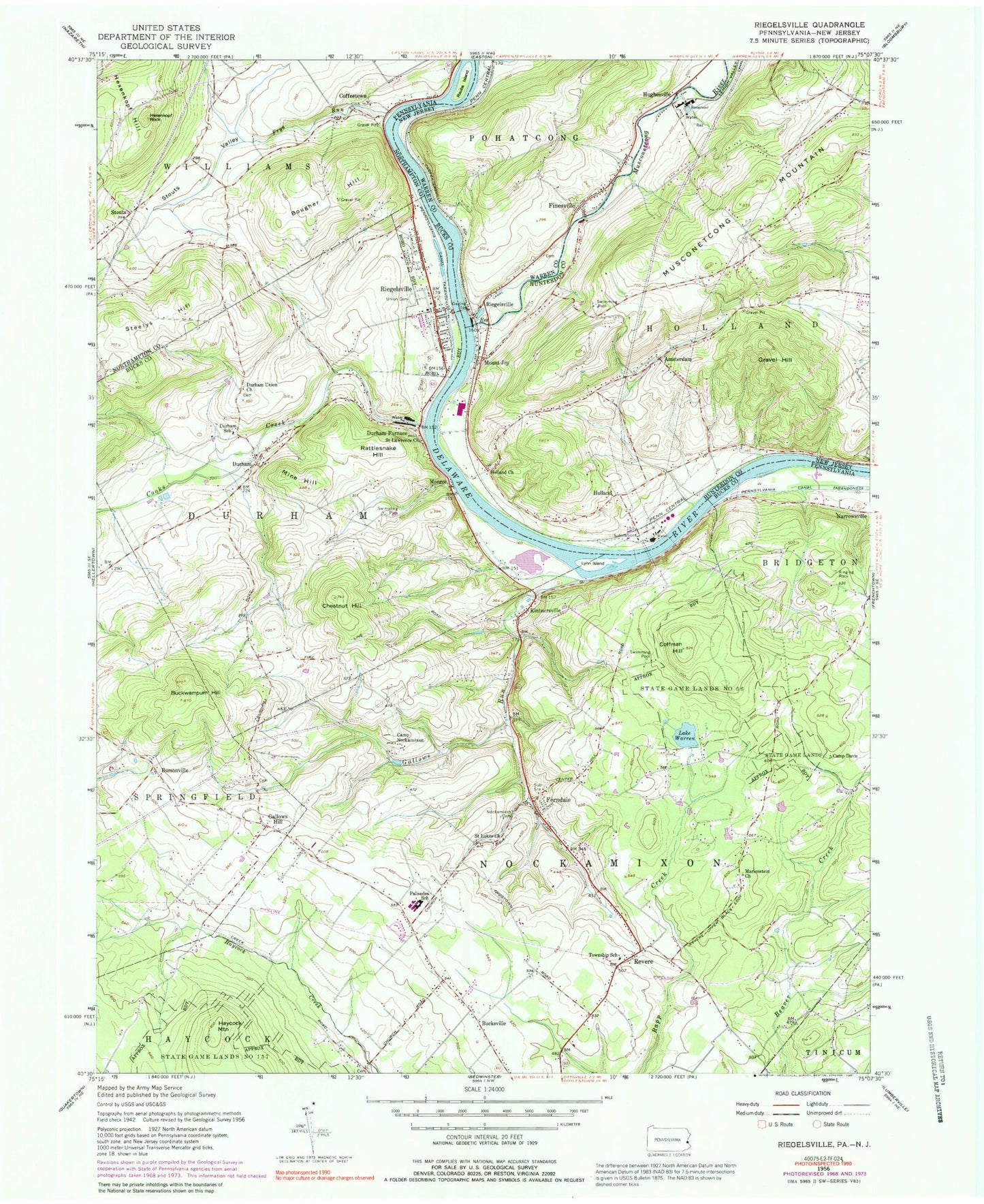
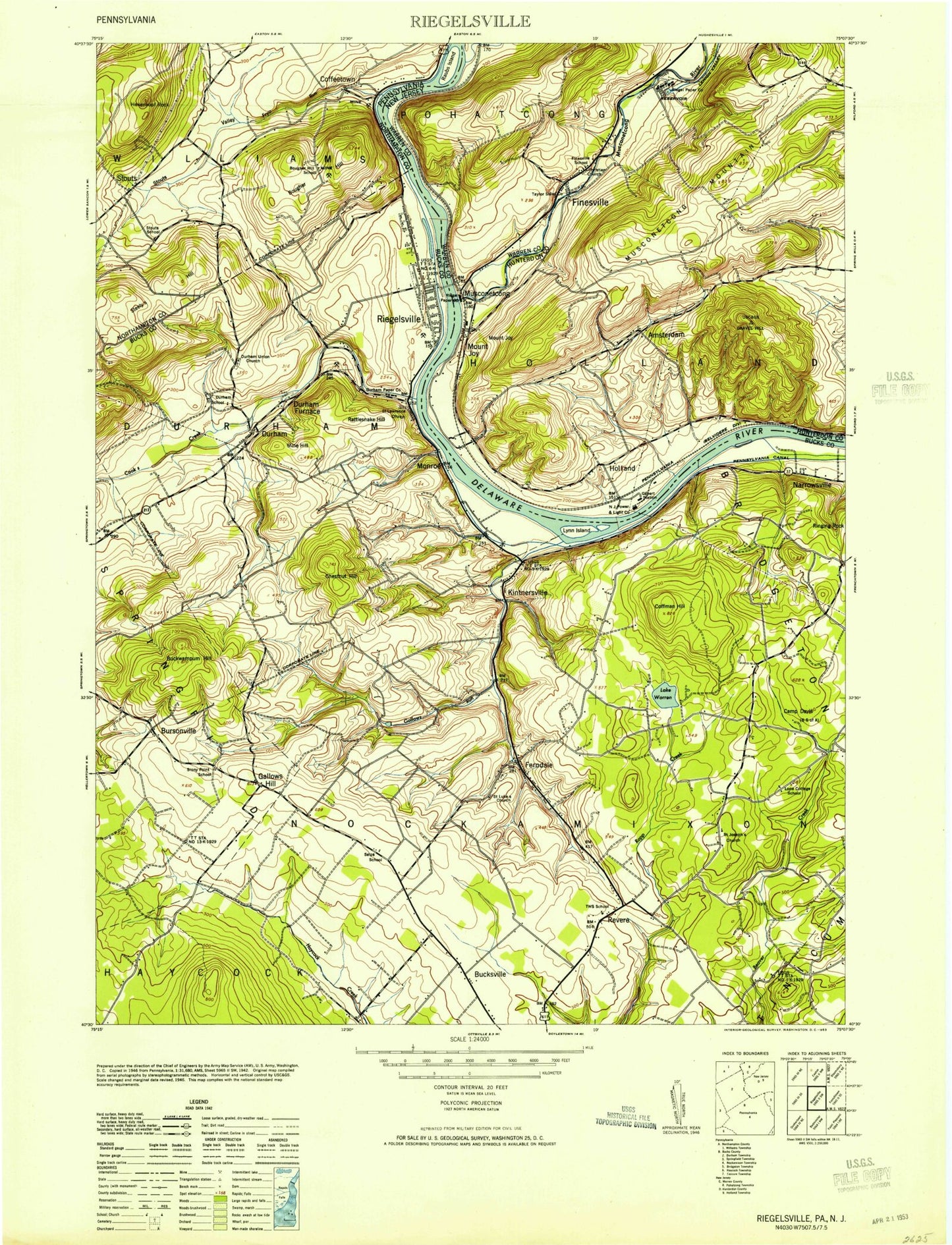
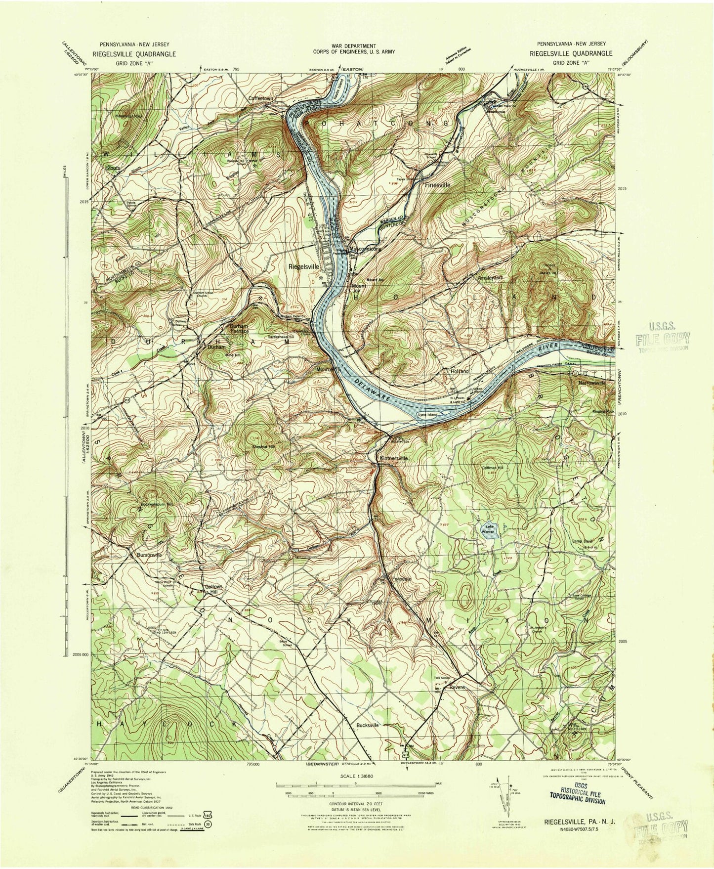
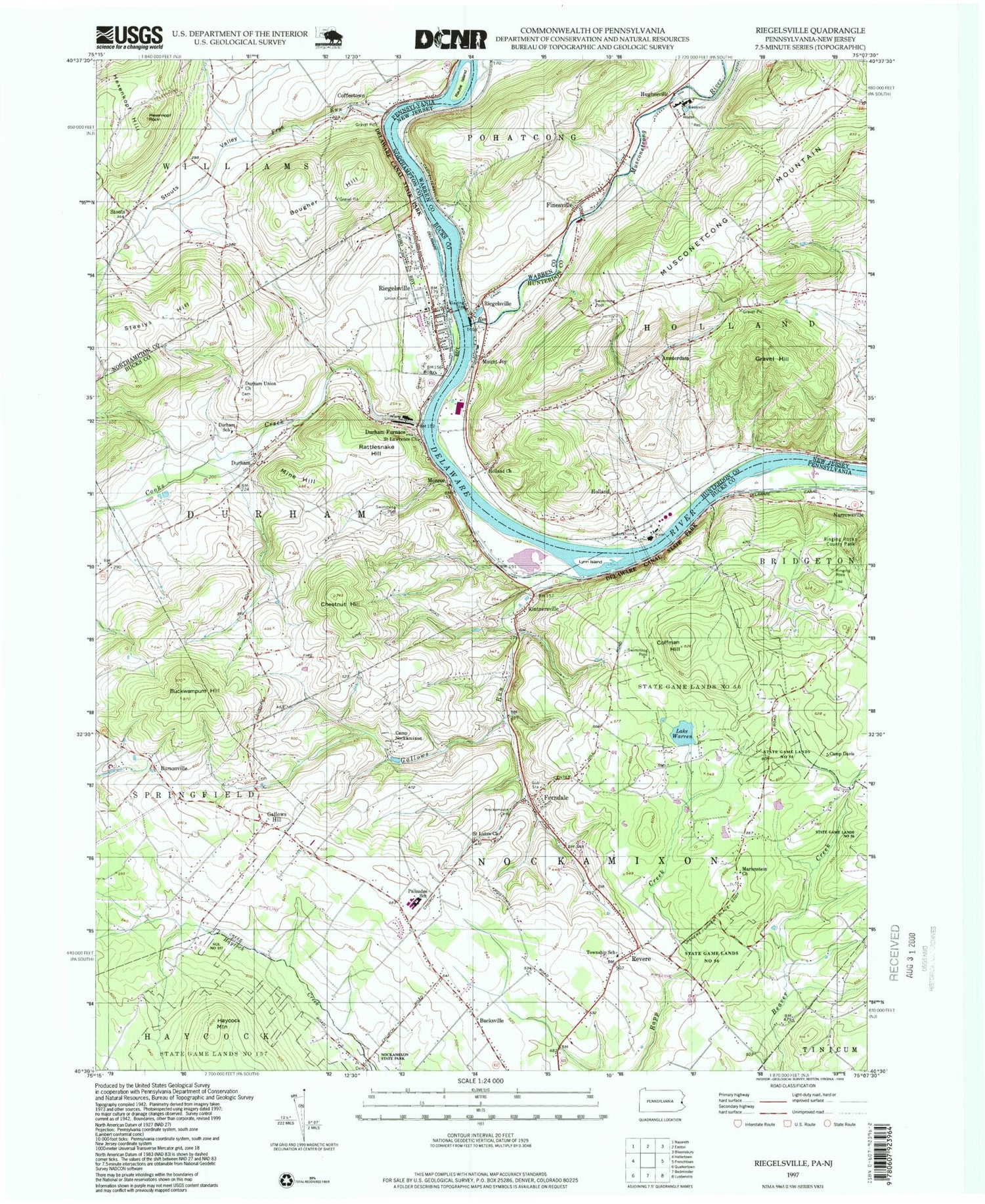
Classic USGS Riegelsville Pennsylvania 7.5'x7.5' Topo Map
Couldn't load pickup availability
Historical USGS topographic quad map of Riegelsville in the states of Pennsylvania, New Jersey. Typical map scale is 1:24,000, but may vary for certain years, if available. Print size: 24" x 27"
This quadrangle is in the following counties: Bucks, Hunterdon, Northampton, Warren.
The map contains contour lines, roads, rivers, towns, and lakes. Printed on high-quality waterproof paper with UV fade-resistant inks, and shipped rolled.
Contains the following named places: Bougher Hill, Buckwampum Hill, Bursonville, Camp Davis, Camp Nockamixon, Chestnut Hill, Coffeetown, Coffman Hill, Cooks Creek, Durham, Durham Furnace, Durham Union Church, Durham Union School, Ferndale, Frys Run, Gallows Hill, Gallows Run, Haupts Mill Bridge, Hexenkopf Hill, Hexenkopf Rock, Kintnersville, Lynn Island, Mine Hill, Nockamixon Union Cemetery, Rattlesnake Hill, Raubs Island, Revere, Riegelsville, Ringing Rock, Saint Lukes Church, State Game Lands Number 56, Steelys Hill, Stouts, Stouts Valley, Riegelsville Union Cemetery, Lake Warren, Haycock Brigade Field (historical), Lake Warren Dam, Bougher Hill School, Stouts School, Durham Paper Company Dam, Pleasant Valley, Durham Ferry (historical), Durham Hill Farms, Hollow Run, Stony Point School, Seips School, Trauger School, Bucksville Manor, Rolling Hill Acres, Lone Cottage School, Yocum Estates, Ringing Rocks County Park, Saint Johns United Church of Christ, Falls Creek, Bucksville, Monroe, Narrowsville, Nockamixon Cliffs, Haycock Creek, Palisades Junior-Senior High School, Durham-Nockamixon Elementary School, Rodges Run, Bucksville Post Office (historical), Durham Post Office (historical), Ferndale Post Office (historical), Bursonville Post Office (historical), Riegelsville Post Office (historical), Revere Post Office (historical), Borough of Riegelsville, Township of Durham, Township of Nockamixon, Saint Josephs Church, Riegelsville Community Fire Company Station 42, Upper Bucks Regional Emergency Medical Services Station 142, Rick's Egg Farm, Durham Cemetery, Gallows Hill Graveyard, Saint Lukes Evangelical Lutheran Church Cemetery, Durham Post Office, Ferndale Post Office, Riegelsville Post Office, Kintnersville Post Office, Revere Post Office, Amsterdam, Finesville, Gravel Hill, Holland, Holland Church, Hughesville, Mount Joy, Musconetcong River, Pohatcong Creek, Riegelsville, Finesville Dam, Finesville Census Designated Place, Holland Township Volunteer Fire Company Station 2, Holland Township Police Department, Bougher Hill, Buckwampum Hill, Bursonville, Camp Davis, Camp Nockamixon, Chestnut Hill, Coffeetown, Coffman Hill, Cooks Creek, Durham, Durham Furnace, Durham Union Church, Durham Union School, Ferndale, Frys Run, Gallows Hill, Gallows Run, Haupts Mill Bridge, Hexenkopf Hill, Hexenkopf Rock, Kintnersville, Lynn Island, Mine Hill, Nockamixon Union Cemetery, Rattlesnake Hill, Raubs Island, Revere, Riegelsville, Ringing Rock, Saint Lukes Church, State Game Lands Number 56, Steelys Hill, Stouts, Stouts Valley, Riegelsville Union Cemetery, Lake Warren, Haycock Brigade Field (historical), Lake Warren Dam, Bougher Hill School, Stouts School, Durham Paper Company Dam, Pleasant Valley, Durham Ferry (historical), Durham Hill Farms, Hollow Run, Stony Point School, Seips School, Trauger School, Bucksville Manor, Rolling Hill Acres, Lone Cottage School, Yocum Estates, Ringing Rocks County Park, Saint Johns United Church of Christ, Falls Creek, Bucksville, Monroe, Narrowsville, Nockamixon Cliffs, Haycock Creek, Palisades Junior-Senior High School, Durham-Nockamixon Elementary School, Rodges Run, Bucksville Post Office (historical), Durham Post Office (historical), Ferndale Post Office (historical), Bursonville Post Office (historical), Riegelsville Post Office (historical), Revere Post Office (historical), Borough of Riegelsville, Township of Durham, Township of Nockamixon, Saint Josephs Church, Riegelsville Community Fire Company Station 42, Upper Bucks Regional Emergency Medical Services Station 142, Rick's Egg Farm, Durham Cemetery, Gallows Hill Graveyard, Saint Lukes Evangelical Lutheran Church Cemetery, Durham Post Office, Ferndale Post Office, Riegelsville Post Office, Kintnersville Post Office, Revere Post Office, Amsterdam, Finesville, Gravel Hill, Holland, Holland Church, Hughesville, Mount Joy, Musconetcong River, Pohatcong Creek, Riegelsville, Finesville Dam, Finesville Census Designated Place, Holland Township Volunteer Fire Company Station 2, Holland Township Police Department, Bougher Hill, Buckwampum Hill, Bursonville, Camp Davis, Camp Nockamixon, Chestnut Hill, Coffeetown, Coffman Hill, Cooks Creek, Durham, Durham Furnace, Durham Union Church, Durham Union School, Ferndale, Frys Run, Gallows Hill, Gallows Run, Haupts Mill Bridge, Hexenkopf Hill, Hexenkopf Rock, Kintnersville, Lynn Island, Mine Hill, Nockamixon Union Cemetery, Rattlesnake Hill, Raubs Island, Revere, Riegelsville, Ringing Rock, Saint Lukes Church, State Game Lands Number 56, Steelys Hill, Stouts, Stouts Valley, Riegelsville Union Cemetery, Lake Warren, Haycock Brigade Field (historical), Lake Warren Dam, Bougher Hill School, Stouts School