
MyTopo
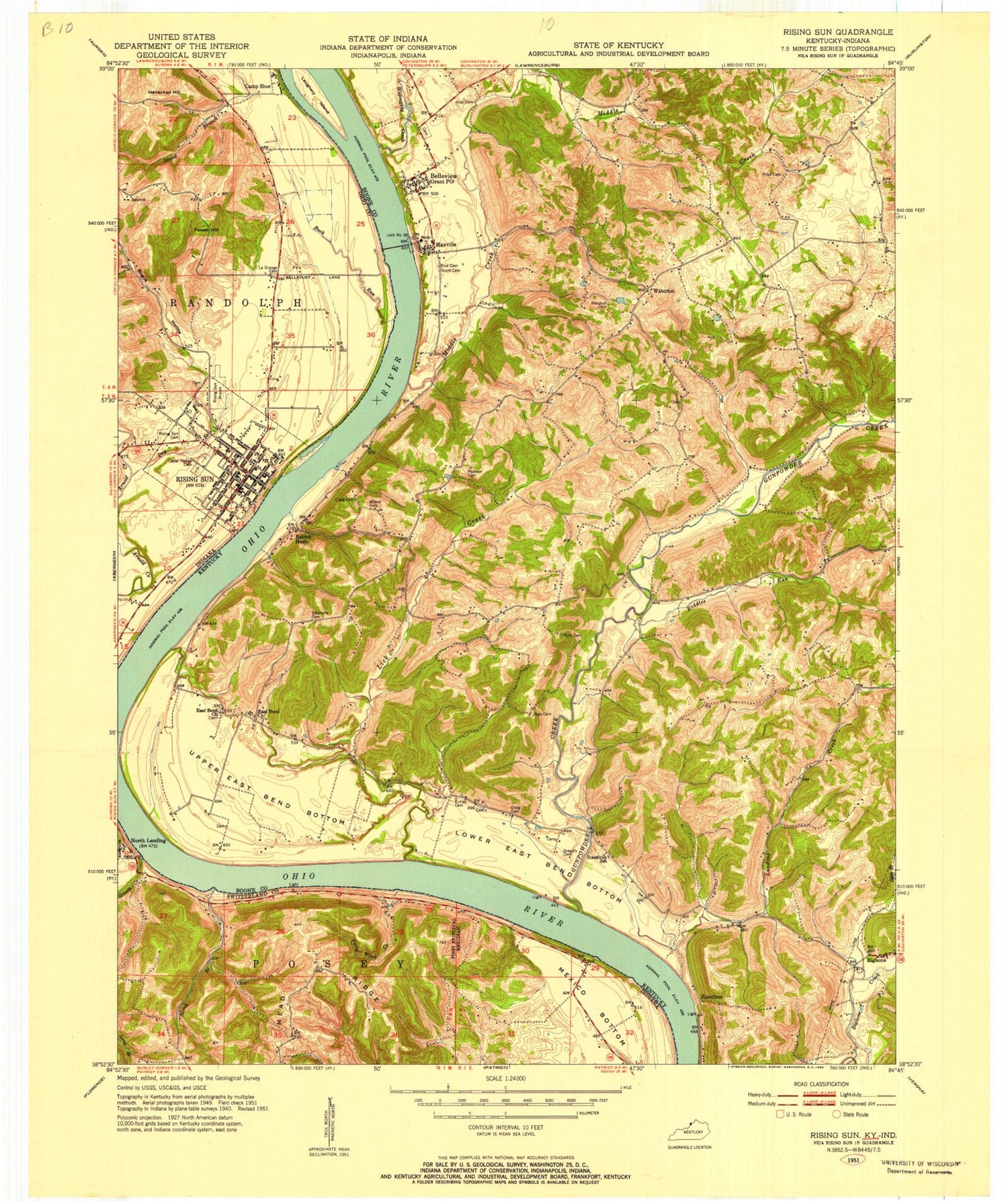
Classic USGS Rising Sun Indiana 7.5'x7.5' Topo Map
Couldn't load pickup availability
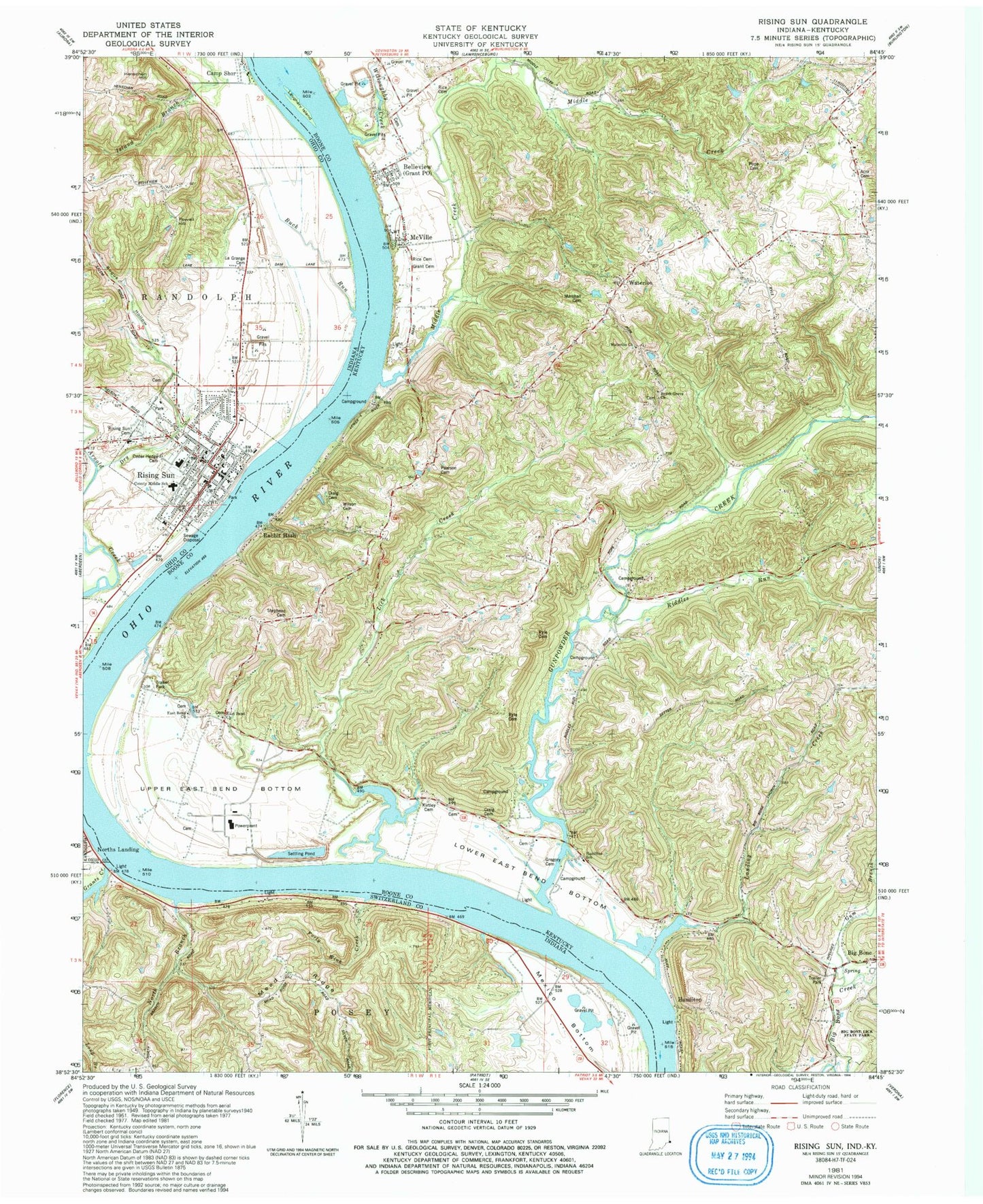
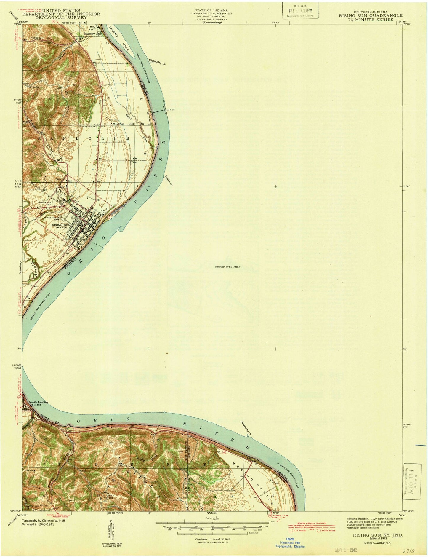
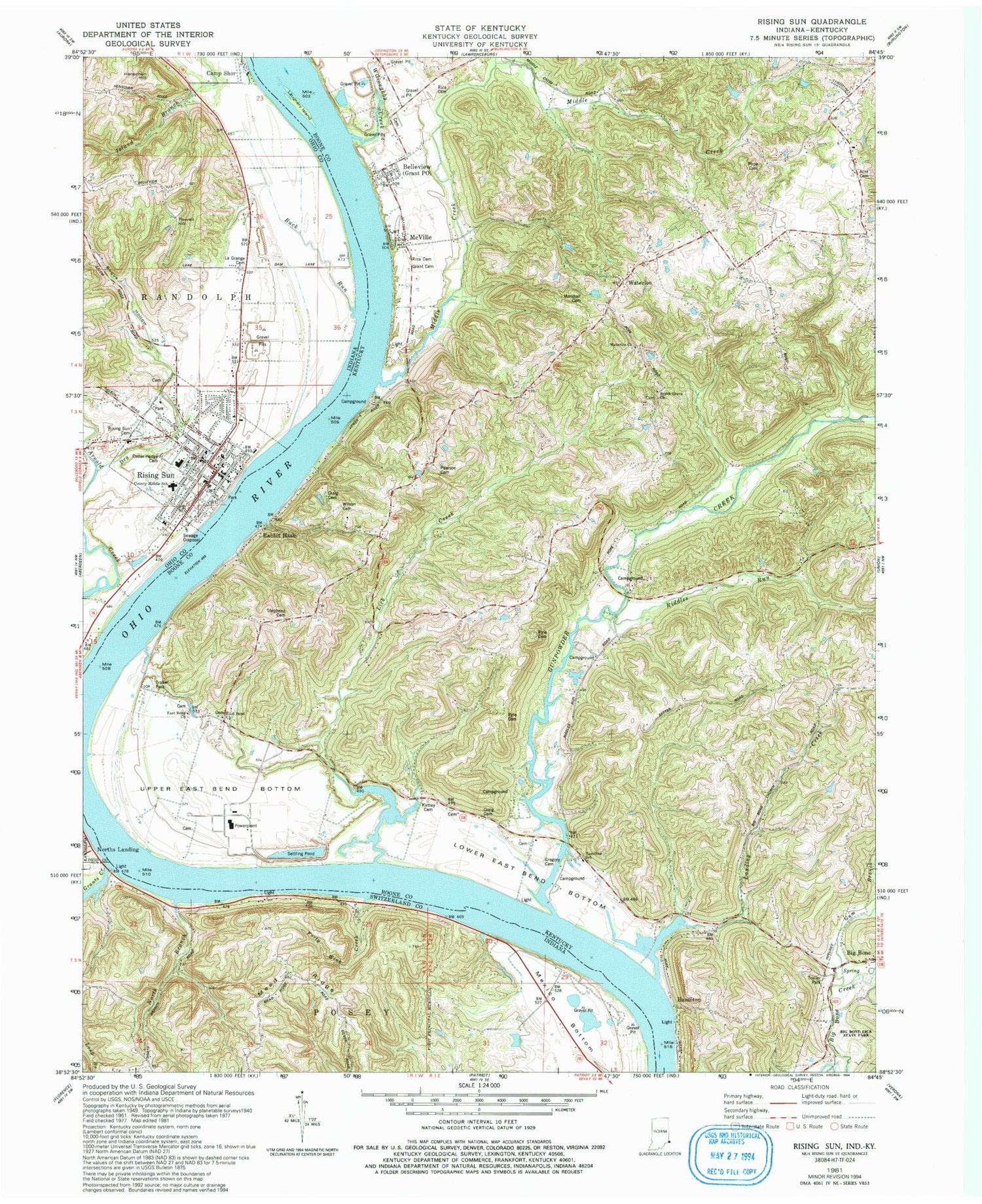
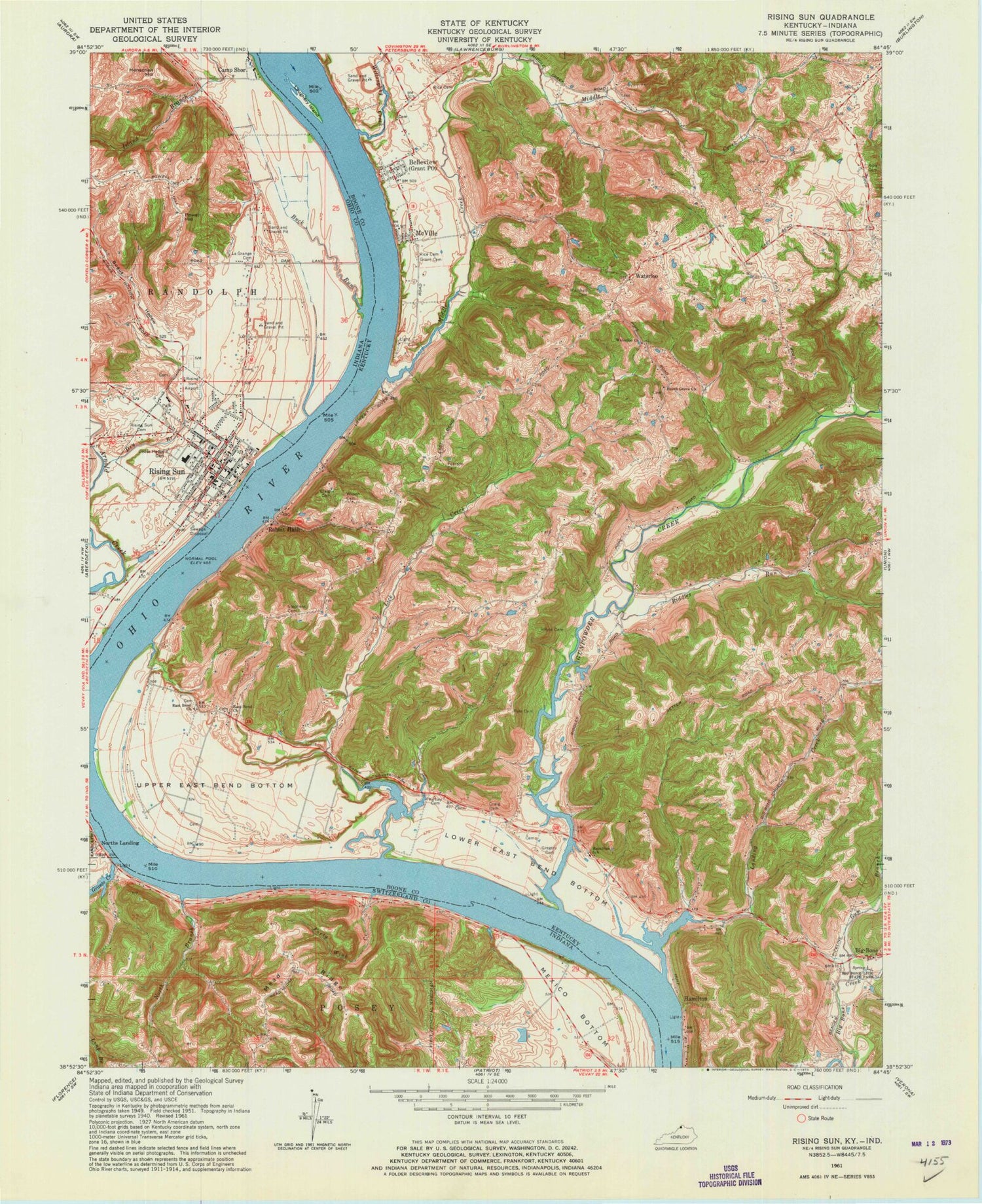
Historical USGS topographic quad map of Rising Sun in the states of Indiana, Kentucky. Typical map scale is 1:24,000, but may vary for certain years, if available. Print size: 24" x 27"
This quadrangle is in the following counties: Boone, Ohio, Switzerland.
The map contains contour lines, roads, rivers, towns, and lakes. Printed on high-quality waterproof paper with UV fade-resistant inks, and shipped rolled.
Contains the following named places: Bogus Hollow, Buck Run, Camp Shor, Cedar Hedge Cemetery, Dry Brook, Forty Wink Creek, Grants Creek, Henschen Hill, Fulton Burying Ground, Long Branch, Mexico Bottom, North Branch, Powell Hill, Rising Sun Cemetery, Ohio County Elementary-Middle School, Rising Sun, Norths Landing, City of Rising Sun, Rising Sun Volunteer Fire Department, Rising Sun Police Department, Ohio County Sheriff's Office, Rising Sun Post Office, Acra Cemetery, Beech Grove Church, Belleview, Big Bone, Big Bone Lick State Park, Black Cemetery, Craig Cemetery, Craig Cemetery, East Bend Church, East Bend Church, Grant Cemetery, Gregory Cemetery, Gum Branch, Gunpowder Creek, Hamilton School, Kirtley Cemetery, Landing Creek, Laughery Island, Lick Creek, Lower East Bend Bottom, Marshall Cemetery, McVille, Middle Creek, Pearson Cemetery, Pope Cemetery, Rabbit Hash, Rice Cemetery, Rice Cemetery, Riddles Run, Ryle Cemetery, Ryle Cemetery, Stephens Cemetery, Upper East Bend Bottom, Waterloo Church, Willoughby Creek, Wilson Cemetery, Hamilton, Waterloo, Burlington Division, Big Bone Lick, Beech Grove School (historical), Belleview Graded School (historical), Bigbone Post Office (historical), DeHart Creek, Grant Post Office (historical), Hamilton Mills (historical), Piatts Landing (historical), Roberts Mill (historical), School Number Nineteen (historical), Belleview Baptist Cemetery, Boones Post Office (historical), Dolph Landing (historical), East Bend Post Office (historical), Indian Hill, Locust Grove School (historical), Meeks Ferry Landing (historical), Piatts Landing Post Office (historical), Rabbit Hash Post Office (historical), Belleview Census Designated Place, Rabbit Hash Census Designated Place, Belleview - McVille Fire Protection District, Union Emergency Services Alliance Station 2, Boone County Water Rescue Fire Substation, Bogus Hollow, Buck Run, Camp Shor, Cedar Hedge Cemetery, Dry Brook, Forty Wink Creek, Grants Creek, Henschen Hill, Fulton Burying Ground, Long Branch, Mexico Bottom, North Branch, Powell Hill, Rising Sun Cemetery, Ohio County Elementary-Middle School, Rising Sun, Norths Landing, City of Rising Sun, Rising Sun Volunteer Fire Department, Rising Sun Police Department, Ohio County Sheriff's Office, Rising Sun Post Office, Acra Cemetery, Beech Grove Church, Belleview, Big Bone, Big Bone Lick State Park, Black Cemetery, Craig Cemetery, Craig Cemetery, East Bend Church, East Bend Church, Grant Cemetery, Gregory Cemetery, Gum Branch, Gunpowder Creek, Hamilton School, Kirtley Cemetery, Landing Creek, Laughery Island, Lick Creek, Lower East Bend Bottom, Marshall Cemetery, McVille, Middle Creek, Pearson Cemetery, Pope Cemetery, Rabbit Hash, Rice Cemetery, Rice Cemetery, Riddles Run, Ryle Cemetery, Ryle Cemetery, Stephens Cemetery, Upper East Bend Bottom, Waterloo Church, Willoughby Creek, Wilson Cemetery, Hamilton, Waterloo, Burlington Division, Big Bone Lick, Beech Grove School (historical), Belleview Graded School (historical), Bigbone Post Office (historical), DeHart Creek, Grant Post Office (historical), Hamilton Mills (historical), Piatts Landing (historical), Roberts Mill (historical), School Number Nineteen (historical), Belleview Baptist Cemetery, Boones Post Office (historical), Dolph Landing (historical), East Bend Post Office (historical), Indian Hill, Locust Grove School (historical), Meeks Ferry Landing (historical), Piatts Landing Post Office (historical), Rabbit Hash Post Office (historical), Belleview Census Designated Place, Rabbit Hash Census Designated Place, Belleview - McVille Fire Protection District, Union Emergency Services Alliance Station 2, Boone County Water Rescue Fire Substation, Bogus Hollow, Buck Run, Camp Shor, Cedar Hedge Cemetery, Dry Brook, Forty Wink Creek, Grants Creek, Henschen Hill, Fulton Burying Ground, Long Branch, Mexico Bottom, North Branch, Powell Hill, Rising Sun Cemetery, Ohio County Elementary-Middle School, Rising Sun, Norths Landing, City of Rising Sun, Rising Sun Volunteer Fire Department, Rising Sun Police Department, Ohio County Sheriff's Office, Rising Sun Post Office, Acra Cemetery, Beech Grove Church, Belleview, Big Bone, Big Bone Lick State Park, Black Cemetery, Craig Cemetery, Craig Cemetery, East Bend Church, East Bend Church, Grant Cemetery, Gregory Cemetery, Gum Branch, Gunpowder Creek, Hamilton School, Kirtley Cemetery, Landing Creek, Laughery Island, Lick Creek, Lower East Bend Bottom, Marshall Cemetery, McVille, Middle Creek, Pearson Cemetery, Pope Cemetery, Rabbit Hash, Rice Cemetery, Rice Cemetery, Riddles Run, Ryle Cemetery, Ryle Cemetery, Stephens Cemetery, Upper East Bend Bottom, Waterloo Church, Willoughby Creek, Wilson Cemetery, Hamilton, Waterloo, Burlington Division, Big Bone Lick, Beech Grove School (historical), Belleview Graded School (historical), Bigbone Post Office (historical), DeHart Creek