MyTopo
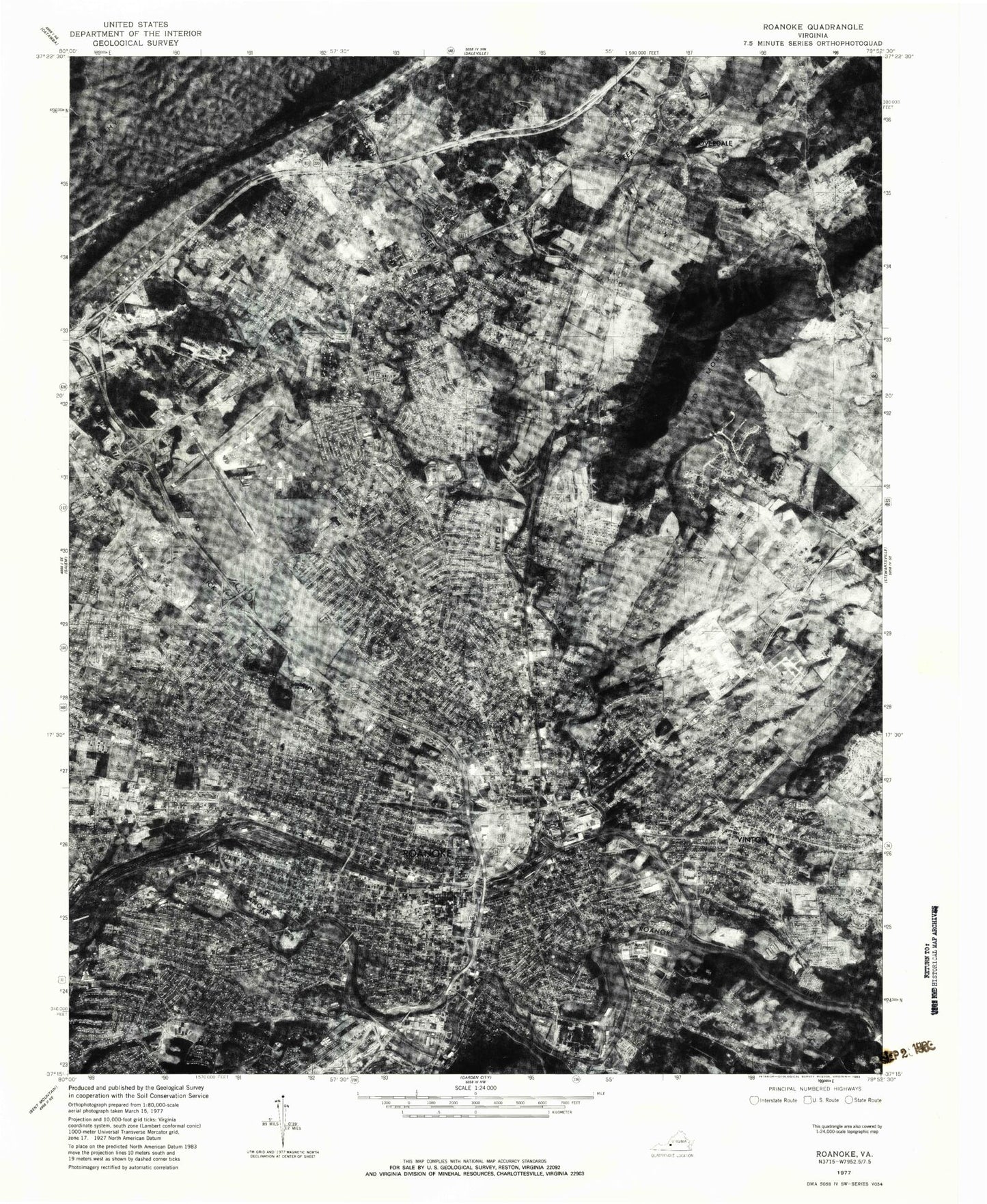
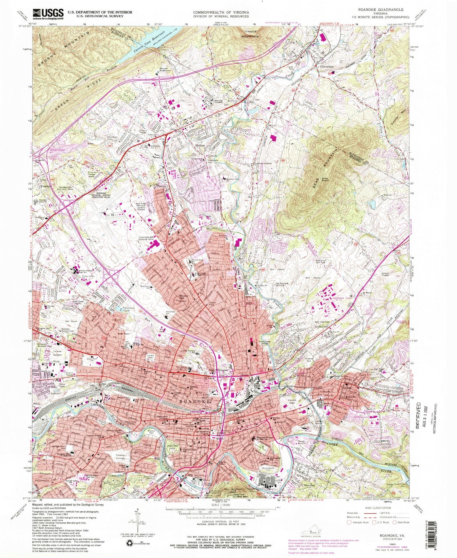
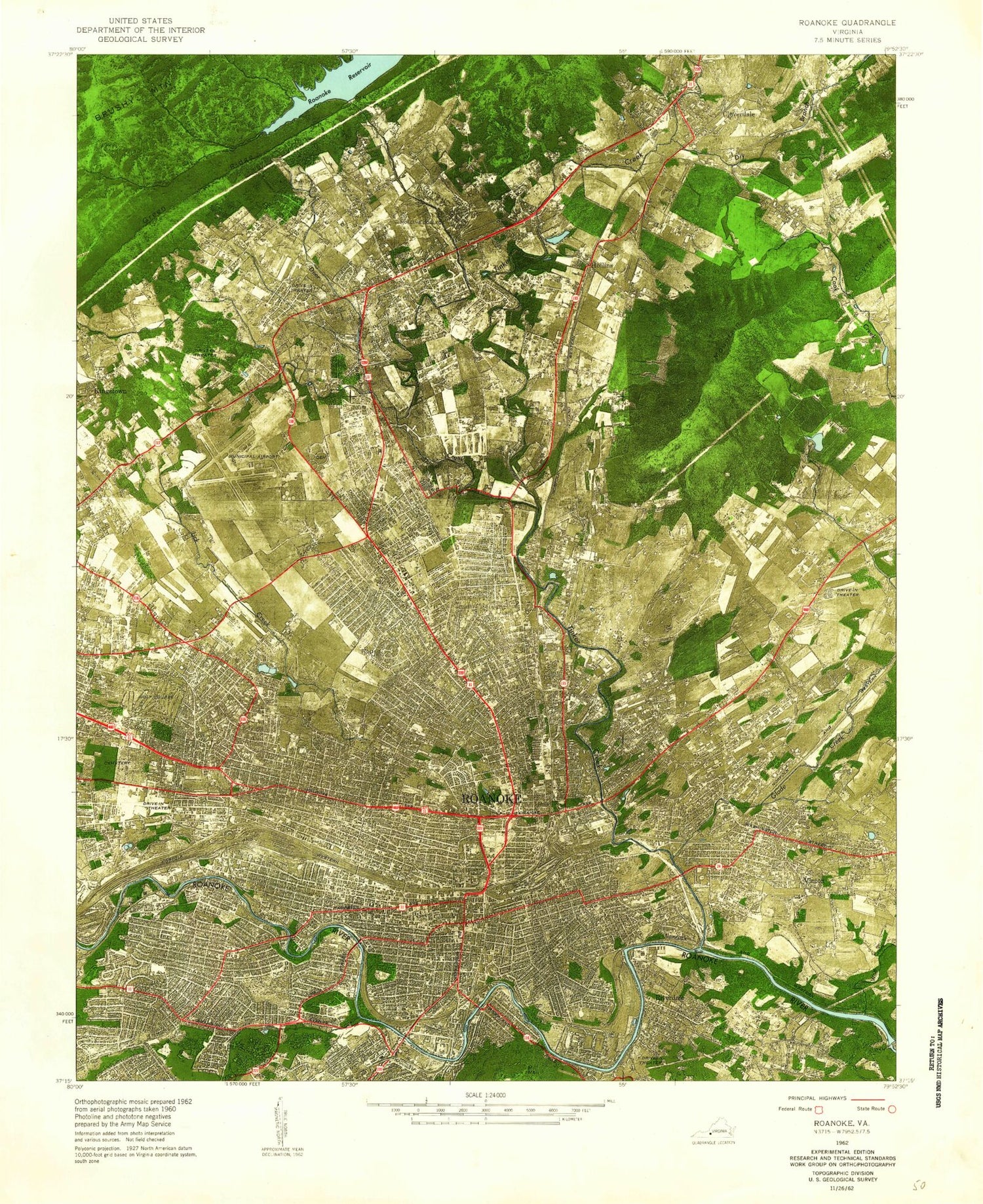
Classic USGS Roanoke Virginia 7.5'x7.5' Topo Map
Couldn't load pickup availability
Historical USGS topographic quad map of Roanoke in the state of Virginia. Typical map scale is 1:24,000, but may vary for certain years, if available. Print size: 24" x 27"
This quadrangle is in the following counties: Botetourt, Roanoke, Roanoke (city).
The map contains contour lines, roads, rivers, towns, and lakes. Printed on high-quality waterproof paper with UV fade-resistant inks, and shipped rolled.
Contains the following named places: Burlington Elementary School, Roland E Cook Alternative School, Craig Avenue School, Herman L Horn Elementary School, Ebenezer Church, Enon Church, Green Ridge, Hollins University, Hollins Elementary School, Horse Pen Branch, Mount Moriah Church, Mount View Cemetery, Mountain View Elementary School, Niagara Power Plant Dam, Northside High School, Northview Church, Obenchain Cemetery, Patterson Memorial Church, Read Mountain, Saint Phillips Church, South View Elementary School, Summerdean Church, Tombstone Cemetery, William Byrd High Schools, Mud Lick Creek, Belmont School, Beth Israel Cemetery, Blue Ridge Memorial Gardens, Booker T Washington School, James Breckinridge Middle School, East End Church, Elmwood Park, Emanuel Cemetery, Eureka Park, Evergreen Cemetery, Fair View Cemetery, Fairview Elementary School, Fallon Park, Forest Park Academy, Garnand Branch, Ghent Park, Gilmer School, Harrison School, Highland Park, Highland Park Elementary School, Hollins Road Church, Huff Lane Intermediate School, Hurt Park Elementary School, Jackson Park, Jamison Elementary School, Jefferson High School, Lakewood Park, Lee Junior High School, Lick Run, Lincoln Terrace Elementary School, Loudon School, Maher Field, Melrose School, Memorial Bridge Park, Mill Mountain Park, Roanoke Academy for Mathematics and Science, Monterey Elementary School, Morningside Park, Morningside Elementary School, Murray Run, Norwich Park, Oakland Intermediate School, Ore Branch, Our Lady of Nazareth School, Patrick Henry High School, Peters Creek, Preston Park Elementary School, Raleigh Court Park, Raleigh Court Elementary School, Round Hill Montessori Primary School, Saint Andrews Cemetery, Shrine Hill Park, South Roanoke Park, Stonewall Jackson Middle School, Thresher Park, Tinker Creek Elementary School, Towers Shopping Center, University of Virginia, Virginia Heights Elementary School, Wasena Park, Wasena Elementary School, Washington Heights Elementary School, Washington Park, Welford Hurt Park, West End School, Westside Elementary School, William Fleming High School, Williams Memorial Park, Woodrow Wilson Middle School, Roanoke-Blacksburg Regional Airport/Woodrum Field, Carvin Creek, Glade Creek, Tinker Creek, Wolf Creek, Carvins Cove Dam, Orchard Dam, Blue Hills Golf Club, Ole Monterey Golf Club, Roanoke Country Club, Roanoke Waterworks, Victory Stadium, Mill Mountain, City of Roanoke, Roanoke Memorial Hospital Heliport, Burrell Memorial Hospital, Cloverdale, Crossroads Mall Shopping Center, Gill Memorial Hospital, Hollins, Kingston, Lewis Gale Hospital, Memorial Hospital, Riverdale, Roanoke, Round Hill, Shenandoah Hospital, Vinton, WFIR-AM (Roanoke), WBNI-AM (Roanoke), WRIS-AM (Roanoke), WROV-AM (Roanoke), WKBA-AM (Vinton), WPIB-FM (Salem), WJLM-FM (Salem), British Woods, Old Dominion Memorial Gardens, Cloverdale Elementary School, Botetourt East, Apple Tree Village, Runaway Village, Oldfields, Alpine Hills, Applewood, Ardmore, Bali Hai, Belle Haven, Bellview Gardens, Blue Ridge Heights, Bowman, Boxley Hill, Brax-Han Court, Briarcliff, Brooklawn, Brookside, Brookside Golf Club, Brookside Shopping Center, Bryant Heights, Buckland Forest, Burlington Estates, Burlington Heights, Burnette Heights, Campbell Memorial Presbyterian Church, Captains Grove, Cocke Cemetery, Colonial Trail, Cornerstone Church, Craig Avenue Recreational Center, Dillard Court, Dillon Woods, Dwight Hills, Roanoke County Fire and Rescue Station 2 - Vinton Fire Department, First Christian Church, Green Ridge Presbyterian Church, Greenfield, Hedgelawn Gardens, Hollins Branch Roanoke County Library, Hollins College Quadrangle, Hollins Court, Hollins Station, Hollow Creek Swim Club, Howell, Huntridge, La Bellevue, Lake Drive Plaza Shopping Center, Lake Drive Swim Club, Lamplighter Mall Shopping Center, Lemonton, Malvern Hills, Market Square North Shopping Center, Meadewood, Midland Baptist Church, Midway Union Church, Mountain View, North Burlington Heights, North Hills, Northview Mobile Home Park, Oakland Estates, Old Dominion Court, Old Manor, Otterview Gardens, Petty Acres, Pilgrim Holiness Church, Plantation Court, Plantation Court Swim Club, Plymouth Colony, Reed Street Baptist Church, Richard Carver Cemetery, River Park Shopping Center, Central Middle School, Roanoke County Fire and Rescue Station 5 - Hollins Fire Company, Roanoke Valley Christian School, Ruddell Cemetery, Shenandoah Baptist Church, Sherry Court, Southampton, Starmount, Summerdean, Summerdean Gardens, Sun Valley, Sunnybrook, The Orchards, The Woodlands, Thornecrest, Thrasher Memorial United Methodist Church, Timberidge Acres, Tinker Knoll, Valleypointe Industrial Park, Vinton Baptist Church, Vinton Branch Roanoke County Library, Vinton Heights, Vinton Post Office, Vinton Sewage Disposal Plant, Vinton Wesleyan Church, Vista Heights, W E Cundiff Elementary School, Walrond Park, Waterfall Lake, Belmont Baptist Church, Belmont Christian Church, Belmont Church of God, Belmont Presbyterian Church