MyTopo
Classic USGS Rock Haven Kentucky 7.5'x7.5' Topo Map
Couldn't load pickup availability
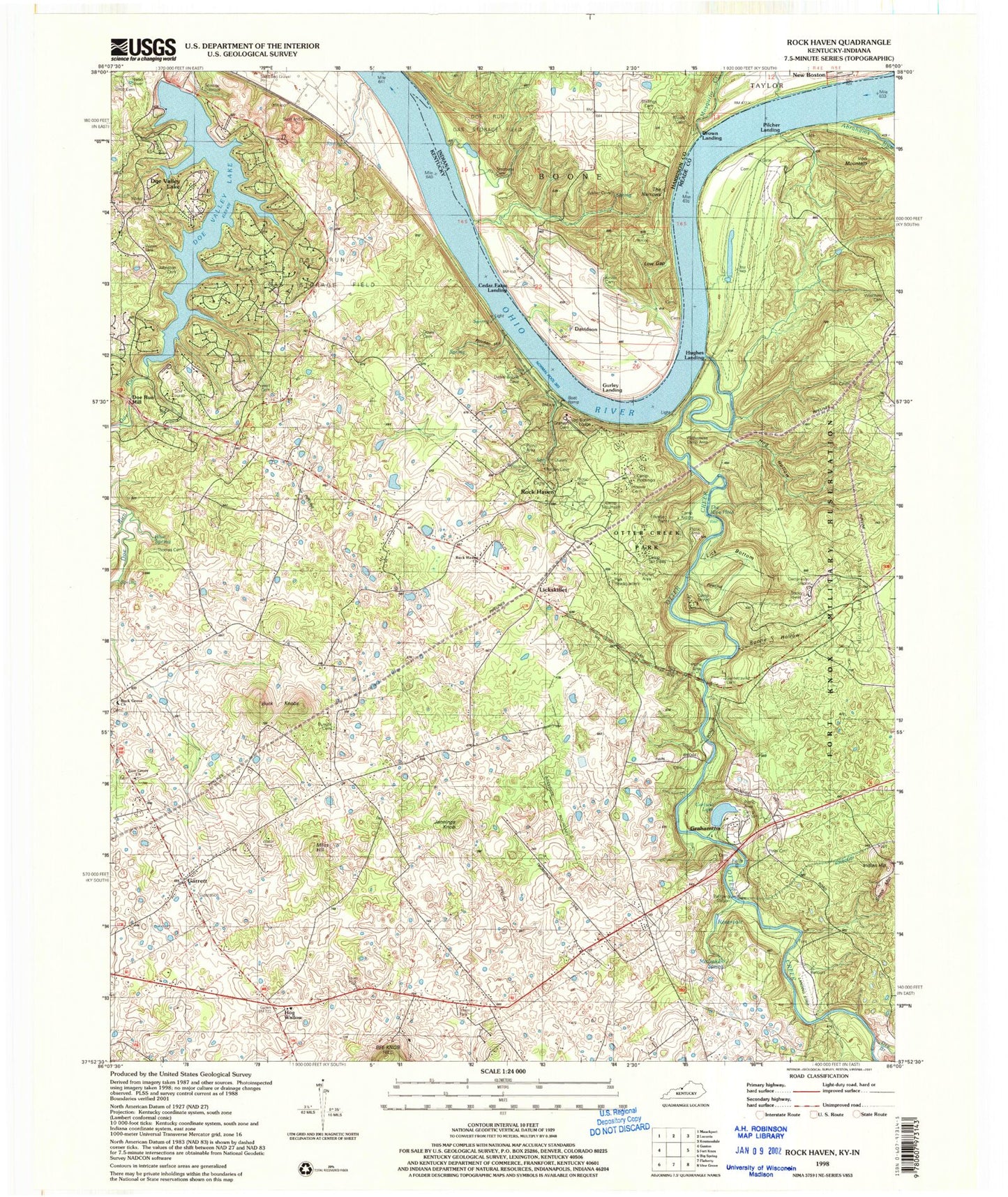
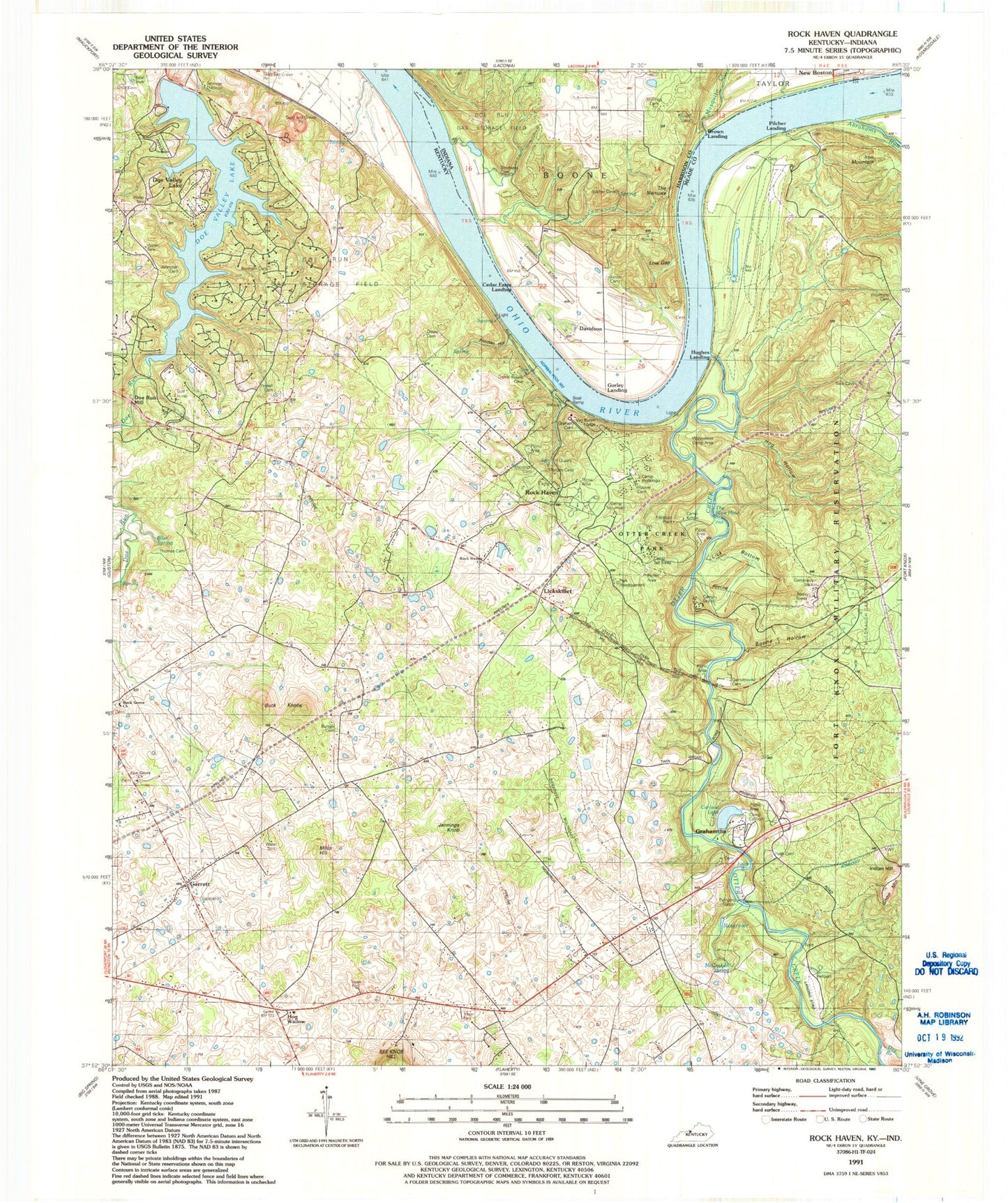
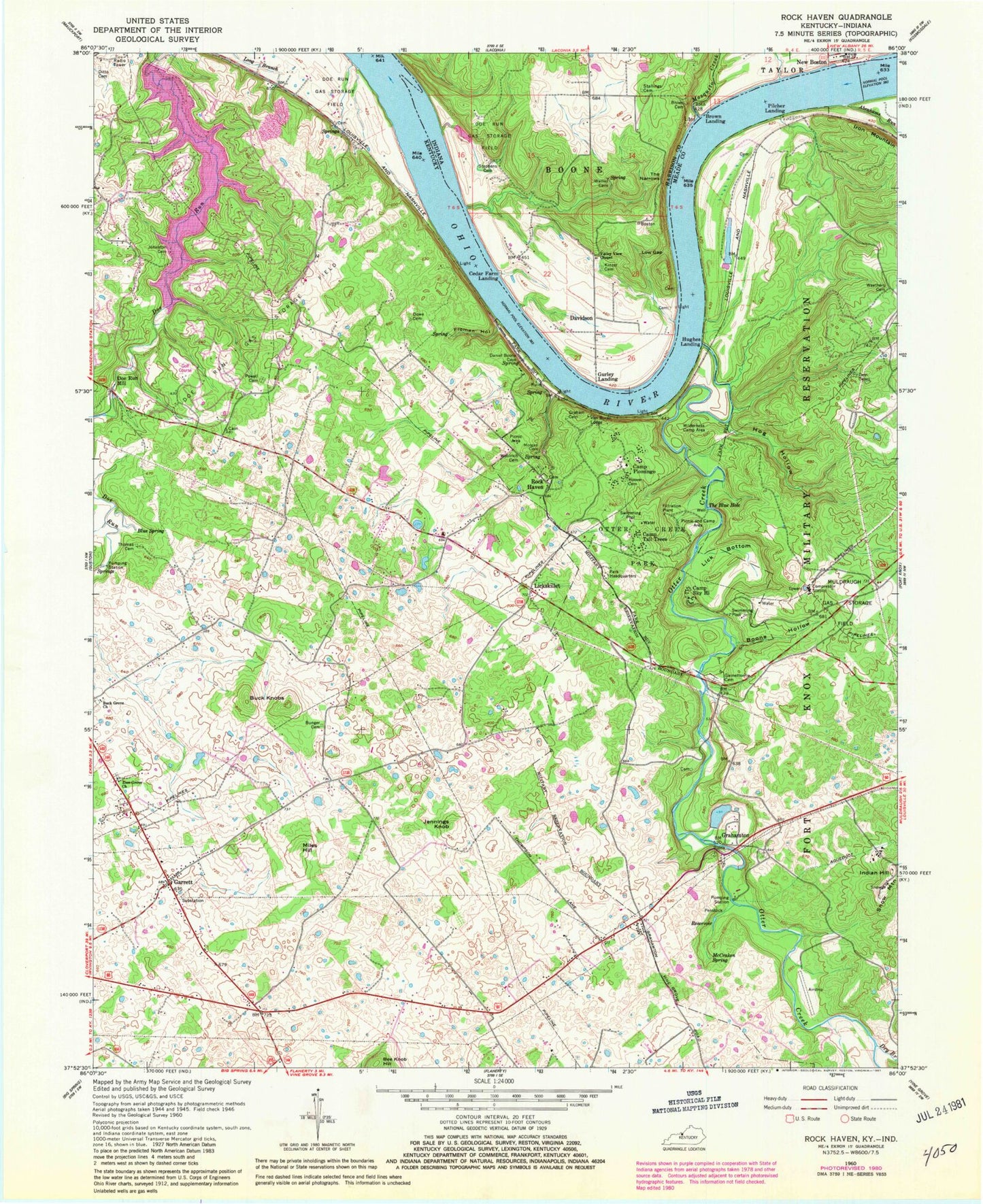
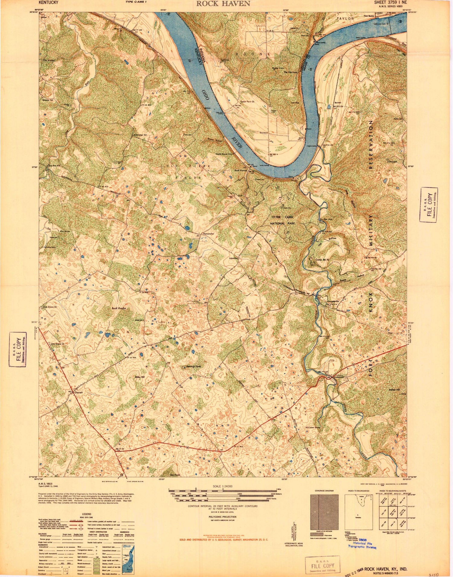
Historical USGS topographic quad map of Rock Haven in the states of Kentucky, Indiana. Typical map scale is 1:24,000, but may vary for certain years, if available. Print size: 24" x 27"
This quadrangle is in the following counties: Harrison, Meade.
The map contains contour lines, roads, rivers, towns, and lakes. Printed on high-quality waterproof paper with UV fade-resistant inks, and shipped rolled.
Contains the following named places: Abrahams Run, Boone Hollow, Buck Grove Church, Buck Knobs, Bunger Cemetery, Camp Piomingo, Camp Sky Hi, Camp Tall Trees, Ditto Cemetery, Doe Run Gas Storage Field, Doe Run Mill, Dowe Cemetery, Dry Branch, Froman Hollow, Garnettsville Cemetery, Garrett, Graham Cemetery, Hog Hollow, Hoover Cemetery, Indian Hill, Iron Mountain, Jennings Knob, Johnson Cemetery, Lick Bottom, McCraken Spring, Miles Hill, Muldraugh Gas Storage Field, Otter Creek, Otter Creek Park, Powell Cemetery, Snow Mountain, The Blue Hole, Thomas Cemetery, Van Buren Lodge, Withers Cemetery, Wilderness Camp Area, Woolrich Cemetery, Zion Grove Church, Grahamton, Hughes Landing, Lickskillet, Pilcher Landing, Rock Haven, Flaherty Division, Snow Mountain Air Force Station (historical), Doe Valley Census Designated Place, Doe Valley, Meade County Fire Protection District Station 2, Flaherty Fire and Rescue Department Station 2, Meade County Emergency Medical Services, Abrams Run, Blue Spring, Blue Spring Branch, Hog Wallow, Potter Creek, Rock Haven Valley, The Big Falls, Doe Valley Lake, Brown Cemetery, Davidson, Kinser Cemetery, Low Gap, Mosquito Creek, New Boston, Stallings Cemetery, Stephens Cemetery, The Narrows, Valley View Chapel, Cedar Farm Landing, Gurley Landing, Brown Landing, Cedar Farm Airport, Abrahams Run, Boone Hollow, Buck Grove Church, Buck Knobs, Bunger Cemetery, Camp Piomingo, Camp Sky Hi, Camp Tall Trees, Ditto Cemetery, Doe Run Gas Storage Field, Doe Run Mill, Dowe Cemetery, Dry Branch, Froman Hollow, Garnettsville Cemetery, Garrett, Graham Cemetery, Hog Hollow, Hoover Cemetery, Indian Hill, Iron Mountain, Jennings Knob, Johnson Cemetery, Lick Bottom, McCraken Spring, Miles Hill, Muldraugh Gas Storage Field, Otter Creek, Otter Creek Park, Powell Cemetery, Snow Mountain, The Blue Hole, Thomas Cemetery, Van Buren Lodge, Withers Cemetery, Wilderness Camp Area, Woolrich Cemetery, Zion Grove Church, Grahamton, Hughes Landing, Lickskillet, Pilcher Landing, Rock Haven, Flaherty Division, Snow Mountain Air Force Station (historical), Doe Valley Census Designated Place, Doe Valley, Meade County Fire Protection District Station 2, Flaherty Fire and Rescue Department Station 2, Meade County Emergency Medical Services, Abrams Run, Blue Spring, Blue Spring Branch, Hog Wallow, Potter Creek, Rock Haven Valley, The Big Falls, Doe Valley Lake, Brown Cemetery, Davidson, Kinser Cemetery, Low Gap, Mosquito Creek, New Boston, Stallings Cemetery, Stephens Cemetery, The Narrows, Valley View Chapel, Cedar Farm Landing, Gurley Landing, Brown Landing, Cedar Farm Airport, Abrahams Run, Boone Hollow, Buck Grove Church, Buck Knobs, Bunger Cemetery, Camp Piomingo, Camp Sky Hi, Camp Tall Trees, Ditto Cemetery, Doe Run Gas Storage Field, Doe Run Mill, Dowe Cemetery, Dry Branch, Froman Hollow, Garnettsville Cemetery, Garrett, Graham Cemetery, Hog Hollow, Hoover Cemetery, Indian Hill, Iron Mountain, Jennings Knob, Johnson Cemetery, Lick Bottom, McCraken Spring, Miles Hill, Muldraugh Gas Storage Field, Otter Creek, Otter Creek Park, Powell Cemetery, Snow Mountain, The Blue Hole, Thomas Cemetery, Van Buren Lodge, Withers Cemetery, Wilderness Camp Area, Woolrich Cemetery, Zion Grove Church, Grahamton, Hughes Landing, Lickskillet, Pilcher Landing, Rock Haven, Flaherty Division, Snow Mountain Air Force Station (historical), Doe Valley Census Designated Place, Doe Valley, Meade County Fire Protection District Station 2, Flaherty Fire and Rescue Department Station 2, Meade County Emergency Medical Services, Abrams Run, Blue Spring, Blue Spring Branch, Hog Wallow, Potter Creek, Rock Haven Valley, The Big Falls, Doe Valley Lake, Brown Cemetery, Davidson, Kinser Cemetery, Low Gap, Mosquito Creek, New Boston, Stallings Cemetery, Stephens Cemetery, The Narrows, Valley View Chapel, Cedar Farm Landing, Gurley Landing, Brown Landing, Cedar Farm Airport