MyTopo
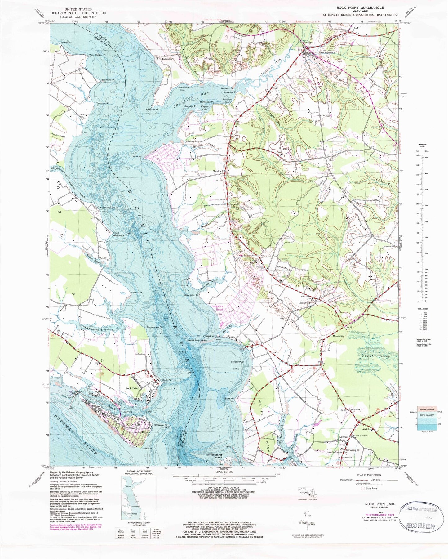
Classic USGS Rock Point Maryland 7.5'x7.5' Topo Map
Couldn't load pickup availability
Historical USGS topographic quad map of Rock Point in the state of Maryland. Typical map scale is 1:24,000, but may vary for certain years, if available. Print size: 24" x 27"
This quadrangle is in the following counties: Charles, St. Mary's.
The map contains contour lines, roads, rivers, towns, and lakes. Printed on high-quality waterproof paper with UV fade-resistant inks, and shipped rolled.
Contains the following named places: Barber Point, Charleston Creek, Dolly Boarmans Creek, Fennell Point, Hatton Creek, Maddox Creek, Neale Sound, Neale Sound Channel, Persimmon Point, Rock Point, Shipping Point, Stoddard Point, Tennyson Point, West Hatton Point, Wicomico Beach, Windmill Point, Cobb Island, Cobb Point, Rock Point, Woodberry Beach, Chaptico Creek, Abell School, Avenue, Avenue Branch, Bankhead Cove, Bankhead Point, Bassfold Creek, Bluff Point, Bramleigh Creek, Bramleigh Point, Bull Run, Bull Run, Burroughs Run, Bushwood, Bushwood Cove, Chaptico, Chaptico Bay, Chaptico Point, Chaptico Run, Christ Church, Church Swamp, Coffee Hill Run, Cohouck Point, Fenwick School, Hayden Cove, Hayden Point, Holy Angels Church, Hurry, Indiantown, Indiantown Cove, Indiantown Run, Longview Beach, Maddox, Manahowic Creek, Mattney Point, Milestown, Mill Creek, Mills Point, Nelsons Run, Our Lady of the Wayside Church, Pon Point, Sacred Heart Church, Saint Margaret Island, White Point, White Point Island, Whites Neck, Whites Neck Creek, Whites Neck Point, Wicomico River, Bushwood Wharf, Squier Landing, Nyce Airport (historical), White Point Bar, Camp Saint Charles, Charleston Creek, Cobb Bar, Cobb Island Post Office, Issue Post Office, Lancaster Bar, Lancaster Wharf, Our Ladys Manor, Rock Point Post Office (historical), Stoddert Bar, West Hatton, Anglican Chapel (historical), Avenue Post Office, Bachelors Hope, Barbers Quarter, Basford Manor, Bethune Elementary School, Blairs Purchase, Blakistone, Bloomfield, Bushwood Lodge (historical), Bushwood Manor House (historical), Bushwood Post Office, Cannons Old Field Bar, Chaptico Post Office, Chaptico Wharf, Christ Church Cemetery, Deep Falls (historical), Denby Hill, Dynard Elementary School, Elm Bar, Fosters Neck, Gravelly Hills, Green Springs, Hatchs Thicket, Holy Angels School, Hurry Post Office (historical), Keys Bar, Loretano, Lower Brambley (historical), Maddox Post Office, Maiden Bower, Mattapany Plantation, Mill Point (historical), Mill Point Bar, Mill Point Shores, Mouth of River Bar, Neales Hill, Notley Hall, Ocean Hall, Old Roots Bar, Old Wharf Landing, Penerine, Pond Point Bar, Ridgewood, Russell Landing, Sacred Heart Catholic Church, Sacred Heart Parochial School, Saint Catherine, Savona, Seventh District Community Park, South Hampton (historical), The Glebe, Upper Brambley (historical), Yellow Bank, Willow Glen, Clover Dale Acres, District 4 Chaptico, Cobb Island, Seventh District Volunteer Fire Department Company 5, Second District Volunteer Company and Rescue Squad 6, Cobb Island Volunteer Fire Department and Emergency Medical Services, Seventh District Volunteer Rescue Squad, Pirates Den Marina, Cobb Island Census Designated Place, Rock Point Census Designated Place