MyTopo
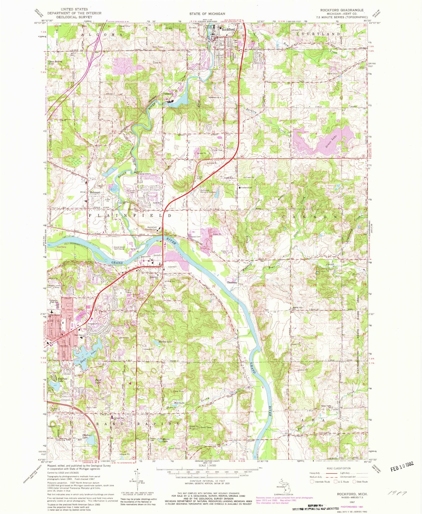
Classic USGS Rockford Michigan 7.5'x7.5' Topo Map
Couldn't load pickup availability
Historical USGS topographic quad map of Rockford in the state of Michigan. Map scale may vary for some years, but is generally around 1:24,000. Print size is approximately 24" x 27"
This quadrangle is in the following counties: Kent.
The map contains contour lines, roads, rivers, towns, and lakes. Printed on high-quality waterproof paper with UV fade-resistant inks, and shipped rolled.
Contains the following named places: Airway Township Park, Armstrong Creek, Assumption School, Austerlitz Post Office, Austerlitz Post Office Historical Marker, Ball Lake, Barkley Creek, Bear Creek, Bella Vista Church, Belmont, Belmont Baptist Church, Belmont Elementary School, Belmont Post Office, Belmont Station, Blythefield Christian Reformed Church, Blythefield Country Club, Blythefield Hills Baptist Church, Blythefield Memory Gardens, Cahill Park, Cannonsburg Ski Area, Celebration Village Shopping Center, Chapel Post Office, Charter Township of Plainfield, Chauncey, Chauncey Post Office, Childsdale, Childsdale Post Office, Childsdale Station, Christ Our Savior Evangelical Lutheran Church, Church of the Assumption, Crestwood School, Crossroads Wesleyan Church, Dean Lake, Dunlop Lake, East Oakview School, Eastern High School, Egypt Creek, Egypt Valley Country Club, Egypt Valley School, Emerald Lake, Family Physicians Clinic, First Congregational Church, Friant Cemetery, Front Line Community Church, Garden Club Park, Grace Community Church, Grand Island Golf Course, Grand Rapids Charter Township Fire Department Station 2, Grand Rogue Campgrounds, Grass Lake, Heritage Parkland, Highland School, Hope Community Church, Hyser Rivers Museum, Imperial Mills Post Office, Jehovah's Witnesses, Kent County, Knapp Forest Elementary School, Krause Memorial Library, Leisure Village Mobile Home Park, Linh Son Temple, Luton Park, Mason Cemetery, Mason Lake, Meadow Ridge Elementary School, Memorial Park, Messiah Lutheran Church, Moffitt Hill School, New Community Church, North Kent Bible Church of God, North Kent Church, North Oakview School, North Rockford Middle School, Northland Baptist Church, Northland Church, Northview, Northview Alternative School, Northview Census Designated Place, Northview Community of Christ Church, Northview High School, Oakview Church, Oakwood Cemetery, Old Reformed Congregation, Orchard View Church of God, Orchard View School, Peppler Park, Perch Lake, Pickett Park, Plainfield Branch Library, Plainfield Fire Department Station 3, Plainfield Township Cemetery and Columbarium, Plainfield Township Fire Department Station 1, Provin Trails Park, Reformed Bible College, Resurrection Life Worship Center, Richardson School, Richardson-Sowerby Park, River Rock Church, River Valley Academy, Rockford, Rockford Ambulance, Rockford Area Historical Museum, Rockford Baptist Church, Rockford Cemetery, Rockford City Hall, Rockford Department of Public Safety - Fire Facility, Rockford Department of Public Safety - Police Facility, Rockford Freshman Center, Rockford Health Center, Rockford High School, Rockford Pioneer Cemetery, Rockford Post Office, Rockford Station, Rockford United Methodist Church, Rogue River, Rogue River Park, Roguewood Elementary School, Rotary Park, Rum Creek, Saint Lukes Lutheran Church, Saint Mary's Cemetery, Saint Peter's Lutheran Church, Saint Stephen Lutheran Church, Shadow Lake, Spring Valley Mobile Home Park, Stout Creek, Sunny Creek, Sunshine Community Church, Thousand Oaks Golf Club, Three Angels Fellowship Church, Trinity Church, Versluis Lake, Victory Church, Vineyard Christian Fellowship, Waddell Creek, WCUZ-FM (Grand Rapids), WEHB-FM (Grand Rapids), West Cannon Baptist Church, White Pines United Methodist Church, William Hyser Historical Marker, WJPW-AM (Rockford), WLAV-FM (Grand Rapids), Woodland Estates Mobile Home Park, ZIP Codes: 49306, 49525