MyTopo
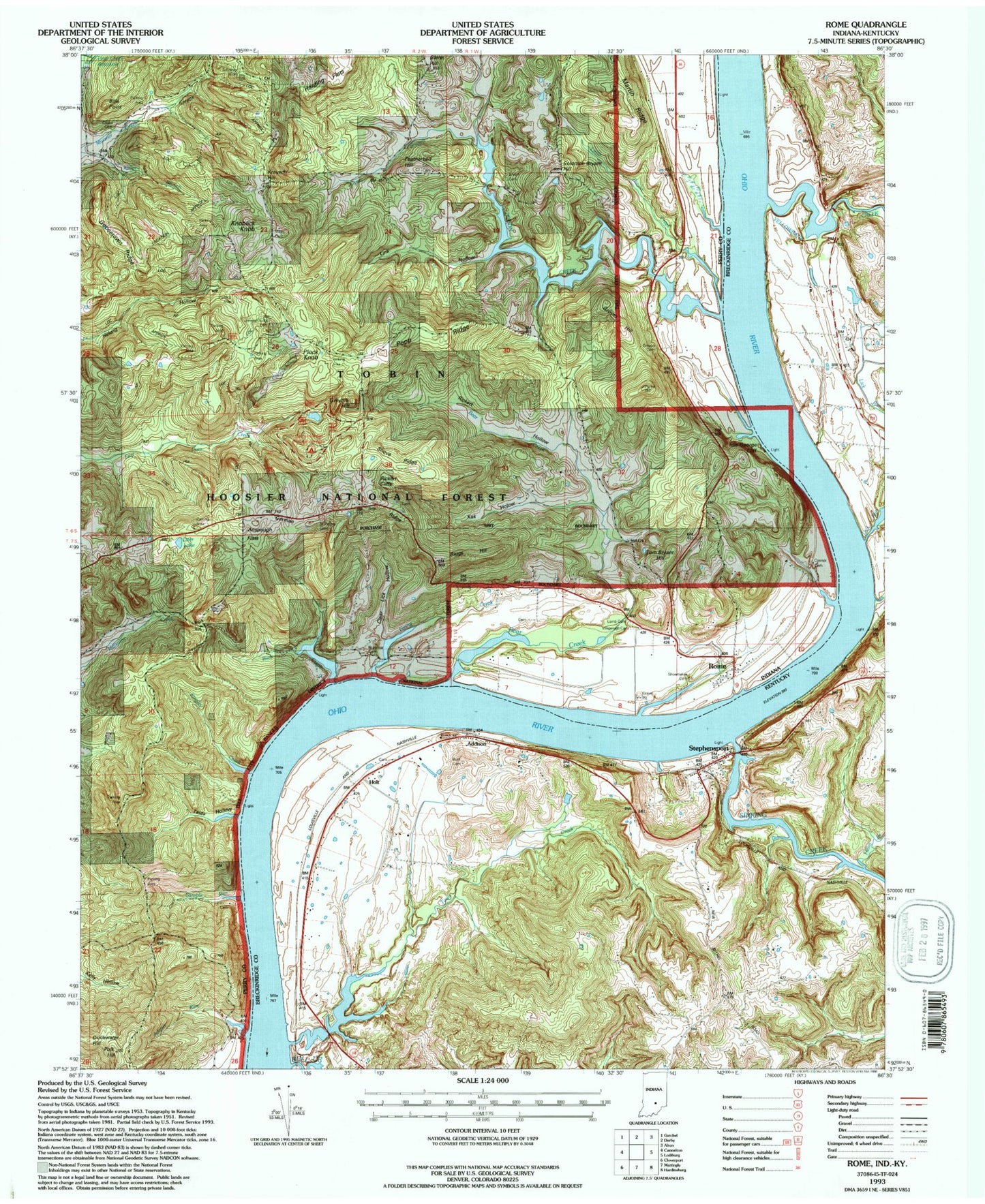
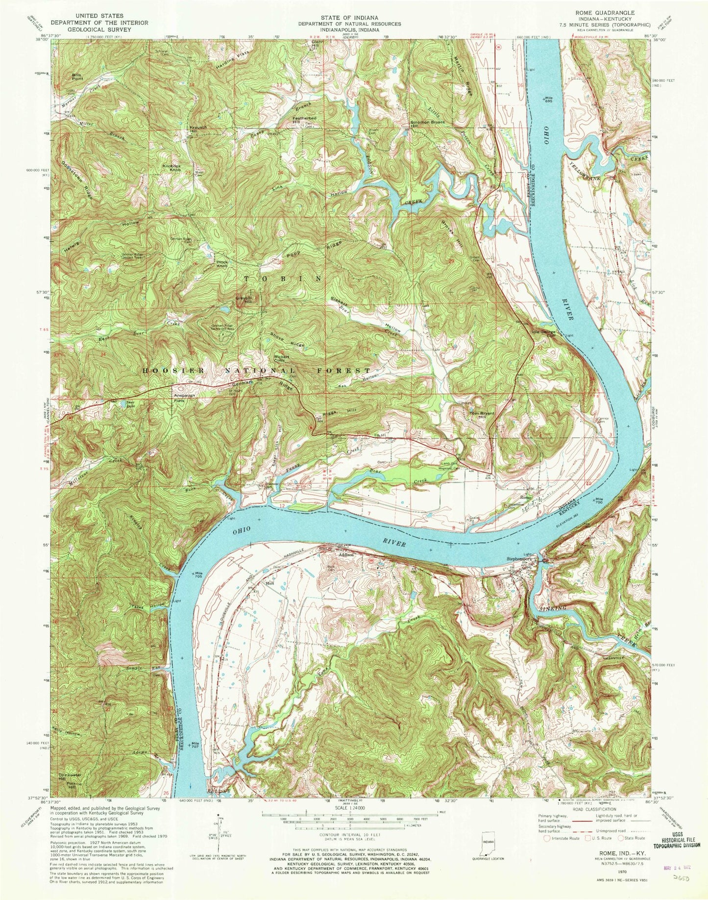
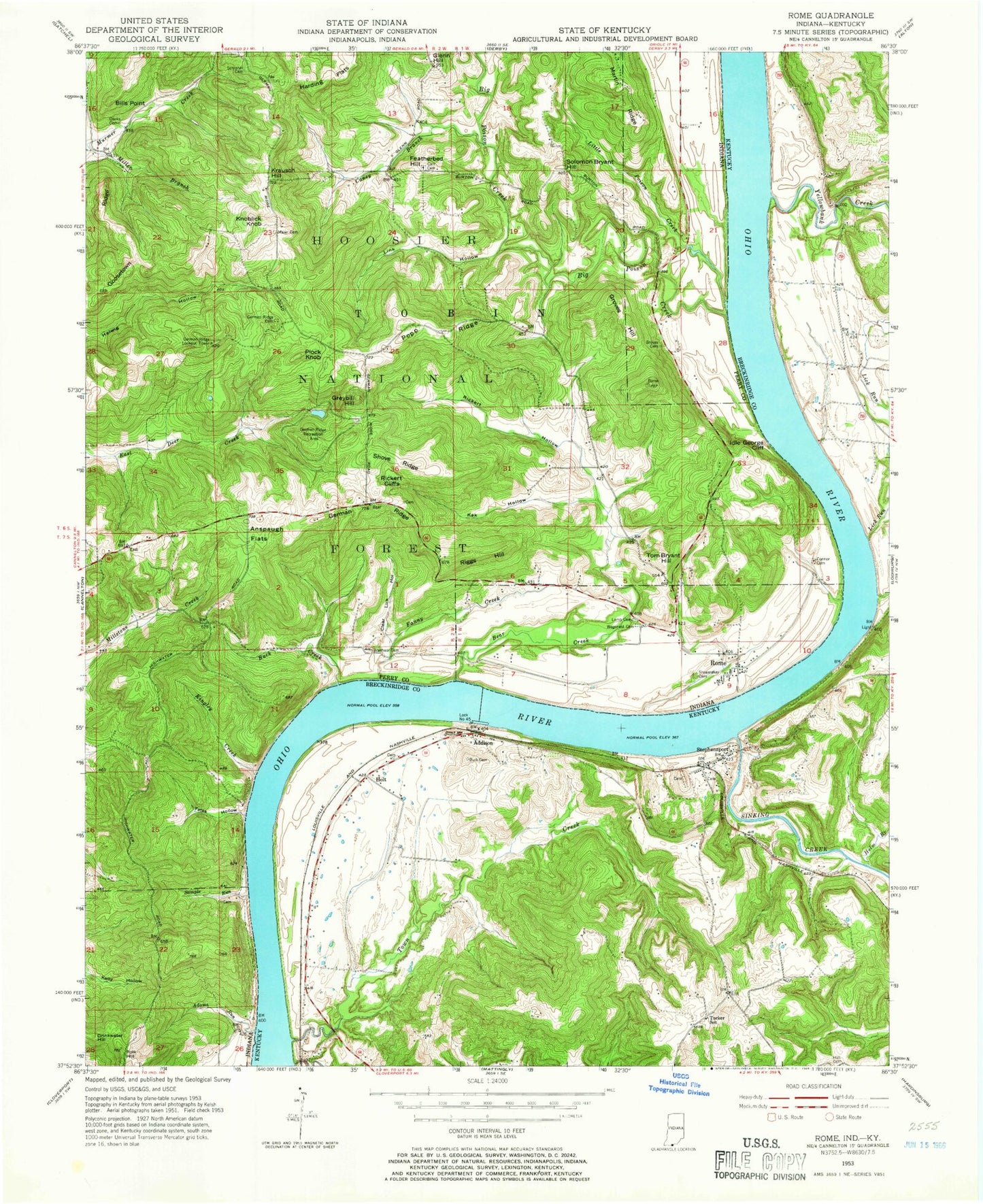
Classic USGS Rome Indiana 7.5'x7.5' Topo Map
Couldn't load pickup availability
Historical USGS topographic quad map of Rome in the states of Indiana, Kentucky. Typical map scale is 1:24,000, but may vary for certain years, if available. Print size: 24" x 27"
This quadrangle is in the following counties: Breckinridge, Perry.
The map contains contour lines, roads, rivers, towns, and lakes. Printed on high-quality waterproof paper with UV fade-resistant inks, and shipped rolled.
Contains the following named places: Buck Creek, Adams Run, Anspaugh Flats, Bear Creek, Bills Point, Brashear Cemetery, Caney Branch, Carr Cemetery, Clear Lick Hollow, Connor Cemetery, Cooks Cemetery, Deer Lake, Drinkwater Hill, Fanny Creek, Featherbed Hill, German Ridge, German Ridge Cemetery, German Ridge Lookout Tower, Goosetown Ridge, Greybill Hill, Groves Cemetery, Groves Hill, Harding Flats, Idle George Cliff, Kak Hollow, Kingley Creek, Knoblick Knob, Lamb Cemetery, Link Hollow, Little Poison Creek, Martin Ridge, Plock Knob, Poison Creek, Polk Hill, Popp Ridge, Rickert Hollow, Riggs Hill, Rome, Saint Peter Cemetery, Sample Run, Schraner Cemetery, Shoemaker Cemetery, Shove Ridge, Solomon Bryant Hill, Tates Hollow, Tom Bryant Hill, Wegenast Cemetery, Hardingrove, Lauer, Rickert Cliffs, East Deer Pond, Gerber Pond, Krausch Hill, Maier Cemetery, German Ridge Recreation Area, Bryant Cemetery, Township of Tobin, Rome Volunteer Fire Department, Addison, Bull Creek, Burk Cemetery, Helm Branch, Holt, Lick Run, Sinking Creek, Stephensport, Town Creek, Yellowbank Creek, Stephensport Volunteer Fire Department, Holt Bottom, Stephensport Post Office, Buck Creek, Adams Run, Anspaugh Flats, Bear Creek, Bills Point, Brashear Cemetery, Caney Branch, Carr Cemetery, Clear Lick Hollow, Connor Cemetery, Cooks Cemetery, Deer Lake, Drinkwater Hill, Fanny Creek, Featherbed Hill, German Ridge, German Ridge Cemetery, German Ridge Lookout Tower, Goosetown Ridge, Greybill Hill, Groves Cemetery, Groves Hill, Harding Flats, Idle George Cliff, Kak Hollow, Kingley Creek, Knoblick Knob, Lamb Cemetery, Link Hollow, Little Poison Creek, Martin Ridge, Plock Knob, Poison Creek, Polk Hill, Popp Ridge, Rickert Hollow, Riggs Hill, Rome, Saint Peter Cemetery, Sample Run, Schraner Cemetery, Shoemaker Cemetery, Shove Ridge, Solomon Bryant Hill, Tates Hollow, Tom Bryant Hill, Wegenast Cemetery, Hardingrove, Lauer, Rickert Cliffs, East Deer Pond, Gerber Pond, Krausch Hill, Maier Cemetery, German Ridge Recreation Area, Bryant Cemetery, Township of Tobin, Rome Volunteer Fire Department, Addison, Bull Creek, Burk Cemetery, Helm Branch, Holt, Lick Run, Sinking Creek, Stephensport, Town Creek, Yellowbank Creek, Stephensport Volunteer Fire Department, Holt Bottom, Stephensport Post Office