MyTopo
Classic USGS Rough And Ready California 7.5'x7.5' Topo Map
Couldn't load pickup availability
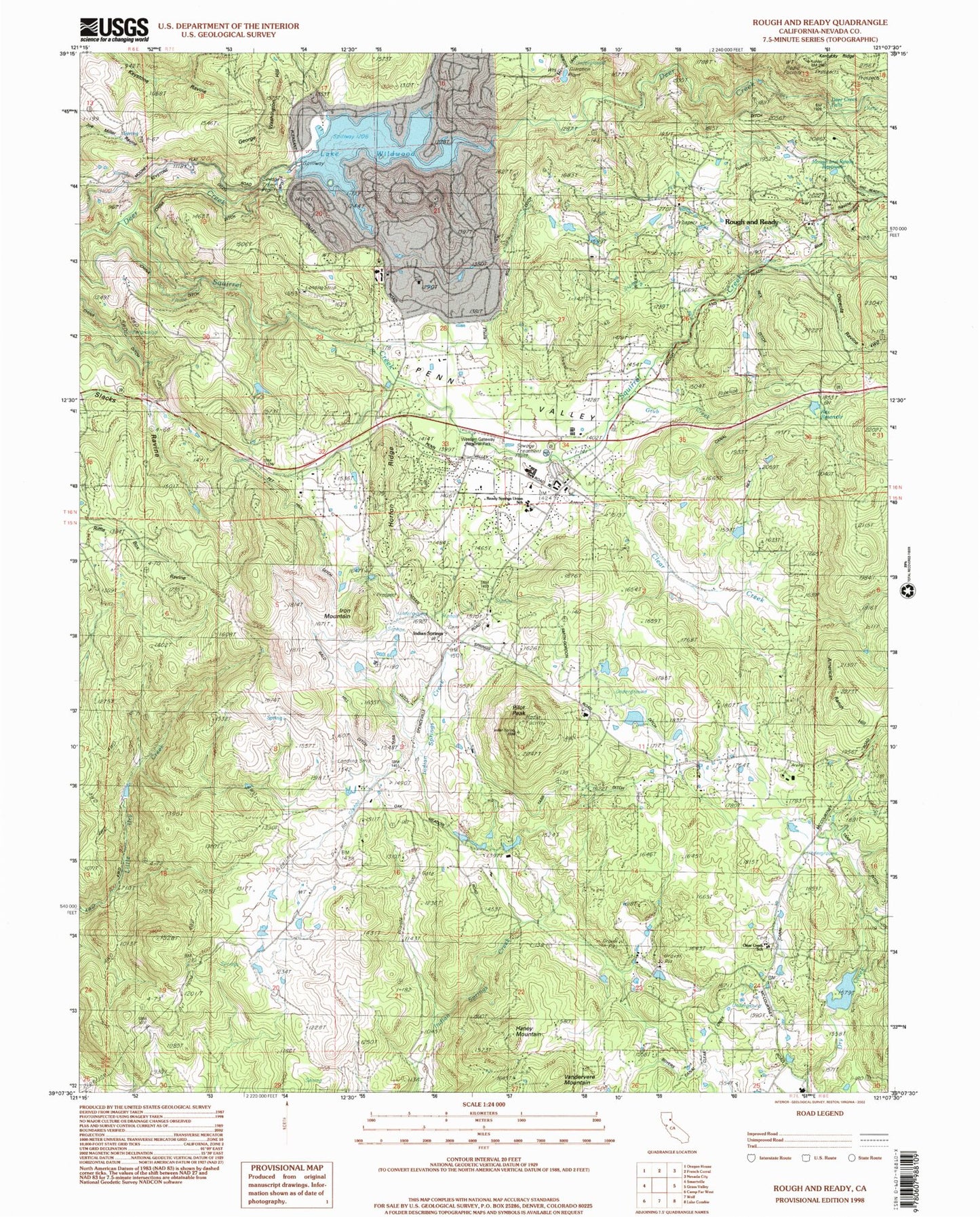
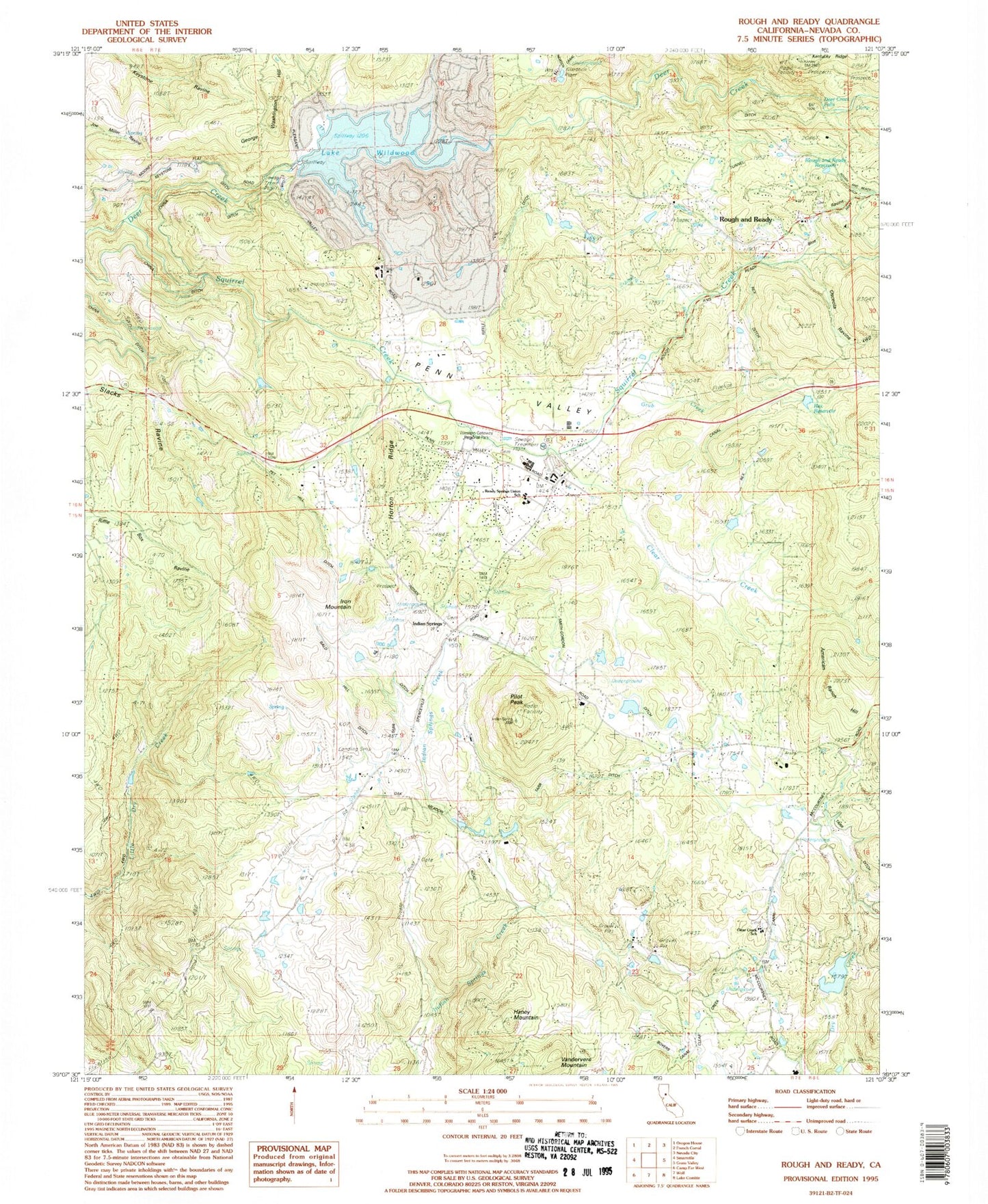
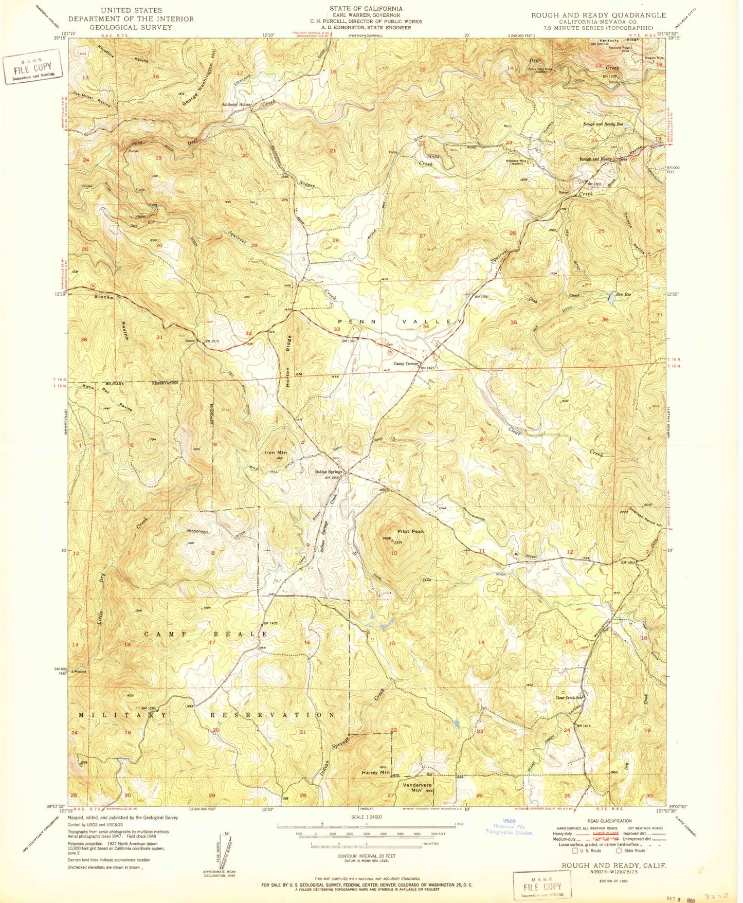
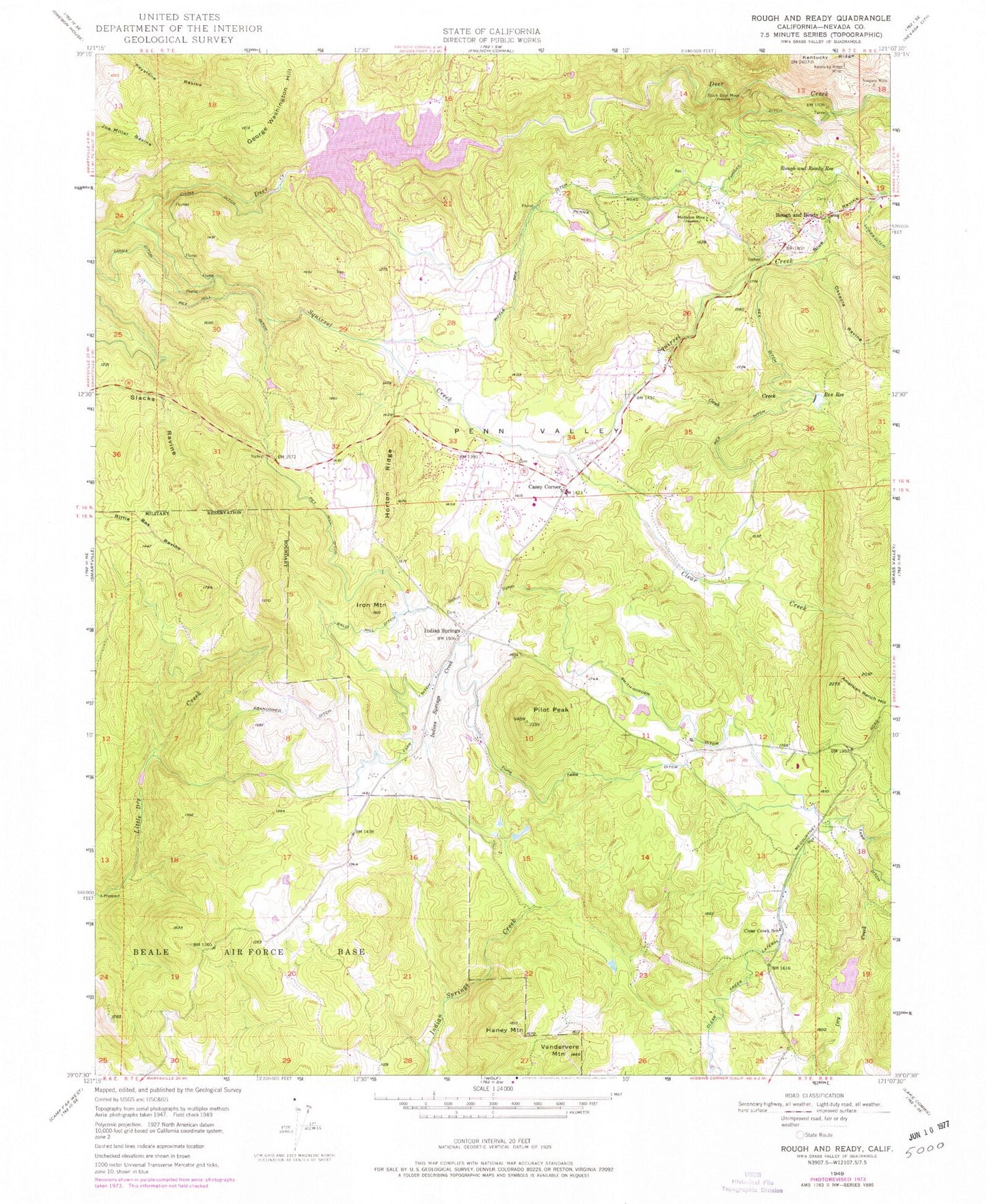
Historical USGS topographic quad map of Rough And Ready in the state of California. Typical map scale is 1:24,000, but may vary for certain years, if available. Print size: 24" x 27"
This quadrangle is in the following counties: Nevada.
The map contains contour lines, roads, rivers, towns, and lakes. Printed on high-quality waterproof paper with UV fade-resistant inks, and shipped rolled.
Contains the following named places: Bald Hill Ditch, Black Bear Mine, Clear Creek, Clear Creek Elementary School, Deer Creek, Grub Creek, Haney Mountain, Horton Ridge, Indian Springs, Kentucky Ridge, Kentucky Ridge Mine, Lower Ditch, Mistletoe Mine, Niagara Mine, Osceola Ravine, Penn Valley, Pet Hill Ditch, Pilot Peak, Rex Ditch, Rex Reservoir, Riffle Box Ditch, Rough and Ready Reservoir, Blue Ravine, Clear Creek Lateral, Smith-Gordon Ditch, Squirrel Creek, Tarr Ditch, Tunnel Ditch, Vandervere Mountain, Limberlost Ranch Airport, Casey Corner, George Washington Hill, Iron Mountain, Rough and Ready, Anthony House 1300-002 Dam, Lake Wildwood, Swan 1301 Dam, Bugler Cove Park, Forest Circle Park, Lake Wildwood, Meadow Park, Miners Gulch Park, Peacock Point, Pine Island Beach, Ready Springs Elementary School, Rough and Ready Cemetery, Rough and Ready Grange Hall, Vista Park, Western Gateway Regional Park, Penn Valley, Lake Wildwood Census Designated Place, Penn Valley Census Designated Place, Rough and Ready Fire Station, Penn Valley Fire Protection District Station 44, Penn Valley Fire Protection District Station 43, Rough and Ready Census Designated Place, Negro Creek, Penn Valley Post Office, Rough and Ready Post Office, Indian Springs Cemetery, Penn Valley Cemetery, Clear Creek Cemetery, Bald Hill Ditch, Black Bear Mine, Clear Creek, Clear Creek Elementary School, Deer Creek, Grub Creek, Haney Mountain, Horton Ridge, Indian Springs, Kentucky Ridge, Kentucky Ridge Mine, Lower Ditch, Mistletoe Mine, Niagara Mine, Osceola Ravine, Penn Valley, Pet Hill Ditch, Pilot Peak, Rex Ditch, Rex Reservoir, Riffle Box Ditch, Rough and Ready Reservoir, Blue Ravine, Clear Creek Lateral, Smith-Gordon Ditch, Squirrel Creek, Tarr Ditch, Tunnel Ditch, Vandervere Mountain, Limberlost Ranch Airport, Casey Corner, George Washington Hill, Iron Mountain, Rough and Ready, Anthony House 1300-002 Dam, Lake Wildwood, Swan 1301 Dam, Bugler Cove Park, Forest Circle Park, Lake Wildwood, Meadow Park, Miners Gulch Park, Peacock Point, Pine Island Beach, Ready Springs Elementary School, Rough and Ready Cemetery, Rough and Ready Grange Hall, Vista Park, Western Gateway Regional Park, Penn Valley, Lake Wildwood Census Designated Place, Penn Valley Census Designated Place, Rough and Ready Fire Station, Penn Valley Fire Protection District Station 44, Penn Valley Fire Protection District Station 43, Rough and Ready Census Designated Place, Negro Creek, Penn Valley Post Office, Rough and Ready Post Office, Indian Springs Cemetery, Penn Valley Cemetery, Clear Creek Cemetery, Bald Hill Ditch, Black Bear Mine, Clear Creek, Clear Creek Elementary School, Deer Creek, Grub Creek, Haney Mountain, Horton Ridge, Indian Springs, Kentucky Ridge, Kentucky Ridge Mine, Lower Ditch, Mistletoe Mine, Niagara Mine, Osceola Ravine, Penn Valley, Pet Hill Ditch, Pilot Peak, Rex Ditch, Rex Reservoir, Riffle Box Ditch, Rough and Ready Reservoir, Blue Ravine, Clear Creek Lateral, Smith-Gordon Ditch, Squirrel Creek, Tarr Ditch, Tunnel Ditch, Vandervere Mountain, Limberlost Ranch Airport, Casey Corner, George Washington Hill, Iron Mountain, Rough and Ready, Anthony House 1300-002 Dam, Lake Wildwood, Swan 1301 Dam, Bugler Cove Park, Forest Circle Park, Lake Wildwood, Meadow Park, Miners Gulch Park, Peacock Point, Pine Island Beach, Ready Springs Elementary School, Rough and Ready Cemetery, Rough and Ready Grange Hall, Vista Park, Western Gateway Regional Park, Penn Valley, Lake Wildwood Census Designated Place, Penn Valley Census Designated Place, Rough and Ready Fire Station, Penn Valley Fire Protection District Station 44, Penn Valley Fire Protection District Station 43, Rough and Ready Census Designated Place, Negro Creek, Penn Valley Post Office, Rough and Ready Post Office, Indian Springs Cemetery, Penn Valley Cemetery, Clear Creek Cemetery