MyTopo
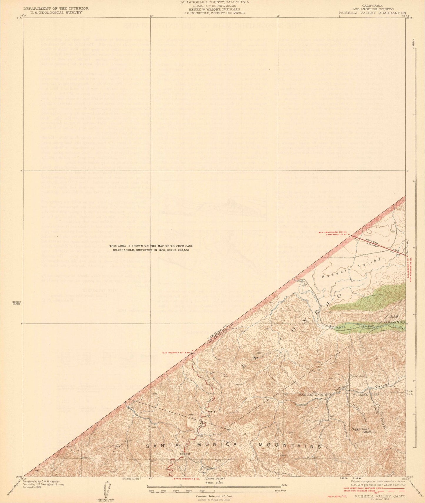
Classic USGS Russell Valley California 7.5'x7.5' Topo Map
Couldn't load pickup availability
Historical USGS topographic quad map of Russell Valley in the state of California. Typical map scale is 1:24,000, but may vary for certain years, if available. Print size: 24" x 27"
This quadrangle is in the following counties: Los Angeles, Ventura.
The map contains contour lines, roads, rivers, towns, and lakes. Printed on high-quality waterproof paper with UV fade-resistant inks, and shipped rolled.
Contains the following named places: Conejo Elementary School, El Conejo, Lake Eleanor, Hidden Valley, Lake Eleanor Creek, Little Trough Canyon, Schoolhouse Canyon, Lake Sherwood, Skeleton Canyon, Trough Canyon, Windmill Canyon, Westlake Medical Center Heliport, Los Robles Greens Country Club, Greenwich Village, Thousand Oaks, Triunfo Corner, Westlake Village, Lake Sherwood 765 Dam, Lake Eleanor 1763 Dam, Potrero 786 Dam, Westlake Reservoir 1073 Dam, Ballard Mountain, Bennett Park, Saint Jude the Apostle School, Westlake Medical Center (historical), Westlake Village Golf Course, Evenstar Park, Madrona Elementary School, Redwood Intermediate School, Baptist Academy, Church of Christ, Conejo Valley School District Office, First Baptist Church, Kingdom Hall of Jehovahs Witnesses, Lakeview Canyon Golf Course, Meadows Elementary School, North Ranch, North Ranch Area Community Center, North Ranch Country Club, North Ranch Park, Acacia Elementary School, Agape Christian Fellowship Church, Arts Council Center, Ascension Lutheran School, Beyer Park, Cameron Center, The Church of Jesus Christ of Latter Day Saints, Church of the Oaks, Civic Arts Plaza, Colina Intermediate School, Conejo Community Park, Conejo Creek Park, Conejo Ridge Open Space, Conejo Valley Botanic Gardens, Conejo Valley Church of Christ, Conejo Valley Church of Religious Science, Conejo Valley Community Center, Conejo Valley Plaza Shopping Center, Conejo Valley Post Office, El Cid Plaza Shopping Center, El Parque de la Paz, Estella Park, Faith Tabernacle United Pentecostal Church, Glenwood Elementary School, Glenwood Park, Hillcrest Christian Center, Hillcrest Christian School, Hope Nature Preserve, Janss Mall Shopping Center, La Siesta Plaza Shopping Center, Lake Eleanor Open Space, Little Oaks School, Los Padres Open Space, Los Robles Open Space, North Ranch Mall Shopping Center, Nuville Shopping Center, Old Towne Center Shopping Center, Palm Plaza Shopping Center, Redeemer Lutheran Church, Russell Park, Skyline Plaza Shopping Center, South Shore Hills Park, Sun Plaza Shopping Center, Sunset Plaza Shopping Center, Temple Adat Elohim, Evergreens Shopping Center, Oaks Shopping Center, The Shepherds Gate Foursquare Church, Triunfo Community Park, Village Court Shopping Center, Village Square Shopping Center, Walnut Grove Park, Westlake Elementary School, Westlake High School, Westlake Elementary School, Westlake Plaza Shopping Center, Westoaks-Hampshire Shopping Center, Westlake Lake, City of Thousand Oaks, City of Westlake Village, Lake Sherwood Census Designated Place, Los Robles Regional Medical Center, Thousand Oaks Surgical Hospital, Los Angeles County Fire Department Station 144, Ventura County Fire Protection District Station 33 - Lake Sherwood, Ventura County Fire Department Station 37 North Ranch, Ventura County Fire Department Station 31 - Westlake, Ventura County Fire Protection District Station 30 Civic Center, Thousand Oaks Post Office