MyTopo
Classic USGS Russellville Alabama 7.5'x7.5' Topo Map
Couldn't load pickup availability
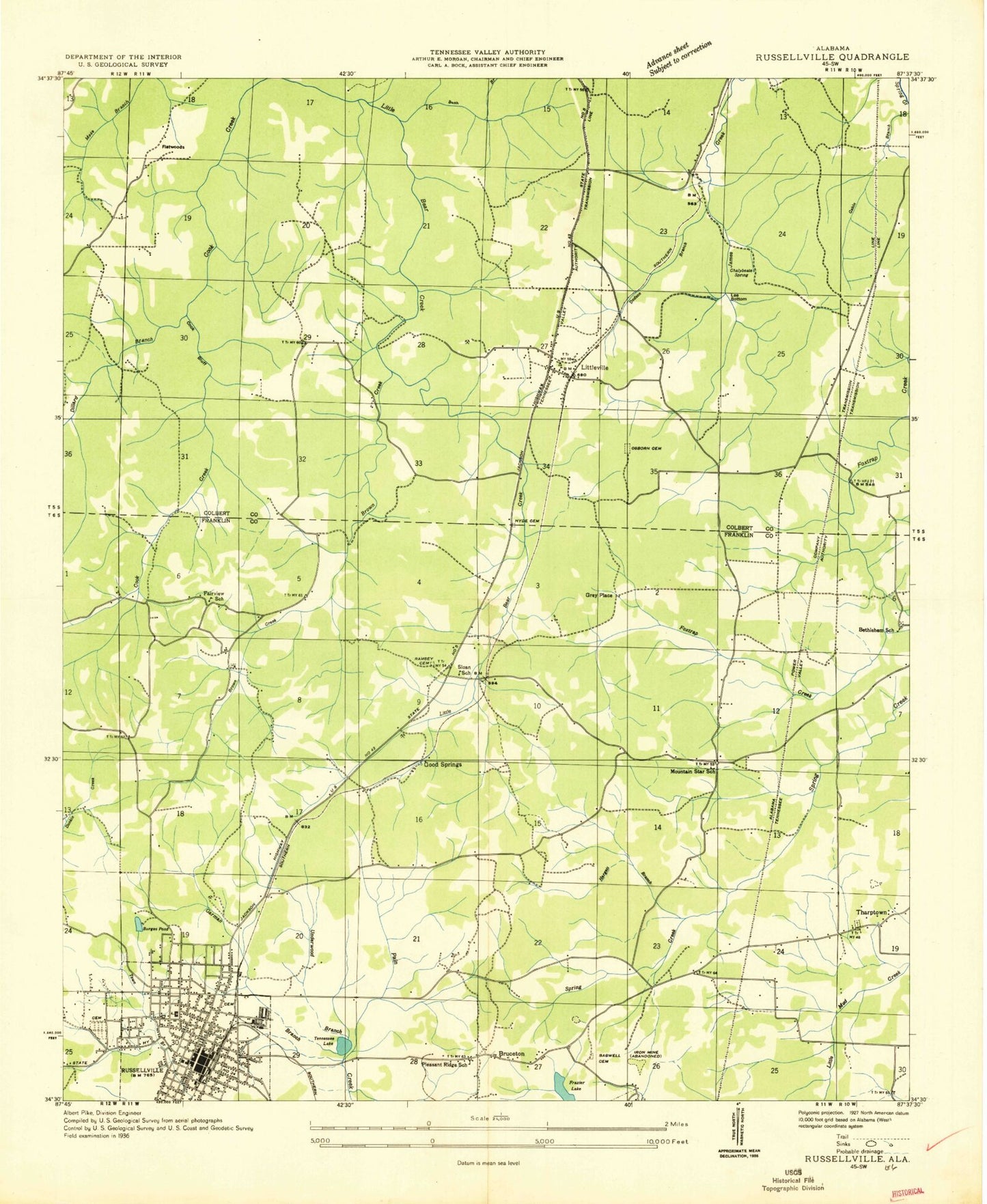
Historical USGS topographic quad map of Russellville in the state of Alabama. Typical map scale is 1:24,000, but may vary for certain years, if available. Print size: 24" x 27"
This quadrangle is in the following counties: Colbert, Franklin.
The map contains contour lines, roads, rivers, towns, and lakes. Printed on high-quality waterproof paper with UV fade-resistant inks, and shipped rolled.
Contains the following named places: Alva Chapel, Bethlehem Church, Bobo Cemetery, Bush Branch, Calvary Missionary Baptist Church, Chalybeate Spring, City Lake, Coburn Mountain, Cook Bluff, Dillard Branch, Dodson Branch, Foxtrap Church of Christ, Franklin Memory Gardens, Frazier Lake, Friendship Baptist Church, Garman Branch, Good Spring, Gravel Hill Cemetery, Hargett Branch, Hargett Creek, Henson Cemetery, Hester Heights, Hyde Cemetery, Hyde Lake, Jordan Point, Knights of Pythias Cemetery, Lee Bottom, Luketown Cemetery, Mountain Star, Nebo Hill, Russellville Hospital, North Highlands Church, Number Six Lake, Osborn Hill Cemetery, Pleasant Ridge, Ramsey Cemetery, Robinson Cemetery, Rocky Branch, Russellville, Seal Spring, Seal Spring, Tharp Cemetery, Tharptown Springs, Underwood Creek, Wesley Memorial Church, Young Cemetery, Hyde Lake Dam, Ligon Springs Church of Christ, Ligon Springs Church, Ligon Springs School (historical), Littleville First Baptist Church, Underwood Heights Elementary School, Asbury United Methodist Church, Bethlehem Cemetery, Bethlehem School (historical), Bruceton, Calvary Baptist Church, College Avenue First Baptist Church, College Avenue School, Concord Baptist Church, Devaney Cemetery, East Side Church of Christ, East Side Missionary Baptist Church, Ebeneezer Church, Evening Shade Church (historical), Evening Shade School (historical), Fairview School (historical), First Baptist Church, First Presbyterian Church, First United Methodist Church, Franklin County Farm (historical), Gaines Street Baptist Church, Lake Leola, North Russellville Baptist Church, Old Bethlehem School (historical), Old Town Cemetery, Pleasant Ridge School (historical), Russellville Church of God, Russellville Freewill Baptist Church, Russellville High School, Russellville Middle School, Sadler Cemetery, Sloan School (historical), Tharptown Cemetery, Tharptown Baptist Church, Tharptown Church of Christ, Washington Avenue Church of Christ, West Highlands Baptist Church, Westside Elementary School, Flatwoods, Littleville Elementary School, City Lake Park, Eastside Park, Franklin County Courthouse, Hal Kirby Junior Park, Humana Hospital Russellville, Littleville, Mountain Home Church, Number Six Cemetery, Siloam Baptist Church, Woodlawn Heights, Mount Nebo Baptist Church, Pleasant Ridge Baptist Church, Mountain Star Junior High School (historical), Tharptown, Fairview, Good Springs, Ligon Springs, Lime Rock, WWWR-AM (Russellville), WKAX-AM (Russellville), W03A-TV (Russellville), Twin Pines Golf Course, Beeson Post Office (historical), Russellville Post Office, City of Russellville, Town of Littleville, Riverbend Center for Mental Health Russellville, Littleville Volunteer Fire Department, Russellville Fire Department Station 2, Littleville Police Department, Russellville Police Department, Alva Chapel, Bethlehem Church, Bobo Cemetery, Bush Branch, Calvary Missionary Baptist Church, Chalybeate Spring, City Lake, Coburn Mountain, Cook Bluff, Dillard Branch, Dodson Branch, Foxtrap Church of Christ, Franklin Memory Gardens, Frazier Lake, Friendship Baptist Church, Garman Branch, Good Spring, Gravel Hill Cemetery, Hargett Branch, Hargett Creek, Henson Cemetery, Hester Heights, Hyde Cemetery, Hyde Lake, Jordan Point, Knights of Pythias Cemetery, Lee Bottom, Luketown Cemetery, Mountain Star, Nebo Hill, Russellville Hospital, North Highlands Church, Number Six Lake, Osborn Hill Cemetery, Pleasant Ridge, Ramsey Cemetery, Robinson Cemetery, Rocky Branch, Russellville, Seal Spring, Seal Spring, Tharp Cemetery, Tharptown Springs, Underwood Creek, Wesley Memorial Church, Young Cemetery, Hyde Lake Dam, Ligon Springs Church of Christ, Ligon Springs Church, Ligon Springs School (historical), Littleville First Baptist Church, Underwood Heights Elementary School, Asbury United Methodist Church, Bethlehem Cemetery, Bethlehem School (historical), Bruceton, Calvary Baptist Church, College Avenue First Baptist Church, College Avenue School, Concord Baptist Church, Devaney Cemetery, East Side Church of Christ, East Side Missionary Baptist Church, Ebeneezer Church, Evening Shade Church (historical), Evening Shade School (historical), Fairview School (historical), First Baptist Church, First Presbyterian Church, First United Methodist Church, Franklin County Farm (historical), Gaines Street Baptist Church, Lake Leola, North Russellville Baptist Church, Old Bethlehem School (historical), Old Town Cemetery, Pleasant Ridge School (historical), Russellville Church of God, Russellville Freewill Baptist Church, Russellville High School, Russellville Middle School, Sadler Cemetery, Sloan School (historical), Tharptown Cemetery, Tharptown Baptist Church, Tharptown Church of Christ, Washington Avenue Church of Christ, West Highlands Baptist Church, Westside Elementary School, Flatwoods, Littleville Elementary School, City Lake Park, Eastside Park, Franklin County Courthouse, Hal Kirby Junior Park, Humana Hospital Russellville, Littleville, Mountain Home Church, Number Six Cemetery, Siloam Baptist Church, Woodlawn Heights, Mount Nebo Baptist Church, Pleasant Ridge Baptist Church, Mountain Star Junior High School (historical), Tharptown, Fairview, Good Springs, Ligon Springs, Lime Rock, WWWR-AM (Russellville), WKAX-AM (Russellville), W03A-TV (Russellville), Twin Pines Golf Course, Beeson Post Office (historical)