MyTopo
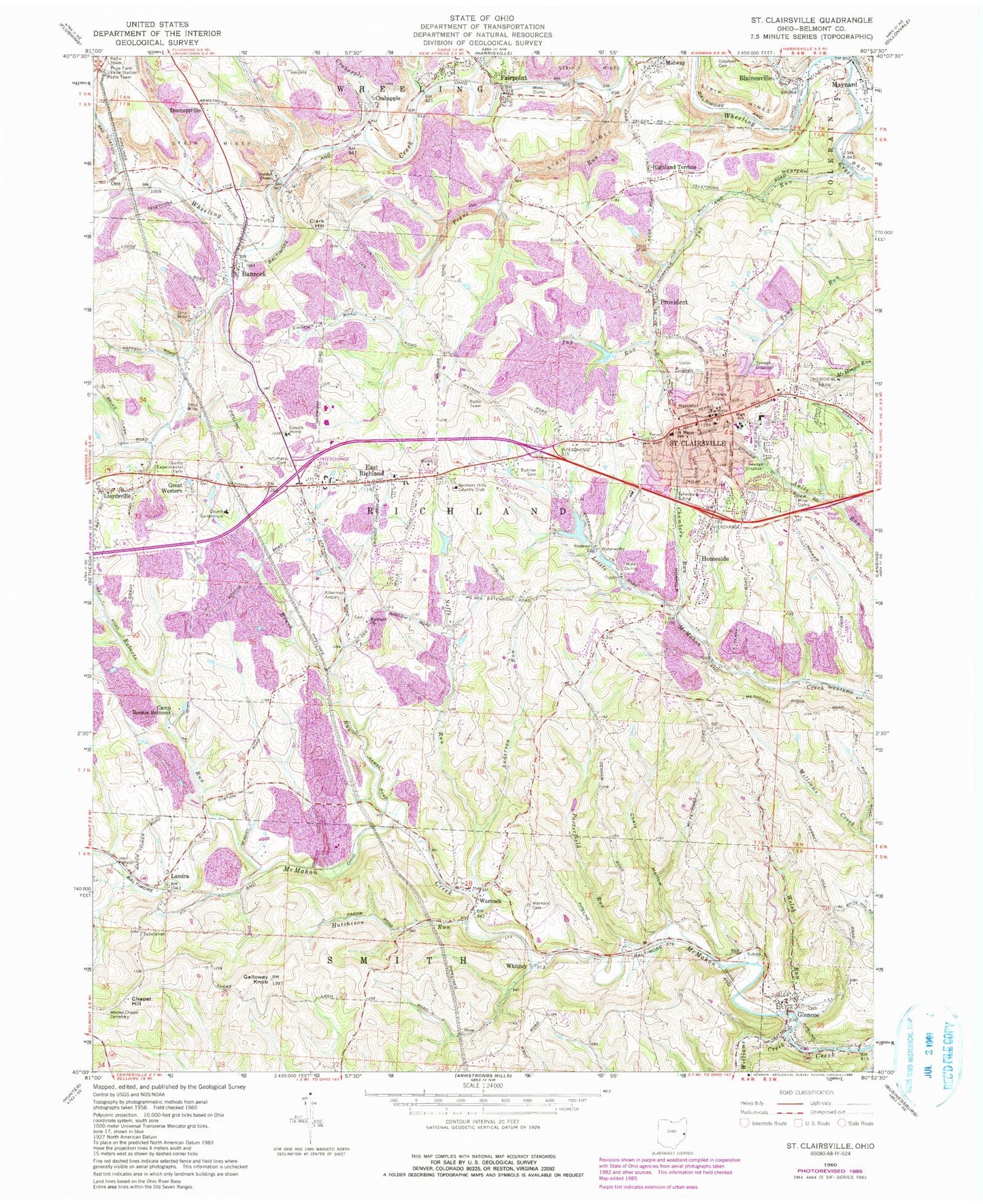
Classic USGS Saint Clairsville Ohio 7.5'x7.5' Topo Map
Couldn't load pickup availability
Historical USGS topographic quad map of Saint Clairsville in the state of Ohio. Map scale may vary for some years, but is generally around 1:24,000. Print size is approximately 24" x 27"
This quadrangle is in the following counties: Belmont.
The map contains contour lines, roads, rivers, towns, and lakes. Printed on high-quality waterproof paper with UV fade-resistant inks, and shipped rolled.
Contains the following named places: Alderman Airport, Anderson Run, Bannock, Bannock Census Designated Place, Bannock Heliport, Bannock Post Office, Belmont Correctional Institution, Belmont County, Belmont County Courthouse, Belmont County Home, Belmont County Law Library, Belmont County Sheriff's Office, Belmont Hills Country Club, Blainesville, Brush Run, Butcher Cemetery, Calvary United Presbyterian Church, Camp Bonnie Belmont, Chambers Run, Chapel Hill, City of Saint Clairsville, Clark Hill, Coaly Hollow, Coleman Cemetery, Cox Run, Crabapple, Crabapple Creek, Cumberland Run, Cumberland Trail Fire District Number 4 Station 23 - 1, Donnersville, East Richland, East Richland Cemetery, East Richland Evangelical Friends Church, East Richland Post Office, Fairpoint, Fairpoint Mennonite Church, Fairpoint Post Office, First Baptist Church, First Christian Church, First Presbyterian Church, Friends Cemetery, Galloway Knob, Glencoe, Glencoe Cemetery, Glencoe Census Designated Place, Glencoe Elementary School, Glencoe Post Office, Glencoe Volunteer Fire Department Station 25, Gordon Chapel, Great Western, Highland Terrace, Homeside, Hutchison Run, Infirmary Cemetery, Jug Run, Lamira, Lamira Post Office, Lloydsville, Lloydsville Census Designated Place, Lloydsville Post Office, Loves Run, Maynard, Maynard Community Volunteer Fire Department Station 29, Maynard Elementary School, Maynard Post Office, McCracken Run, Memorial Park, Methodist Cemetery, Midway, Mount Pisgah African Methodist Episcopal Church, Neffs Run, Oco, Pogue Run, Porterfield Run, Provident, R and F Coal Fresh Water Dam, R and F Coal Fresh Water Impoundment, Richland Church, Roberts Run, Saint Clairsville, Saint Clairsville Elementary School, Saint Clairsville High School, Saint Clairsville Middle School, Saint Clairsville Police Department, Saint Clairsville Post Office, Saint Clairsville Reservoir Number One, Saint Clairsville Reservoir Number Two, Saint Marys Roman Catholic Church, Saint Marys School, Sloan Run, Tellesburg Siding, Thoburn United Methodist Church, Township of Richland, Twin Ash Airport, Union Cemetery, Warnock, Warnock Cemetery, Warnock Post Office, Welsh Run, Wesley Chapel Cemetery, Wheeling Valley, Whitney, Whitney Post Office, Williams Creek, ZIP Codes: 43718, 43927, 43928, 43950, 43967, 43972