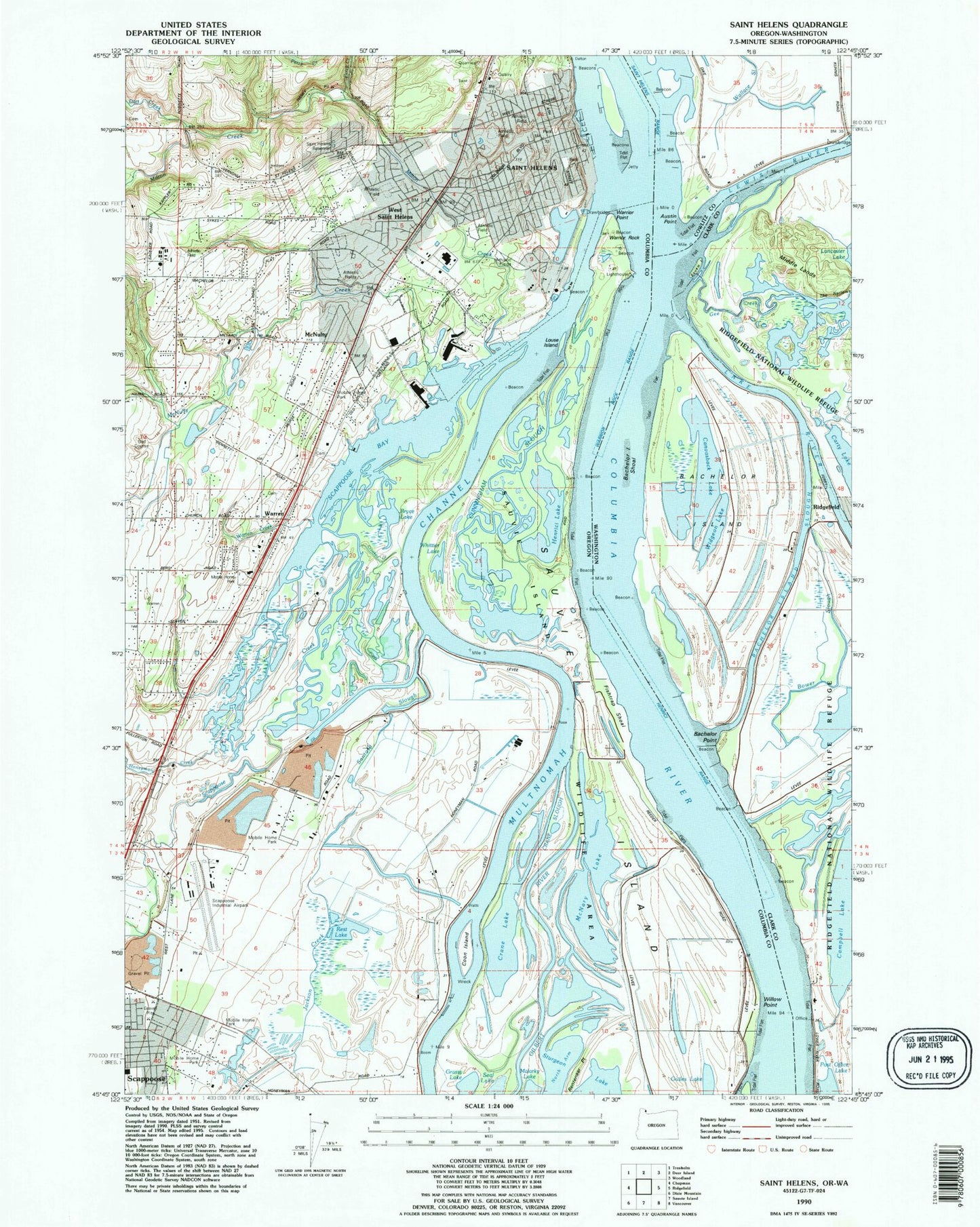
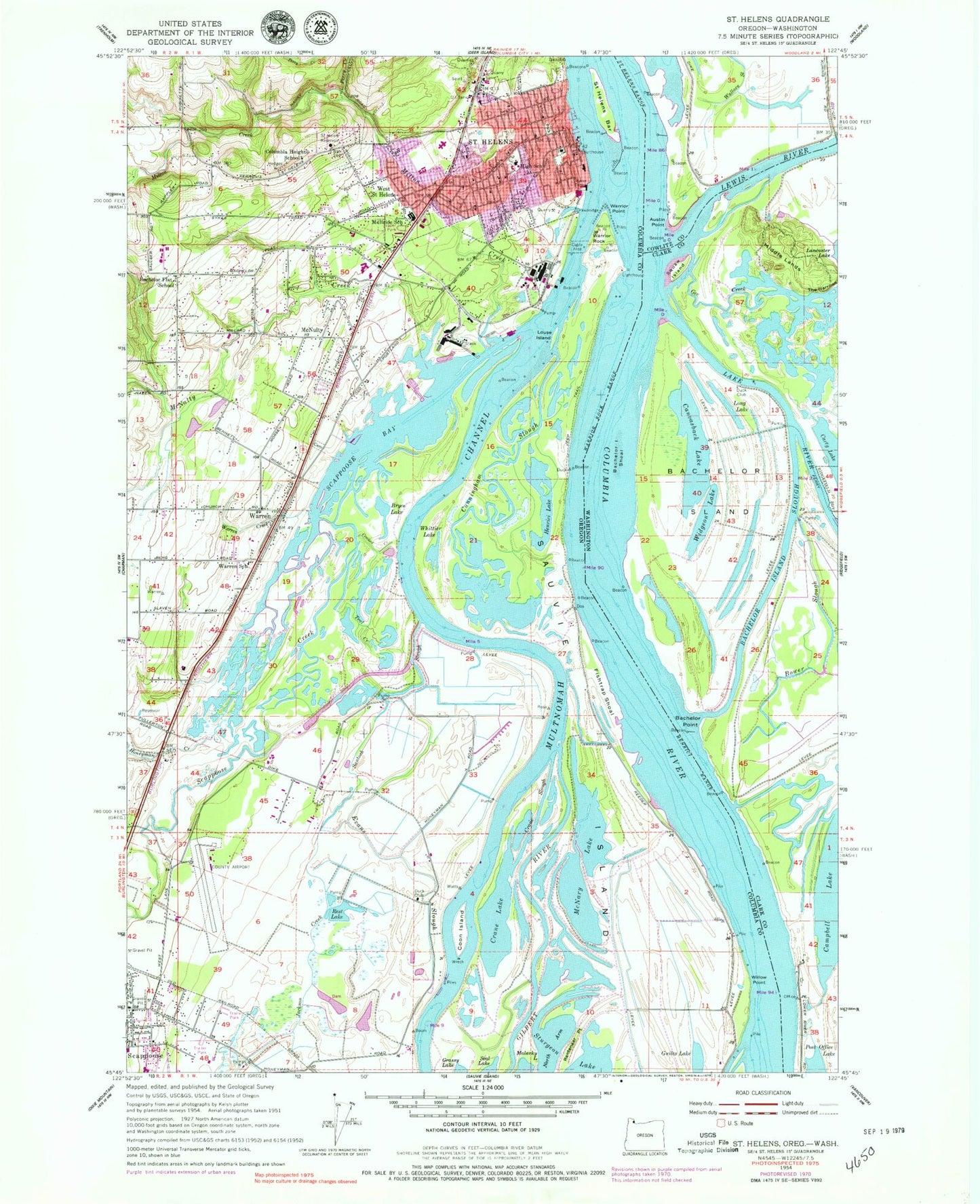
MyTopo
Classic USGS Saint Helens Oregon 7.5'x7.5' Topo Map
Couldn't load pickup availability
Historical USGS topographic quad map of Saint Helens in the states of Oregon, Washington. Typical map scale is 1:24,000, but may vary for certain years, if available. Print size: 24" x 27"
This quadrangle is in the following counties: Clark, Columbia, Cowlitz.
The map contains contour lines, roads, rivers, towns, and lakes. Printed on high-quality waterproof paper with UV fade-resistant inks, and shipped rolled.
Contains the following named places: Bachelor Flat School (historical), Bryce Lake, Columbia Heights School (historical), Coon Island, Crane Lake, Crane Slough, Crooked Creek, Cunningham Slough, Dart Creek, Duck Club, Evans Slough, Fishtrap Shoal, Gilbert River, Grassy Lake, Guiles Lake, Henrici Lake, Honeyman Creek, Jackson Creek, Louse Island, McBride School (historical), McNary Lake, McNulty, McNulty Creek, Milton Creek, North Arm, North Scappoose Creek, Perry Creek, Rentenaar Point, Rest Lake, Saint Helens Reservoir, Saint Helens, Saint Helens Bar, Santosh Slough, Scappoose Bay, Scappoose Creek, South Scappoose Creek, Teal Creek, Warren, Warren Creek, South Columbia Family School, Warrior Point, Warrior Rock, West Saint Helens, Whittier Lake, Willow Point, Rays Lake, Cunningham Lake, Aarons Lake, Columbia Memorial Gardens Cemetery, Independent Order of Odd Fellows Cemetery, Lutheran Cemetery, KOHI-AM, Scappoose Airport, Petes Slough, Sauvie Island Dam, Fales Channel, Duck Club Turn, Saint Helens High School, Columbia District Hospital, Jackass Canyon, Warrior Rock Light, Columbia Heights, Frogmore Slough, Honeyman (historical), Bachelor Flat (historical), Duck Club Light, Henrici Range, Henrici Bar (historical), Henrici Landing (historical), High School Post Office (historical), Saint Helens Post Office, Saint Helens Station A Post Office (historical), Warren Post Office, Deep Lake, Log Pond Lake, Lily Pond, Lewis and Clark Elementary School, Saint Helens Middle School, John Gumm Elementary School (historical), Civic Pride Park, Heinie Heumann Park, Domeyer Lake, Millionaire Lake, Widgeon Lake, Knighton Square, Sand Island Marine Park, Lyons Beach, McCormick Park, Boise Cascade Park (historical), Riverfront Park, Little League Park, Columbia County Fair and Rodeo Complex, Cathlacom Point, Multnomah Plywood, Cormick (historical), Texas Oil Company Spur (historical), Warrior Rock Range, Campbell Park, Godfrey Park, Nob Hill, Grant Watts Elementary School, Salene Lake (historical), Saint Helens Station, North Fork McNulty Creek, Gilbert River Boat Ramp, J J Collins Memorial Park, Scappoose R V Park, Columbia Botanical Gardens, Dalton City Park, Walnut Tree City Park, City of Saint Helens, City of Scappoose, McBride Elementary School, Church of Jesus Christ of Latter Day Saints, First Lutheran Church, Sunset Park Community Church, Warren Baptist Church, Columbia River Fire and Rescue Saint Helens Station, Columbia River Fire and Rescue Fairgrounds Station, Columbia Community Mental Health Pathways Residential Treatment Facility, Saint Helens Sewage Treatment / Boise Cascade, Scappoose Sewage Treatment Plant, Department of Motor Vehicles Saint Helens, Columbia County Courthouse, Saint Helens Municipal Court, Saint Helens City Hall, Warrior Rock Lighthouse, River City Speedway, Historical Society of Columbia County, Columbia County Public Works, Saint Helens Public Works, Saint Helens Public Library, Scappoose Public Works, Columbia County Rider Columbia Commons Park and Ride, Sand Island Marine City Park Dock South, Columbia View City Park Courthouse Docks, Columbia County Rider Rite Aid Park and Ride, Coon Island Marina, Columbia County Rider Warren Baptist Church Park and Ride, Gilbert River County Park Transient Tie Up, Port of Saint Helen's Scappoose Bay Marina, JJ Collins Memorial County Marine Park Dock East, Sand Island Marine City Park Dock North, Saint Helen's City Marina Boat Launch, JJ Collins Memorial County Marine Park Dock West, Saint Helen's City Marina, Port of Saint Helen's Scappoose Bay Marina Public Ramp, Henrici Landing Post Light, Saint Helens Bar Post Light, Columbia County Public Health Department, Saint Helens Police Department, Columbia County Sheriff's Office, Oregon State Police Department - Saint Helens Worksite, Austin Point, Bachelor Island, Bachelor Island Shoal, Bachelor Island Slough, Bachelor Point, Bower Slough, Campbell Lake, Canvasback Lake, Carty Lake, Duck Club, Gee Creek, Gee Creek, Lake River, Lancaster Lake, Long Lake, Middle Lands, Squaw Island, The Narrows, Wallace Slough, Widgeon Lake, Hathaway Lake, Ridgefield National Wildlife Refuge, Saint Helens Turn, Fales Channel, Lewis River, Cathlapotle (historical)