MyTopo
Classic USGS Saint Michaels Maryland 7.5'x7.5' Topo Map
Couldn't load pickup availability
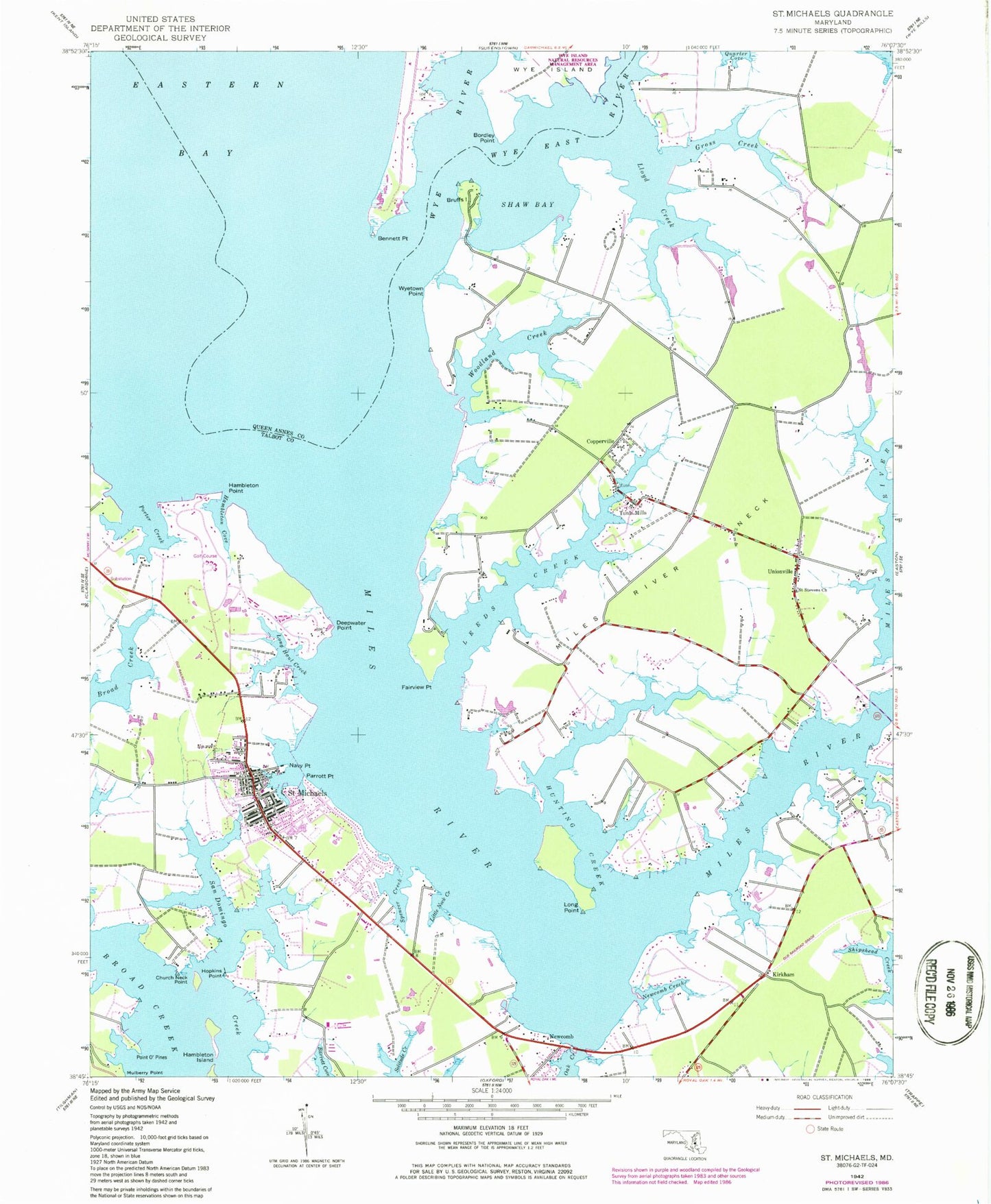
Historical USGS topographic quad map of Saint Michaels in the state of Maryland. Typical map scale is 1:24,000, but may vary for certain years, if available. Print size: 24" x 27"
This quadrangle is in the following counties: Queen Anne's, Talbot.
The map contains contour lines, roads, rivers, towns, and lakes. Printed on high-quality waterproof paper with UV fade-resistant inks, and shipped rolled.
Contains the following named places: Bruffs Island, Church Neck Point, Deepwater Point, Fairview Point, Gross Creek, Hambleton Island, Hambleton Point, Hopkins Point, Hunting Creek, Leeds Creek, Little Neck Creek, Lloyd Creek, Long Haul Creek, Long Point, Miles River, Miles River Neck, Navy Point, Newcomb Creek, Parrott Point, Porter Creek, Quarter Cove, Saint Stevens Church, San Domingo Creek, Shaw Bay, Solitude Creek, Spencer Creek, Woodland Creek, Wyetown Point, Point O' Pines, Hambleton Cove, Copperville, Kirkham, Newcomb, Saint Michaels, Tunis Mills, Unionville, All Faiths Episcopal Church, Anchorage, Arcadia Shores, Aveley, Beverly Farm, Black Duck Cove, Blakes Cove, Calhoon Meba Engineering School, Chapel Cove, Chesapeake Bay Maritime Museum, Christ Episcopal Church, Cove View, Darmands Creek, DeShields Methodist Cemetery, DeShields United Methodist Church, Doncaster, Doncaster (historical), Frederick Douglas Elementary School (historical), Grocelys Cove, Gullwing Villas, Harbourtown Country Club, Harper (historical), Hayward Cove, Ingleton, Leeds Landing, Madison Place, Maiden Point, Martingham, Meeting House Corner, Miles River Bridge, Miles River Ferry (historical), Miles River Yacht Club, Mulberry Point, Mount Pleasant Farms, Navy Point Pier, North Bend Estates, Perry Cabin Park, Porters Pride, Quail Hollow, Rays Point, Rio Vista, Riverside, Saint Luke United Methodist Church, Saint Lukes Methodist Cemetery, Saint Marys Square, Saint Marys Square Museum, Saint Michael Church of God in Christ, Saint Michaels Church, Saint Michaels Elementary School, Saint Michaels Middle High School, Saint Michaels Historic District, Saint Michaels Middle School, Saint Michaels Town Hall, Saint Stephens Graveyard, Solitude, Swan Villas, Thanksgiving, Tide Mill Cove, Todds Corner, Tricfield, Trinity African Methodist Episcopal Zion Church, Union United Methodist Church, Watch Goose Farm, Church Cove Park, Hells Crossing, Saint Michaels Village Shopping Center, Newcomb Post Office, Saint Michaels Post Office, Bennett Point, Bordley Point, Wye East River, Wye River, Saint Michaels Fire Department Station 40, Saint Michaels Police Department, Saint Luke's Preschool, Town of Saint Michaels, Talbot County Region II Wastewater Treatment Plant, Wye House Farm, Roslund Farms, Point Pleasant Farm